Related Research Articles

Pushmataha County is a county in the southeastern part of the U.S. state of Oklahoma. As of the 2020 census, the population was 10,812. Its county seat is Antlers.

Boswell is a town in Choctaw County, Oklahoma, United States. The population was 709 at the 2010 census.
Whitefield is a town in northwestern Haskell County, Oklahoma, United States. The population was 377 at the 2020 census, compared with the figure of 391 recorded in 2010. It was named for Methodist bishop George Whitefield.
Talihina is a town in LeFlore County, Oklahoma, United States, its name originating from two Choctaw words, tully and hena, meaning "iron road," a reference to the railroad around which the town was built. It is part of the Fort Smith, Arkansas–Oklahoma Metropolitan Statistical Area. The population was 925 at the time of the 2020 Census.
Wister is a town in Le Flore County, Oklahoma, United States. It is part of the Fort Smith metropolitan area. The population was 1,102 at the 2010 census. Wister is named for Gutman G. Wister, an official with the Choctaw, Oklahoma and Gulf Railroad.

Choctaw is a city in Oklahoma County, Oklahoma, United States, with a population of 12,182 at the 2020 census, a 9.3% increase from 2010. It is the oldest chartered town in Oklahoma Territory. The city is located approximately 10 miles (16.1 km) east of Oklahoma City and is part of the Oklahoma City metropolitan area.

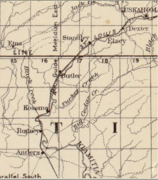
Tuskahoma is an unincorporated community and census-designated place in northern Pushmataha County, Oklahoma, United States, four miles east of Clayton. It was the former seat of the Choctaw Nation government prior to Oklahoma statehood. The population at the 2010 census was 151.
Chahta Tamaha served as the capital of the Choctaw Nation from 1863 to 1883 in Indian Territory. The town developed initially around the Armstrong Academy, which was operated by Protestant religious missionaries from 1844 to 1861 to serve Choctaw boys. After the capital was relocated to another town, this community declined.
Abbott is a former community in Pushmataha County, Oklahoma, United States, 11 miles northeast of Antlers.
Finley is an unincorporated community and Census designated place in Pushmataha County, Oklahoma, 10 miles northeast of Antlers.
Honobia is an unincorporated community on the border between western LeFlore County and eastern Pushmataha County, Oklahoma, United States, 15 miles southeast of Talihina.
Kiamichi is a former community in northern Pushmataha County, Oklahoma, United States. It is six miles east of Tuskahoma.

Rodney is a former community in Pushmataha County, Oklahoma, United States, five miles north of Antlers.
Zoraya, pronounced “Zoray”, is a ghost town in western Pushmataha County, Oklahoma, United States, west of Miller.
Nelson is an unincorporated community in northwestern Choctaw County, Oklahoma, United States. It is six miles north of Soper.
Spencerville is an unincorporated community in northern Choctaw County, Oklahoma, United States. It is 12 miles northeast of Hugo, adjacent to the Pushmataha County border. The improved Ft. Smith to Ft. Towson military road of 1839 ran north–south through Spencerville after crossing the "Seven Devils" on its way southeast to Doaksville. This wagon road was heavily used by the U.S. Army from 1839 to 1848, especially during the war with Mexico.
Johns Valley is a geographic feature and place name located in the Kiamichi Mountains in northwestern Pushmataha County, Oklahoma. The valley] is formally classified by geologists as a “basin” due to its complete encirclement by mountains.

The Choctaw Capitol Building is a historic building built in 1884 that housed the government of the Choctaw Nation of Oklahoma from 1884 to 1907. The building is located in Pushmataha County, Oklahoma, two miles north of Tuskahoma. The site also includes the Choctaw Nation Council House and the Old Town Cemetery of Tuskahoma.
Wade County was a political subdivision of the Choctaw Nation of Indian Territory, prior to Oklahoma being admitted as a state. The county formed part of the Nation's Apukshunnubbee District, or First District, one of three administrative super-regions.

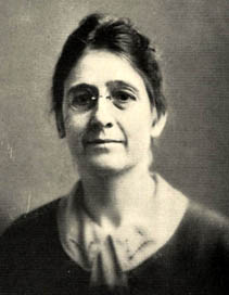
Anna Lewis (1885–1961) was a noted teacher, historian and writer, who specialized in American history, and particularly the history of the Southwest. Born in what was then Indian Territory to a family of mixed Choctaw and European ancestry, she earned doctoral degrees from University of California, Berkeley (1915) and University of Oklahoma (1930). She was the first woman to receive a Ph. D. at the University of Oklahoma. Lewis spent her educational career at the Oklahoma College for Women. She wrote two books and numerous articles for publications in her area of interest before retiring in 1956 to a home she had built in southern Oklahoma. She died in 1961.
