Related Research Articles

Pushmataha County is a county in the southeastern part of the U.S. state of Oklahoma. As of the 2020 census, the population was 10,812. Its county seat is Antlers.
Moyers is an unincorporated community located in Pushmataha County, Oklahoma, United States.
Cloudy is an unincorporated community located in Pushmataha County, Oklahoma, United States. It is 12 miles northeast of Rattan. Cloudy is located at 34°18′07″N95°16′52″W.
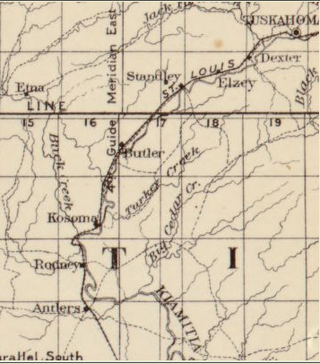
Kosoma is a ghost town and former railroad station in Pushmataha County, Oklahoma, United States. It is located just off Oklahoma State Highway 2, approximately 10 miles (16 km) north of Antlers.
Kellond is an unincorporated community and former railroad station in Pushmataha County, Oklahoma, United States. Kellond is located approximately three miles northwest of Antlers on Oklahoma State Highway 2.
Rodney Mountain is located in Pushmataha County, Oklahoma, approximately five miles northwest of Antlers, Oklahoma. It is a part of the Kiamichi Mountains, a subrange of the Ouachita Mountains, and forms its southwest-most extremity. Its summit is 767 feet above sea level. It is found at GPS coordinates 34.2984336 and −95.6410833.
Corinne is an unincorporated community in southern Pushmataha County, Oklahoma, United States, located 19 miles east of Antlers. Using the Public Land Survey System commonly in use in Oklahoma, the community is located in T22-4S-R19E.
Dunbar is a community in Pushmataha County, Oklahoma, United States, 17 miles north of Antlers.
Ethel is an unincorporated community in Pushmataha County, Oklahoma, United States, six miles east of Antlers. Ethel is located at 34°13′46″N95°32′39″W.
Finley is an unincorporated community and Census designated place in Pushmataha County, Oklahoma, 10 miles northeast of Antlers.
Jumbo is an unincorporated community in western Pushmataha County, Oklahoma, United States, 10 miles north of Miller.
Kiamichi is a former community in northern Pushmataha County, Oklahoma, United States. It is six miles east of Tuskahoma.
Rodney is a former community in Pushmataha County, Oklahoma, United States, five miles north of Antlers.
Sardis was a community in northern Pushmataha County, Oklahoma. United States. The location is six miles northwest of Clayton.
Snow is an unincorporated community in Pushmataha County, Oklahoma, United States, 18 miles northeast of Antlers.
Zoraya, pronounced "Zoray", is a ghost town in western Pushmataha County, Oklahoma, United States, west of Miller.

Snow School is a historic school building in the rural community of Snow, Oklahoma, approximately 18 miles north of Antlers, Oklahoma. The school was added to the National Register of Historic Places in 1988.
Johns Valley is a geographic feature and place name located in the Kiamichi Mountains in northwestern Pushmataha County, Oklahoma. The valley is formally classified by geologists as a "basin" due to its complete encirclement by mountains.
The Pushmataha County Historical Society is a historical society devoted to collecting and preserving the history of Pushmataha County, Oklahoma, United States. It is headquartered in the historic Frisco Depot in Antlers, Oklahoma, which it operates as a public museum.

The AT6 Monument is a granite memorial to Royal Air Force cadets who were killed while on a training flight during World War II. It stands on Big Mountain, north of Moyers, Oklahoma, in the United States, and was dedicated on February 20, 2000—the 57th anniversary of the deadly crashes.
References
- ↑ U.S. Geological Survey Geographic Names Information System: Miller, Oklahoma
- ↑ George H. Shirk, Oklahoma Place Names, p. 141; Pushmataha County Cemeteries, p. 11; Post Office Site Location Reports, Record Group 28, National Archives.
- ↑ Google Maps.
- ↑ Morris, John W. Historical Atlas of Oklahoma (Norman: University of Oklahoma, 1986), plate 38.
Municipalities and communities of Pushmataha County, Oklahoma, United States | ||
|---|---|---|
| City |  | |
| Towns | ||
| CDPs | ||
| Other communities | ||
| Ghost towns | ||
| Indian reservation | ||
| Footnotes | ‡This populated place also has portions in an adjacent county or counties | |
34°18′59″N95°44′42″W / 34.31639°N 95.74500°W
| | This Oklahoma state location article is a stub. You can help Wikipedia by expanding it. |