
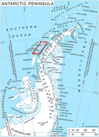
Marguerite Bay or Margaret Bay is an extensive bay on the west side of the Antarctic Peninsula, which is bounded on the north by Adelaide Island and on the south by Wordie Ice Shelf, George VI Sound and Alexander Island. The mainland coast on the Antarctic Peninsula is Fallières Coast. Islands within the bay include Pourquoi Pas Island, Horseshoe Island, Terminal Island, and Lagotellerie Island. Marguerite Bay was discovered in 1909 by the French Antarctic Expedition under Jean-Baptiste Charcot, who named the bay for his wife.

Laubeuf Fjord is a sound in Antarctica, 40 kilometres long in a north-south direction and averaging 16 km (10 mi) wide, lying between the east-central portion of Adelaide Island and the southern part of Arrowsmith Peninsula, Graham Land. It connects Hanusse Bay to the north with Marguerite Bay to the south. The southern 'border' between Laubeuf Fjord and Marguerite Bay is formed by the line between Rothera Point, Adelaide Island, and Cape Sáenz, which is the southernmost point of the Arrowsmith Peninsula. The fjord was discovered by the French Antarctic Expedition, 1908–10, under Jean-Baptiste Charcot, and named by him for Maxime Laubeuf, a French marine engineer who supervised building the engine for the ship Pourquoi-Pas.

Arrowsmith Peninsula is a cape about 40 miles (64 km) long on the west coast of Graham Land, west of Forel Glacier, Sharp Glacier and Lallemand Fjord, and northwest of Bourgeois Fjord, with Hanusse Bay lying to the northwest. It was surveyed by the Falkland Islands Dependencies Survey (FIDS) in 1955-58 and named for Edwin Porter Arrowsmith, Governor of the Falkland Islands.
Hanusse Bay is a broad, V-shaped bay, off the west coast of Graham Land, Antarctica. The bay is 37 kilometres (20 nmi) long and trends generally north–south. It is bordered by Cape Mascart on Anvers Island, and Shmidt Point on Arrowsmith Peninsula, Loubet Coast. At its north entrance, Isacke Passage separates it from Liard Island. It is bounded to the south by a line from Landauer Point, the north point of Hansen Island and Bagnold Point on Arrowsmith Peninsula.
Mount Bird is a 1,765 metres (5,791 ft) high shield volcano standing about 7 nautical miles south of Cape Bird, the northern extremity of Ross Island. It was mapped by the British National Antarctic Expedition, 1901–04, under Robert Falcon Scott, and apparently named by them after Cape Bird.
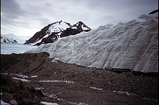
Shoesmith Glacier is the largest glacier on Horseshoe Island, flowing westward into both Lystad Bay and Gaul Cove. Named by United Kingdom Antarctic Place-Names Committee (UK-APC) in 1958 in association with Horseshoe Island.
Surveyors Range is a 30 miles (48 km) long mountain range in the Churchill Mountains of Antarctica.
Schweitzer Glacier is a glacier which drains west along the north side of Littlewood Nunataks into Vahsel Bay. The Lerchenfeld Glacier, trending west-northwestward, coalesces with the lower portion of this glacier. Discovered by the German Antarctic Expedition, 1911–12, under Wilhelm Filchner. He named it for Major Schweitzer, first president of the German Antarctic Expedition Society.

Posadowsky Glacier is a glacier about 9 nautical miles long, flowing north to Posadowsky Bay immediately east of Gaussberg. Posadowsky Bay is an open embayment, located just east of the West Ice Shelf and fronting on the Davis Sea in Kaiser Wilhelm II Land. Kaiser Wilhelm II Land is the part of East Antarctica lying between Cape Penck, at 87°43'E, and Cape Filchner, at 91°54'E, and is claimed by Australia as part of the Australian Antarctic Territory. Other notable geographic features in this area include Drygalski Island, located 45 mi NNE of Cape Filchner in the Davis Sea, and Mirny Station, a Russian scientific research station.
Willey Glacier is a heavily crevassed glacier north of Creswick Peaks in Palmer Land, flowing west from Creswick Gap into George VI Sound. Named by United Kingdom Antarctic Place-Names Committee (UK-APC) for Lawrence E. Willey, British Antarctic Survey (BAS) geologist at Fossil Bluff and Stonington Island stations, 1966–69 and 1973, and awarded the Polar Medal for services to Antarctic Survey in 1976.

Beacon Head is a small headland at the north side of the entrance to Lystad Bay on Horseshoe Island, off Graham Land. It was so named by the UK Antarctic Place-Names Committee because a timber beacon built on the headland by Argentines was used during the survey on Horseshoe Island by the Falkland Islands Dependencies Survey in 1955–57.
Mount Bridgman is a prominent mountain which surmounts the central part of Liard Island in Hanusse Bay, which is a broad V-Shaped bay off the west coast of Graham Land, Antarctica. It was mapped from photos obtained by the Ronne Antarctic Research Expedition (1947–48) and the Falkland Islands and Dependencies Aerial Survey Expedition (1956–57). It was named by the UK Antarctic Place-Names Committee for Percy W. Bridgman, an American physicist who discovered the high-pressure forms of ice.

Bucher Glacier is a small glacier draining the west slopes of Rudozem Heights and flowing to Bourgeois Fjord just north of Bottrill Head on the German Peninsula, Fallières Coast on the west side of Graham Land, Antarctica. It was named by the UK Antarctic Place-Names Committee in 1958 for Edwin Bucher, Swiss glaciologist and author of many publications on snow and avalanches.

Cole Channel is a marine channel running north–south between Wright Peninsula, Adelaide Island, and Wyatt Island, Laubeuf Fjord, off the Loubet Coast, Antarctica. It was named by the UK Antarctic Place-Names Committee in 1984 after Captain Maurice John Cole, Senior Master of the British Antarctic Survey ship Bransfield from 1975. Cole did previous Antarctic service as an officer on the John Biscoe and the Shackleton, for several seasons between 1960 and 1972.
Jennings Reef is a reef, mostly submerged, extending between Avian Island and the Rocca Islands, off the south end of Adelaide Island, Antarctica. It was named by the UK Antarctic Place-Names Committee for Leading Seaman Ronald A.J. Jennings, the coxswain of the survey motorboat Quest, used by the Royal Navy Hydrographic Survey Unit which charted the feature in 1963.
Krogh Island is an ice-covered island about 5 nautical miles (9 km) long lying close west of the southern part of Lavoisier Island in Biscoe Islands, Antarctica. The island is separated from Lavoisier Island on the east by Vladigerov Passage, from DuBois Island on the west by Papazov Passage and from Watkins Island to the south by Lewis Sound. Its north coast is indented by Transmarisca Bay and Suregetes Cove.
Lord Bank is a submarine bank in the Bellingshausen Sea with a least depth of 18 metres (60 ft) lying west-southwest of the entrance to Quest Channel, Adelaide Island, Antarctica. The bank was surveyed from HMS Endurance in January 1980 and was named by the UK Antarctic Place-Names Committee after Captain James Trevor Lord, Royal Navy, the commanding officer of HMS Endurance, 1978–80.
Mount Twigg is a large rock outcrop bisected by a north-trending glacier, standing 16 nautical miles (30 km) southeast of Mount Maguire near the head of Lambert Glacier. Mapped from ANARE air photos and surveys, 1956–58. Named by Antarctic Names Committee of Australia (ANCA) for D.R. Twigg, radio supervisor at Mawson Station, 1958.
Relay Hills is a group of low, ice-covered hills, mainly conical in shape, between Mount Edgell and Kinnear Mountains in western Antarctic Peninsula. First roughly surveyed from the ground by British Graham Land Expedition (BGLE), 1936–37. Photographed from the air by Ronne Antarctic Research Expedition (RARE), November 1947. Resurveyed by Falkland Islands Dependencies Survey (FIDS), November 1958. The name, applied by the United Kingdom Antarctic Place-Names Committee (UK-APC), arose because both the BGLE and the FIDS sledging parties had to relay their loads through this area to the head of Prospect Glacier.
