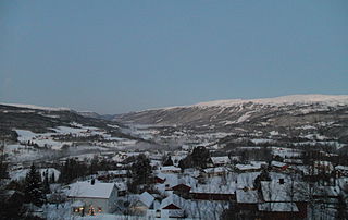
Meråker is a municipality in Trøndelag county, Norway. It is part of the Stjørdalen region. The administrative centre of the municipality is the village of Midtbygda which is about 20 kilometres (12 mi) west of Storlien in Sweden and 46 kilometres (29 mi) east of the town of Stjørdalshalsen in neighboring Stjørdal municipality. Other villages in Meråker include Gudåa, Kopperå, and Stordalen.

Inderøy is a municipality in Trøndelag county, Norway. It is part of the Innherad region. The administrative centre of the municipality is the village of Straumen. Other villages include Framverran, Gangstadhaugen, Hylla, Kjerknesvågen, Kjerringvik, Røra, Sakshaug, Sandvollan, Småland, Trongsundet, Utøy, Vangshylla, and Venneshamn. The municipality is primarily an agricultural community, but also has some industry.

Snåsa (Norwegian) or Snåase (Southern Sami) is a municipality in Trøndelag county, Norway. It is part of the Innherred region. The administrative centre of the municipality is the village of Snåsa. Other villages include Agle and Jørstad.

Verdalsøra is a town in the municipality of Verdal in Trøndelag county, Norway. The town is the administrative center of the municipality. It is located along the Trondheimsfjord at the mouth of the river Verdalselva. The village of Vinne lies 4 kilometres (2.5 mi) to the southeast, Trones lies about 5 kilometres (3.1 mi) to the north, the villages of Forbregd/Lein lie about 4 kilometres (2.5 mi) to the northeast, and the village of Stiklestad lies about 3 kilometres (1.9 mi) to the east. In 1998, the municipal council of Verdal voted to grant the urban area of Verdalsøra town status under the laws of Norway.

Vanvikan is a village in the municipality of Indre Fosen in Trøndelag county, Norway. It is located along the Trondheimsfjord in the southeastern part of the municipality. The village of Seter lies about 10 kilometres (6.2 mi) northeast of Vanvikan and the lake Storvatnet lies about 4 kilometres (2.5 mi) north of the village. One of the schools in the municipality, Vanvikan Skole is located in the village of Vanvikan. Stranda Church is also located in the village.
Selbekken is the administrative centre of the municipality of Agdenes in Trøndelag county, Norway. The village is located directly south of the village of Lensvik along the Trondheimsfjorden and the Norwegian County Road 710. The 0.48-square-kilometre (120-acre) village has a population (2018) of 390 and a population density of 813 inhabitants per square kilometre (2,110/sq mi).

Vuku is a village in the municipality of Verdal in Trøndelag county, Norway. It is located at the confluence of the rivers Helgåa and Inna where they become the Verdalselva river. The village is about 40 kilometres (25 mi) west of the village of Vera and about 15 kilometres (9.3 mi) east of the town of Verdalsøra. Vuku is also a parish covering the central part of Verdal municipality, with Vuku Church located in this village.
Trones is a headland and residential area in the municipality of Verdal in Trøndelag county, Norway. It is located about 4 kilometres (2.5 mi) north of the town of Verdalsøra, along the coast of the Trondheimsfjord. The villages of Nordskaget and Sørskaget are located on the headland, and they are combined together under the name Trones by Statistics Norway.
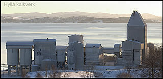
Hylla is a village in the municipality of Inderøy in Trøndelag county, Norway. Hylla is located along the Trondheimsfjord, about 2 kilometres (1.2 mi) south of the village of Røra and about 8 kilometres (5.0 mi) east of the villages of Straumen and Sakshaug. The village is home to a large limestone quarry and processing facility.
Langørjan or Rye is a village in the municipality of Trondheim in Trøndelag county, Norway. The village is located in the borough of Heimdal in the Byneset district about 12 kilometres (7.5 mi) west of the city of Trondheim and about 7.5 kilometres (4.7 mi) north of the village of Spongdal.
Årnset is the administrative centre of the municipality of Indre Fosen in Trøndelag county, Norway. It is located on the north shore of the lake Botn about 10 kilometres (6.2 mi) south of the village of Hasselvika and about 12 kilometres (7.5 mi) north of the villages of Stadsbygd and Askjem.
Feren or Færen is a lake in the municipality of Meråker in Trøndelag county, Norway. A small part in the northwestern corner of the lake extends into the municipalities of Stjørdal, Levanger, and Verdal at the outlet into the river Forra. The 26-square-kilometre (10 sq mi) lake lies about 14 kilometres (8.7 mi) north of the municipal center of Midtbygda, about 2.5 kilometres (1.6 mi) north of the lake Funnsjøen, and about 8 kilometres (5.0 mi) north of the lake Fjergen.
Forbregd and Lein are two small adjoining villages in the municipality of Verdal in Trøndelag county, Norway. Statistics Norway classifies the urban area as Forbregd/Lein. The village area is located about 4 kilometres (2.5 mi) northeast of the town of Verdalsøra and about 2 kilometres (1.2 mi) northwest of Stiklestad, along the southern shore of the lake Leksdalsvatnet. The 0.43-square-kilometre (110-acre) village has a population (2018) of 849 and a population density of 1,974 inhabitants per square kilometre (5,110/sq mi).
Trolla is a village in the municipality of Trondheim in Trøndelag county, Norway. It is located in the Midtbyen borough, along the Trondheimsfjord on the north coast of the Bymarka area. It is about 10 kilometres (6.2 mi) northeast of the village of Langørjan and about 4 kilometres (2.5 mi) northwest of the Ila neighborhood in the city of Trondheim.

Hommelvik is the administrative centre of the municipality of Malvik in Trøndelag county, Norway. The village is located at the end of the Hommelvika, a bay off of the Trondheimsfjord. Hommelvik is about 2.5 kilometres (1.6 mi) southwest of the village of Muruvika, about 4 kilometres (2.5 mi) southeast of the village of Smiskaret, about 8 kilometres (5.0 mi) east of the village of Vikhammer, and about 10 kilometres (6.2 mi) north of the village of Sneisen. The river Homla runs north through the village, emptying into the fjord. The name of the village is derived from the river name.
Leksdalvatnet is a lake in Trøndelag county, Norway that lies in the municipalities of Steinkjer and Verdal. It is located south of the town of Steinkjer and northeast of the town of Verdalsøra, about 6 kilometres (3.7 mi) east of the Trondheimsfjord. The 21.73-square-kilometre (8.39 sq mi) lake sits at an elevation of 70 metres (230 ft) above sea level. It is drained by Figgja.
Skitholvola or Sjettholvola is a mountain in the municipality of Verdal in Trøndelag county, Norway. The 611-metre (2,005 ft) tall mountain lies in the Kjølen mountain range along the Norway-Sweden border. The mountain lies near the municipal border between Verdal and Levanger to the south, about 8 kilometres (5.0 mi) south of the village of Lysthaugen.
Vera is a village in the municipality of Verdal in Trøndelag county, Norway. It is located on the northern shore of the lake Veresvatnet, about 4 kilometres (2.5 mi) west of the border with Sweden, about 2 kilometres (1.2 mi) south of the edge of Blåfjella–Skjækerfjella National Park, and about 40 kilometres (25 mi) east of the village of Vuku. Vera is also a parish covering the eastern part of Verdal municipality, with Vera Chapel located in this village.

Vinne is a village in the municipality of Verdal in Trøndelag county, Norway. It is located just south of the Verdalselva river, about 4 kilometres (2.5 mi) southeast of the town of Verdalsøra and about the same distance to the west of the village of Lysthaugen. Vinne is also a parish covering the southern part of western Verdal municipality, with Vinne Church located in this village. The Bergsgrav Station is a train stop in Vinne along the Nordlandsbanen railway line.


