Victoria Island is a large island in the Canadian Arctic Archipelago that straddles the boundary between Nunavut and the Northwest Territories of Canada. It is the eighth largest island in the world, and at 217,291 km2 (83,897 sq mi) in area, it is Canada's second largest island. It is nearly double the size of Newfoundland (111,390 km2 [43,008 sq mi]), and is slightly larger than the island of Great Britain (209,331 km2 [80,823 sq mi]) but smaller than Honshu (225,800 km2 [87,182 sq mi]). It contains the world's largest island within an island within an island. The western third of the island belongs to the Inuvik Region in the Northwest Territories; the remainder is part of Nunavut's Kitikmeot Region.

The VQ is a V6 piston engine produced by Nissan with displacements varying from 2.0 L to 4.0 L. It is an aluminum block DOHC 4-valve design with aluminum heads. It is fitted with Nissan's EGI/ECCS sequential multi-point fuel injection (MPFI) system. Later versions feature various implementations of variable valve timing and replace MPFI with direct fuel injection. The VQ series engine was honored by Ward's 10 Best Engines list almost every year from the list's inception. The VQ series replaced the VG series of engines.

The J-series is Honda's fourth production V6 engine family introduced in 1996, after the C-series, which consisted of three dissimilar versions. The J-series engine was designed in the United States by Honda engineers. It is built at Honda's Anna, Ohio and Lincoln, Alabama engine plants.
Segura de Toro is a Spanish village in the north of the province of Cáceres. There are some Celtic remains which can indicate a possible Celtic origin. It is situated by the Tras la Sierra mountains at an altitude of 715 m. It has several streams, and the main one being Garganta Ancha. The village has a Mediterranean climate and its pluviosity is 986.4 m/m. It's built on a granite formation and there are chestnuts and oaks surrounded by tree heaths and genista.

Cabezón de Cameros, a municipality in La Rioja, Spain, with a population of only 24 (2005), is one of the 10 least populated municipalities in this region, and one of the 100 least populated of Spain, as a whole. In 2001, the population was 21, and in 1991, 32. Cabezón de Cameros ranks fourth in Spain with respect to the male:female population ratio (19:5). Its surface is 12 km² and its population density, 1,75 p/km². Its geographic coordinates are: latitude, 42° 11' N, longitude: 2° 31' W, altitude: 923 meters. The distance from Logroño, the regional capital, is 43 kilometers.
German submarine U-217 was a Type VIID mine-laying U-boat of Nazi Germany's Kriegsmarine during World War II.
Pedrera is a city located in the province of Seville, Spain. According to the 2005 census (INE), the city has a population of 5143 inhabitants.
Casar de Palomero is a municipality located in the province of Cáceres, Extremadura, Spain. According to the 2005 census (INE), the municipality has a population of 1343 inhabitants.
Torre de Don Miguel is a municipality located in the province of Cáceres, Extremadura, Spain. According to the 2005 census (INE), the municipality has a population of 612 inhabitants.

Pedrosa del Príncipe is a municipality and town located in the province of Burgos, Castile and León, Spain. According to the 2004 census (INE), the municipality has a population of 217 inhabitants.
Saelices de Mayorga is a municipality located in the province of Valladolid, Castile and León, Spain. According to the 2004 census (INE), the municipality has a population of 179 inhabitants.
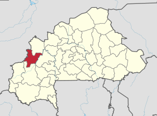
Bonza is a town in the Solenzo Department of Banwa Province in western Burkina Faso. As of 2005 it had a population of 5,209.
Dissankuy is a town in the Solenzo Department of Banwa Province in western Burkina Faso. As of 2005 it had a population of 2,794.
Tătărăști is a commune in Bacău County, Romania. It is composed of seven villages: Cornii de Jos, Cornii de Sus, Drăgești, Gherdana, Giurgeni, Tătărăști and Ungureni.
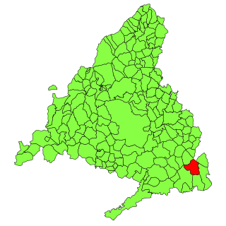
Valdaracete is a municipality of the Community of Madrid, Spain.
Sapeaçu is a municipality in the state of Bahia in the North-East region of Brazil.
Paulo Ramos, Maranhão is a municipality in the state of Maranhão in the Northeast region of Brazil.

Rafael Fernandes is a municipality in the state of Rio Grande do Norte in the Northeast region of Brazil.

Cumbie Glacier is a short, steep glacier just east of the Scott Nunataks, flowing north into the Swinburne Ice Shelf along the southwest side of Sulzberger Bay. It was mapped by the United States Geological Survey from surveys and from U.S. Navy air photos, 1959–66, and named by the Advisory Committee on Antarctic Names for William A. Cumbie, Jr., U.S. Navy. An aviation electronics technician, Cumbie was a radioman on the ski-equipped R4D aircraft carrying Rear Admiral George Dufek that was the first to land at the geographic South Pole, October 31, 1956.

Laënnec Glacier is a glacier 3 nautical miles (6 km) long draining the northeast slopes of Stribog Mountains and the northwest slopes of Avroleva Heights, and flowing northeast into Hill Bay on the east side of Brabant Island, in the Palmer Archipelago, Antarctica.