
The Podkamennaya Tunguska is a river in Krasnoyarsk Krai, Russia. It is an eastern tributary of the Yenisei and has a length of 1,160 miles (1,870 km). The name of the river comes from the fact that it flows under pebble fields without open water. As early as 1610 Russians from Mangazeya had passed the Stony Tunguska's confluence with the Yenisei; by the 1620s Mangazeya Cossacks and trappers had ascended it seeking fur-tribute from the local Tungus clans. The Tunguska event in June 1908 occurred near this river, some 8 km (5.0 mi) SSE of Lake Cheko.

The Grand Kremlin Palace, also translated Great Kremlin Palace, was built from 1837 to 1849 in Moscow, Russia on the site of the estate of the Grand Princes, which had been established in the 14th century on Borovitsky Hill. Designed by a team of architects under the management of Konstantin Thon, it was intended to emphasise the greatness of Russian autocracy. Konstantin Thon was also the architect of the Kremlin Armoury and the Cathedral of Christ the Savior.

Palmer Park is an urban park located at 201 E. 111th Street on the far South Side of Chicago, Illinois, USA.
The Diplomatic Area is an area that is located within the Central Business District of Manama, the capital city of Bahrain, an island kingdom in the Persian Gulf. Constructed on reclaimed land in the 1970s and gradually expanding in the 1980s, the Diplomatic Area is Manama's financial district, housing hundreds of banks, investment firms and Takaful societies that serve the entire Persian Gulf. It is mainly composed of high-rise office blocks and government buildings.

Kadikoi in the 19th century was a village on the Crimean peninsula, in Ukraine, about one mile north of Balaklava. The Battle of Balaclava was fought on the hills and valleys to the north of Kadikoi in 1854. The village was later known as Kadykovka (Кадыковка), and Pryhorodne (Пригородне). Currently it's merged into Balaklava city, and is known as microdistrict Kadykovka. Its original Crimean Tatar name means literally "village of a judge".
Satriwitthaya 2 School In the royal patronage of the princess mother, Srinagarindra, with 5333 students, is the most populous high school in Thailand.

Juraichhari is an Upazila of Rangamati District in the Division of Chittagong, Bangladesh.
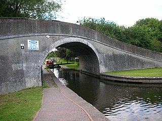
Autherley Junction is the name of the canal junction where the Shropshire Union Canal terminates and meets the Staffordshire and Worcestershire Canal near to Oxley, north Wolverhampton, West Midlands, England.
Lemyethna or Laymyethna Township is a township of Hinthada District in the Ayeyarwady Division of Myanmar.
The Whanki Museum is a private art museum in Jongno-gu, in central Seoul, South Korea. It was established by the Whanki Foundation mainly to exhibit and commemorate the art of Whanki Kim, one of Korea's foremost abstract painters. The museum is located in Buam-dong, close to Seongbuk-dong, Seongbuk-gu, where Whanki Kim and his wife spent many years. The atmosphere and natural environment of the two places have much in common. The museum building was designed by architect Kyu-seung Woo. Construction began in 1990, and the museum opened in November, 1992.
Wojtkowice-Dady is a village in the administrative district of Gmina Ciechanowiec, within Wysokie Mazowieckie County, Podlaskie Voivodeship, in north-eastern Poland.
Stokes Landing is a ghost town in Alameda County, California, United States. Stokes Landing was located along Alameda Creek east of Eden Landing. The name is in honor of James Johnstone Stokes, who founded the place in 1858. Today the area lies within the city of Hayward, California.
Liefmans is a Belgian brewery which produces oud bruin and other Belgian beers. It was founded in 1679. The company went bankrupt in 2008 and was acquired by Duvel Moortgat. Liefmans' wheat beer, Dentergems Wit, and a Belgian ale, Lucifer, were subsequently taken over by Het Anker Brewery.
Cruzeiro do Iguaçu is a municipality in the state of Paraná in the Southern Region of Brazil.

The National Museum of Medieval Art is an Albanian national museum dedicated to medieval art and history in Korçë, Albania. The museum is located on Fan Noli Boulevard in the south-east of the city of Korça. It was established on April 24, 1980 and the building was reconstructed on October 04, 2016 with the cooperation of the city municipality and the Greek Government found.

The Resurrection of Christ Orthodox Cathedral of Korçë is the main orthodox church in Korçë, Albania. It is painted in pink, blue and brown. The cathedral was built by Greece in 1995. A previous cathedral in Korçë named after St. Geroge was destroyed by the Communist authorities in 1968.
Akpadanou is an arrondissement in the Ouémé department of Benin. It is an administrative division under the jurisdiction of the commune of Adjohoun. According to the population census conducted by the Institut National de la Statistique Benin on February 15, 2002, the arrondissement had a total population of 6158.
The English River Dene Nation is a Dene First Nation band government in Patuanak, Saskatchewan, Canada. Their reserve is in the northern section of this Canadian province. Its territories are in the boreal forest of the Canadian Shield. This First Nation is a member of the Meadow Lake Tribal Council (MLTC).
Atomfjella is a mountain range in Ny-Friesland at Spitsbergen, Svalbard, Norway. It is located between Austfjorden to the west and Planetfjella to the east, Smutsdalen and Smutsbreen to the south, and Reinsbukkdalen and Reinsbukkbreen to the north. Many of the mountains in Atomfjella have names from nuclear physics. The mountain range includes Perriertoppen, Nøytronfjellet, Elektronfjellet, Radiumfjellet, Curiefjellet, Rutherfordfjellet, Grøssfjellet, Einsteinfjellet, Bohrryggen and others.
Královo Pole is a district of Brno, second largest city in the Czech Republic.


