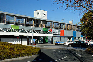
Kakegawa Station is an interchange railway station in Kakegawa, Shizuoka Prefecture, Japan, on the Tōkaidō Shinkansen, Tōkaidō Main Line, and Tenryū-Hamanako Railway. It is located 239.3 kilometers from Tokyo Station. It is operated by Central Japan Railway Company.

Marcinkowo Dolne is a village in the administrative district of Gmina Gąsawa, within Żnin County, Kuyavian-Pomeranian Voivodeship, in north-central Poland. It lies approximately 4 kilometres (2 mi) west of Gąsawa, 9 km (6 mi) south of Żnin, and 44 km (27 mi) south-west of Bydgoszcz.
Głęboczek is a village in the administrative district of Gmina Rogowo, within Żnin County, Kuyavian-Pomeranian Voivodeship, in north-central Poland.

Annopol is a village in the administrative district of Gmina Hrubieszów, within Hrubieszów County, Lublin Voivodeship, in eastern Poland, close to the border with Ukraine. It lies approximately 11 kilometres (7 mi) north of Hrubieszów and 101 km (63 mi) east of the regional capital Lublin.

Jałowy Róg is a settlement in the administrative district of Gmina Płaska, within Augustów County, Podlaskie Voivodeship, in north-eastern Poland, close to the border with Belarus. It lies approximately 11 kilometres (7 mi) east of Płaska, 30 km (19 mi) east of Augustów, and 89 km (55 mi) north of the regional capital Białystok.

Winduga is a settlement in the administrative district of Gmina Sulejów, within Piotrków County, Łódź Voivodeship, in central Poland. It lies approximately 9 kilometres (6 mi) south of Sulejów, 21 km (13 mi) south-east of Piotrków Trybunalski, and 64 km (40 mi) south-east of the regional capital Łódź.

Bąki is a village in the administrative district of Gmina Zadzim, within Poddębice County, Łódź Voivodeship, in central Poland. It lies approximately 9 kilometres (6 mi) east of Zadzim, 15 km (9 mi) south of Poddębice, and 34 km (21 mi) west of the regional capital Łódź.

Zalesie is a village in the administrative district of Gmina Wielgomłyny, within Radomsko County, Łódź Voivodeship, in central Poland. It lies approximately 3 kilometres (2 mi) north of Wielgomłyny, 23 km (14 mi) east of Radomsko, and 86 km (53 mi) south of the regional capital Łódź.

Budzów is a village in the administrative district of Gmina Żytno, within Radomsko County, Łódź Voivodeship, in central Poland. It lies approximately 9 kilometres (6 mi) south-east of Żytno, 28 km (17 mi) south-east of Radomsko, and 100 km (62 mi) south of the regional capital Łódź.
Zawady-Ponikiew is a village in the administrative district of Gmina Różan, within Maków County, Masovian Voivodeship, in east-central Poland.

Kurówko is a village in the administrative district of Gmina Krasne, within Przasnysz County, Masovian Voivodeship, in east-central Poland. It lies approximately 13 kilometres (8 mi) south of Przasnysz and 77 km (48 mi) north of Warsaw.
Kamionna is a village in the administrative district of Gmina Łochów, within Węgrów County, Masovian Voivodeship, in east-central Poland.
Majdan is a village in the administrative district of Gmina Łochów, within Węgrów County, Masovian Voivodeship, in east-central Poland.

Pisarzowice is a village in the administrative district of Gmina Kobyla Góra, within Ostrzeszów County, Greater Poland Voivodeship, in west-central Poland. It lies approximately 8 kilometres (5 mi) south-west of Kobyla Góra, 18 km (11 mi) south-west of Ostrzeszów, and 133 km (83 mi) south-east of the regional capital Poznań.

Kręcka Winnica is a settlement in the administrative district of Gmina Zbąszynek, within Świebodzin County, Lubusz Voivodeship, in western Poland. It lies approximately 6 kilometres (4 mi) south-west of Zbąszynek, 17 km (11 mi) east of Świebodzin, 35 km (22 mi) north-east of Zielona Góra, and 69 km (43 mi) south-east of Gorzów Wielkopolski.

Rytel-Zarzecze is a village in the administrative district of Gmina Czersk, within Chojnice County, Pomeranian Voivodeship, in northern Poland. It lies approximately 15 kilometres (9 mi) west of Czersk, 16 km (10 mi) east of Chojnice, and 89 km (55 mi) south-west of the regional capital Gdańsk.

Nowe Słone is a settlement in the administrative district of Gmina Dziemiany, within Kościerzyna County, Pomeranian Voivodeship, in northern Poland. It lies approximately 4 kilometres (2 mi) north of Dziemiany, 17 km (11 mi) south-west of Kościerzyna, and 68 km (42 mi) south-west of the regional capital Gdańsk.

Parszkowo is a village in the administrative district of Gmina Krokowa, within Puck County, Pomeranian Voivodeship, in northern Poland. It lies approximately 7 kilometres (4 mi) east of Krokowa, 12 km (7 mi) north-west of Puck, and 51 km (32 mi) north-west of the regional capital Gdańsk.

Smolne is a village in the administrative district of Gmina Będzino, within Koszalin County, West Pomeranian Voivodeship, in north-western Poland. It lies approximately 9 kilometres (6 mi) south-west of Będzino, 19 km (12 mi) west of Koszalin, and 120 km (75 mi) north-east of the regional capital Szczecin.

Sokolinaya gora District is an administrative district (raion) of Eastern Administrative Okrug, and one of the 125 raions of Moscow, Russia. The area of the district is 7.961 square kilometers (3.074 sq mi). Population: 84,100.


