Mac-Mac Falls

Last updated

Mac-Mac Falls
Mac Mac Falls (46776220411).jpg
Mac-Mac Falls
Mac-Mac Falls
LocationMac-Mac Forest Nature Reserve, Mpumalanga, South Africa
Coordinates 25°00′02″S30°48′58″E / 25.00056°S 30.81611°E / -25.00056; 30.81611
Total height65 metres (213 ft)
Number of drops1
Watercourse Mac-Mac River

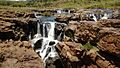
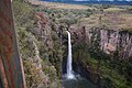
The Mac-Mac Falls is a 65-metre waterfall on the Mac-Mac River in the Mac-Mac Forest Nature Reserve, Mpumalanga, South Africa.

Contents

History

Originally, the waterfall had a single stream, but miners used dynamite on the waterfall in the hopes of exposing the gold-rich reef, which now has the water falling in two streams. [1]

It was declared a Provincial Heritage Site February 18, 1983, along with the indigenous forest in the kloof below the waterfall. [2]

See also

Related Research Articles

<span class="mw-page-title-main">Waterfall</span> A point in a river or stream where water flows over a vertical drop

A waterfall is any point in a river or stream where water flows over a vertical drop or a series of steep drops. Waterfalls also occur where meltwater drops over the edge of a tabular iceberg or ice shelf.

Bridal Veil Falls, Bridalveil Falls or Bridalveil Fall is a frequently-used name for waterfalls that observers fancy resemble a bride's veil:

<span class="mw-page-title-main">Transylvania County, North Carolina</span> County in North Carolina, United States

Transylvania County is a county in the U.S. state of North Carolina. As of the 2020 census the population is 32,986. Its county seat is Brevard.

<span class="mw-page-title-main">Macon County, North Carolina</span> County in North Carolina, United States

Macon County is a county located in the U.S. state of North Carolina. As of the 2020 census, the population was 37,014. Its county seat is Franklin.

<span class="mw-page-title-main">Angel Falls</span> Tallest single drop waterfall in the world, Venezuela

Kerepakupai merú. Receiving its name of after the American adventurer James Angel landed his plane there in 1937 Angel Falls is a waterfall in Venezuela. It is the world's tallest uninterrupted waterfall, with a height of 979 metres (3,212 ft), and a plunge of 807 m (2,648 ft). The waterfall drops over the edge of the Auyán-tepui mountain in the Canaima National Park, a UNESCO World Heritage Site in the Gran Sabana region of Bolívar State. The height figure, 979 m (3,212 ft), mostly consists of the main plunge but also includes about 400 metres (1,300 ft) of sloped cascade and rapids below the drop and a 30-metre-high (100 ft) plunge downstream of the talus rapids.

<span class="mw-page-title-main">Sabie</span> Place in Mpumalanga, South Africa

Sabie is a forestry town situated on the banks of the Sabie River in Mpumalanga, South Africa. The name Sabie is derived from the siSwati word "Ulusaba" which means "fearful river" because the river was once teeming with dangerous Nile crocodile. The word Ulusaba was modernized by the Afrikaner settlers who changed it from Ulusaba (siSwati) into the Afrikaans "Sabie".

<span class="mw-page-title-main">Tsitsikamma National Park</span> Protected area on the Garden Route, Western Cape and Eastern Cape, South Africa

The Tsitsikamma National Park is a protected area on the Garden Route, Western Cape and Eastern Cape, South Africa. It is a coastal reserve well known for its indigenous forests, dramatic coastline, and the Otter Trail. On 6 March 2009 it was amalgamated with the Wilderness National Park and various other areas of land to form the Garden Route National Park.

<span class="mw-page-title-main">Purling Brook Falls</span> Waterfall in South East Queensland, Australia

The Purling Brook Falls or sometimes incorrectly Purlingbrook Falls, a horsetail waterfall on the Purling Brook, is located in the UNESCO World Heritage–listed Gondwana Rainforests in the South East region of Queensland, Australia.

<span class="mw-page-title-main">Sabie River</span> River in South Africa, Mozambique

The Sabie River is a river in South Africa that forms part of the Komati River System. The catchment area of the Sabie-Sand system is 6,320 km2 in extent. The Sabie is one of the most biologically diverse rivers in South Africa, with generally good water quality.

<span class="mw-page-title-main">Salt Creek Falls</span> Waterfall in Lane County, Oregon

Salt Creek Falls is a cascade and plunge waterfall on Salt Creek, a tributary of the Middle Fork Willamette River, that plunges into a gaping canyon in the Willamette National Forest near Willamette Pass in Lane County, Oregon. The waterfall is notable for its main drop of 286 feet (87 m), ranking third highest among plunge waterfalls in Oregon, after Multnomah Falls and Watson Falls.) The pool at the bottom of Salt Creek Falls waterfall is 66 feet (20 m) deep.

<span class="mw-page-title-main">Berlin Falls</span> Waterfall in Mpumalanga, South Africa

The Berlin Falls is a waterfall in Mpumalanga, South Africa. They are located close to God's Window and the highest waterfall in South Africa's Mpumalanga province, Lisbon Falls. They are less than a tenth of the height of South Africa's tallest waterfall, the Tugela Falls, and are better known for their beauty.

<span class="mw-page-title-main">Zapata Falls</span> Waterfall in San Luis Valley, Colorado

Zapata Falls is a waterfall located in the San Luis Valley near the base of the Sangre de Cristo Mountains on Bureau of Land Management land adjacent to Rio Grande National Forest and south of Great Sand Dunes National Park and Preserve in Alamosa County, Colorado. The waterfall has a drop of about 30 feet (9 m). Access to this waterfall entails a mildly steep 0.5-mile (800 m) hike. Viewing the falls requires fording the stream and climbing rocks.

<span class="mw-page-title-main">Triplet Falls</span> Waterfall in Victoria, Australia

The Triplet Falls are waterfalls located in the Great Otway National Park of Victoria, in eastern Australia, 200 km from Melbourne via Colac and Gellibrand, or 70 km from Apollo Bay.

<span class="mw-page-title-main">Bronkhorst Spruit</span> River in Gauteng and Mpumalanga, South Africa

The Bronkhorst Spruit, meaning watercress stream or creek, is a river in the Mpumalanga and Gauteng provinces of South Africa. In the 19th century it as was known as the Kalkoenkransrivier or Rhenosterpoortrivier. It is a tributary of the Wilge River in the Olifants River basin, and it lends its name to the town of Bronkhorstspruit, situated mainly on its right bank.

<span class="mw-page-title-main">Lisbon Falls (waterfall)</span> Waterfall in Mpumalanga, South Africa

The Lisbon Falls are falls in the Lisbon Creek, a right bank tributary of the Blyde River. They are situated a short distance north of Graskop beside the R532 road, and are the highest waterfalls in Mpumalanga, South Africa. The waterfalls are 94 metres (308 ft) high and were named for the Lisbon Creek and the Farm Lisbon, on which the falls are located.

<span class="mw-page-title-main">Lone Creek Falls</span> Waterfall in Mpumalanga, South Africa

The Lone Creek Falls is near Sabie in Mpumalanga, South Africa. The waterfall plummets 70 m down into the Creek.

<span class="mw-page-title-main">Bridal Veil Falls (Sabie)</span>

The Bridal Veil Falls is six kilometres outside Sabie, Mpumalanga in South Africa. It is 70 metres high. The falls is slow flowing under normal conditions making it appear like a veil, hence its name. It is one of many waterfalls in the area that is located on the Sabie River and is a popular tourist destination. It is accessible by car, with parking and a picnic area on SAFCOL's grounds. Local curio dealers sell arts and crafts from the car park area. From the car park, a footpath runs through indigenous forest for about 750 metres directly to the waterfall.

Mac-Mac is a historical area in the Mpumalanga province of South Africa, and the site of the country's earliest gold rush. It is located near the town of Sabie, 5 km from Pilgrim's Rest.

<span class="mw-page-title-main">Panorama Route</span> Road in South Africa

The Panorama Route is a scenic road in South Africa connecting several cultural and natural points of interest. The route, steeped in the history of South Africa, is in Mpumalanga province, centred around the Blyde River Canyon, the world's third largest canyon. It features numerous waterfalls, one of the largest afforested areas in South Africa, and several natural landmarks. The route starts at the foot of the Long Tom Pass just outside Lydenburg, following the natural descent from the Great Escarpment to the Lowveld, and ending at the border of the Mpumalanga and Limpopo provinces near the Echo Caves.

<span class="mw-page-title-main">Oorlogskloof Nature Reserve</span> Nature reserve in South Africa

The Oorlogskloof Nature Reserve, covers 4,776 hectares and is located 10 km south of Nieuwoudtville in the Northern Cape, South Africa.

References

  1. "Mac Mac Falls: Sabie Gallery". www.sabie.co.za. Retrieved 17 March 2023.
  2. "Mac Mac Waterfalls, Geelhoutboom, Pilgrim's Rest District | SAHRA". SAHRA . Retrieved 17 March 2023.