
Whitehorse is the capital of the Yukon, and the largest city in Northern Canada. It was incorporated in 1950 and is located at kilometre 1426 on the Alaska Highway in southern Yukon. Whitehorse's downtown and Riverdale areas occupy both shores of the Yukon River, which rises in British Columbia and meets the Bering Sea in Alaska. The city was named after the White Horse Rapids for their resemblance to the mane of a white horse, near Miles Canyon, before the river was dammed.

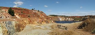
Faro is a town in central Yukon, Canada, the home of the now abandoned Faro Mine. It was the largest open-pit lead–zinc mine in the world as well as a significant producer of silver and other natural resources. The mine was built by the Ralph M. Parsons Construction Company of the United States with General Enterprises Ltd. of Whitehorse being the main subcontractor. As of 2021, the population is 440, down from its peak population of 1,652 in 1981. Faro was named after the card game of the same name.

The White Pass and Yukon Route is a Canadian and U.S. Class III 3 ft narrow-gauge railroad linking the port of Skagway, Alaska, with Whitehorse, the capital of Yukon. An isolated system, it has no direct connection to any other railroad. Equipment, freight and passengers are ferried by ship through the Port of Skagway, and via road through a few of the stops along its route.

The District of Alaska was the federal government’s designation for Alaska from May 17, 1884, to August 24, 1912, when it became the Territory of Alaska. Previously (1867–1884) it had been known as the Department of Alaska, a military designation.
The Klondike Highway is a highway that runs from the Alaska Panhandle through the province of British Columbia and the territory of Yukon in Canada, linking the coastal town of Skagway, Alaska, to Dawson City, Yukon. Its route somewhat parallels the route used by prospectors in the 1898 Klondike Gold Rush.

Kennecott, also known as Kennicott and Kennecott Mines, is an abandoned mining camp in the Copper River Census Area in the U.S. state of Alaska that was the center of activity for several copper mines. It is located beside the Kennicott Glacier, northeast of Valdez, inside Wrangell-St. Elias National Park and Preserve. The camp and mines are now a National Historic Landmark District administered by the National Park Service.

The Yukon Quest, formally the Yukon Quest 1,000-mile International Sled Dog Race, is a sled dog race scheduled every February since 1984 between Fairbanks, Alaska, and Whitehorse, Yukon, switching directions each year. Because of the harsh winter conditions, difficult trail, and the limited support that competitors are allowed, it is considered the "most difficult sled dog race in the world", or even the "toughest race in the world"—"even tougher, more selective and less attention-seeking than the Iditarod Trail Sled Dog Race." The originator envisioned it as "a race so rugged that only purists would participate."

Yukon is in the northwestern corner of Canada and is bordered by Alaska, British Columbia and the Northwest Territories. The sparsely populated territory abounds with natural scenery, snowmelt lakes and perennial white-capped mountains, including many of Canada's highest mountains. The territory's climate is Arctic in territory north of Old Crow, subarctic in the region, between Whitehorse and Old Crow, and humid continental climate south of Whitehorse and in areas close to the British Columbia border. Most of the territory is boreal forest with tundra being the main vegetation zone only in the extreme north and at high elevations.

The Copperbelt is a natural region in Central Africa which sits on the border region between northern Zambia and the south eastern Democratic Republic of Congo. It is known for copper mining.
Marsh Lake is a widening of the Yukon River southeast of Whitehorse, Yukon, Canada. It is over 30 kilometres (19 mi) long and ranges from three to four kilometres wide. It has an area of 96.3 km2 (37.2 sq mi) and a mean depth of 12.8 m (42 ft). The co-ordinates of the lake are 60°26′10″N134°15′02″W, and is 654 metres (2,147 ft) above sea level. The lake forms part of a chain of finger lakes, sometimes referred to as "The Southern Lakes", that form the headwaters of the Yukon River.

The history of the Yukon covers the period from the arrival of Paleo-Indians through the Beringia land bridge approximately 20,000 years ago. In the 18th century, Russian explorers began to trade with the First Nations people along the Alaskan coast, and later established trade networks extending into Yukon. By the 19th century, traders from the Hudson's Bay Company were also active in the region. The region was administered as a part of the North-Western Territory until 1870, when the United Kingdom transferred the territory to Canada and it became the North-West Territories.
The São Domingos Mine is a deserted open-pit mine in Corte do Pinto, Mértola municipality, Alentejo region, Portugal. This site is one of the volcanogenic massive sulfide ore deposits in the Iberian Pyrite Belt, which extends from the southern Portugal into Spain. It was the first place in Portugal to have electric lighting.
Silver mining in Arizona was a powerful stimulus for exploration and prospecting in early Arizona. Cumulative silver production through 1981 totaled 490 million troy ounces. However, only about 10% of Arizona's silver production came from silver mining. More than 80% of the state's silver was a byproduct of copper mining; other silver came as a byproduct of lead, zinc, and gold mining.
Gold mining in Alaska, a state of the United States, has been a major industry and impetus for exploration and settlement since a few years after the United States acquired the territory in 1867 from the Russian Empire. Russian explorers discovered placer gold in the Kenai River in 1848, but no gold was produced. Gold mining started in 1870 from placers southeast of Juneau, Alaska.
The Copper Queen Mine was a copper mine in Cochise County, Arizona, United States. Its development led to the growth of the surrounding town of Bisbee in the 1880s. Its orebody ran 23% copper, an extraordinarily high grade. It was acquired by Phelps Dodge in 1885.
The Cobalt silver rush was a silver rush in Ontario, Canada that began in 1903 when huge veins of silver were discovered by workers on the Temiskaming and Northern Ontario Railway (T&NO) near the Mile 103 post. By 1905 a full-scale silver rush was underway, and the town of Cobalt, Ontario sprang up to serve as its hub. By 1908 Cobalt produced 9% of the world's silver, and in 1911 produced 31,507,791 ounces of silver. However, the good ore ran out fairly rapidly, and most of the mines were closed by the 1930s. There were several small revivals over the years, notably in World War II and again in the 1950s, but both petered out and today there is no active mining in the area. In total, the Cobalt area mines produced 460 million ounces of silver.
In an effort to thwart statehood and Alaskan home rule from Washington D.C., the Alaska Syndicate, was formed in 1906 by J. P. Morgan and Simon Guggenheim. The Syndicate purchased the Kennicott-Bonanza copper mine and had majority control of the Alaskan steamship and rail transportation. The syndicate also was in charge of a large part of the salmon industry.

Roan Antelope is a copper mine in Zambia. The deposits were discovered in 1902, but their full extent was not understood until 1926. The mine site was developed between 1927 and 1931, at first experiencing many deaths from malaria due to poor drainage. Production since then has experienced various slumps and booms. The mine was nationalized in 1970 and returned to private ownership in 1997. The new owners struggled to make it profitable, and it changed hands twice.

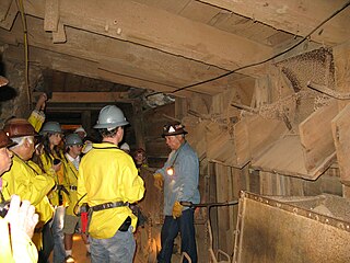
The MacBride Museum of Yukon History is a non profit museum located in Whitehorse, Yukon, Canada. Founded in 1950 by the Yukon Historical Society, and opened in 1952, it is the oldest museum in the Yukon. Funding to expand the museum was approved in 2016 by the Department of Canadian Heritage and Government of Yukon, with the co-operation of the City of Whitehorse. The museum consists of three sites: the MacBride Museum, MacBride Roundhouse, and the MacBride Copperbelt Mining Museum.

Uranium mining in the Elliot Lake area represents one of two major uranium-producing areas in Ontario, and one of seven in Canada.
