Argyll and Bute is one of 32 unitary council areas in Scotland and a lieutenancy area. The current lord-lieutenant for Argyll and Bute is Jane Margaret MacLeod. The administrative centre for the council area is in Lochgilphead at Kilmory Castle, a 19th-century Gothic Revival building and estate. The current council leader is Councillor Jim Lynch.
Royal Air Force Machrihanish or RAF Machrihanish is a former Royal Air Force station located near the town of Machrihanish and 3.5 miles (5.6 km) west of Campbeltown, at the tip of the Kintyre peninsula, Argyll and Bute, in Scotland.
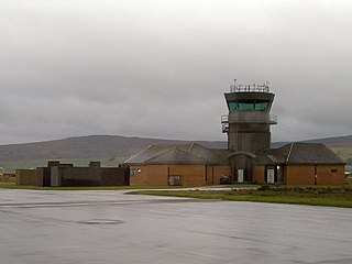
Campbeltown Airport is located at Machrihanish, 3 nautical miles west of Campbeltown, near the tip of the Kintyre peninsula in Argyll and Bute on the west coast of Scotland.
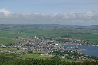
Campbeltown is a town and former royal burgh in Argyll and Bute, Scotland. It lies by Campbeltown Loch on the Kintyre Peninsula. Campbeltown became an important centre for Scotch whisky, and a busy fishing port.

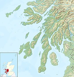
Kintyre is a peninsula in western Scotland, in the southwest of Argyll and Bute. The peninsula stretches about 30 miles, from the Mull of Kintyre in the south to East and West Loch Tarbert in the north. The region immediately north of Kintyre is known as Knapdale.

The Mull of Kintyre is the southwesternmost tip of the Kintyre Peninsula in southwest Scotland. From here, the Antrim coast of Northern Ireland is visible on a calm and clear day, and a historic lighthouse, the second commissioned in Scotland, guides shipping in the intervening North Channel. The area has been immortalised in popular culture by the 1977 hit song "Mull of Kintyre" by Kintyre resident Paul McCartney's band of the time, Wings.

Carradale is a village on the east side of the Kintyre Peninsula, overlooking the Kilbrannan Sound and the west coast of the Isle of Arran in the Firth of Clyde, approximately 16 miles from Campbeltown. To the north of Carradale is the coastal peak known as Torr Mor; nearby are the hamlet of Dippen and Dippen Bay. Population: 577 ~ 2024

Saddell is a small Scottish village situated on the east side of the Kintyre Peninsula of Argyll and Bute, overlooking the Kilbrannan Sound and the Isle of Arran, 8 miles (13 km) from Campbeltown on the B842 road to Carradale. The name Saddell is derived from the Norse for sandy dale.

Southend is the main settlement at the southern end of the Kintyre peninsula in Argyll and Bute, Scotland. It lies 8 miles (13 km) south of Campbeltown, the main town in the area. The civil parish of Southend comprises the village and the surrounding land, used mainly for farming and forestry. The population of the parish is 497.

Tarbert is a village in the west of Scotland, in the Argyll and Bute council area. It is built at the head of an inlet of Loch Fyne called East Loch Tarbert, on a narrow isthmus which connects Kintyre to the south with Knapdale to the north and separates East Loch Tarbert from the much longer West Loch Tarbert. Tarbert had a recorded population of 1,338 in the 2001 Census.

The Campbeltown and Machrihanish Light Railway was a 2 ft 3 in narrow-gauge railway in Kintyre, Scotland, between Campbeltown and the coalmining village of Machrihanish. Only three other passenger-carrying lines in the UK operated on the same gauge, all of them in Wales - the Corris Railway, the short-lived Plynlimon and Hafan Tramway and the Talyllyn Railway.

Machrihanish is a village in Argyll and Bute, on the west coast of Scotland. It is a short distance north of the tip of the Mull of Kintyre, which faces out towards Northern Ireland and the Atlantic.

Claonaig is a hamlet on the east coast of the Kintyre peninsula in western Scotland, linked to Lochranza on the Isle of Arran by the CalMac ferry MV Catriona in the summer months.

Drumlemble is a small village on the Kintyre peninsula in Argyll and Bute, Scotland.

Tayinloan is a village situated on the west coast of the Kintyre peninsula in Argyll and Bute, Scotland. The village has a sub post office, general store and a small hotel, a village hall and a play park. There is a cafe bar situated beside the ferry car park which also offers self-catering or bed and breakfast accommodation. The nearest towns are Campbeltown and Tarbert.
The Machrihanish Coalfield is a coalfield on the Kintyre peninsula in southwest Scotland. It is one of the smallest British coalfields. With the exception of a thin coal beneath the Lyoncross Limestone in the overlying Upper Limestone Formation, all of the coal-bearing strata are found within the Limestone Coal Formation, a subdivision of the Clackmannan Group; all being strata of Namurian age. There are numerous seams of which the Main Coal is the principal one, being some 3 to 4m thick. A further, higher seam known as the Kilkivan Coal has also been worked. The full sequence is:
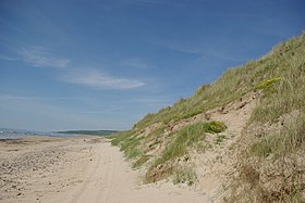
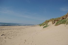
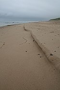
The Gauldrons (Scottish Gaelic: Innean nan Gailleann meaning "Bay of Storms" is a bay facing the Atlantic Ocean in the village of Machrihanish in Argyll, on the west coast of Scotland, a short distance north of the tip of the Mull of Kintyre.

Enard Bay is a large remote tidal coastal embayment, located 10.5 miles northwest of Ullapool, in northwestern Ross and Cromarty, Scottish Highlands in the west coast of Scotland. The mouth of the bay is about 4.5 miles across running from the head of Rubha Mòr peninsula at Rubna Na CòiGeach point to Rubna Na Brèige to the east.

The Kintyre Way is a waymarked footpath through the Kintyre Peninsula in Argyll and Bute, west of Scotland. It runs between Machrihanish near the southern end of the peninsula's west coast, and Tarbert at the northern end of Kintyre where the peninsula is linked to Knapdale, via Campbeltown. The way is 161 kilometres (100 mi) long, and is fully waymarked. Additionally there are distance markers at 1 mile (1.6 km) intervals along the route. The route is primarily intended for walkers, but most sections can also be cycled.
Machrihanish Lifeboat Station was located in the village of Machrihanish, on the west coast of the Kintyre peninsular, 6 miles (9.7 km) west of the town of Campbeltown, in Argyll and Bute.