Related Research Articles

Flinders Chase National Park is a protected area in the Australian state of South Australia located at the west end of Kangaroo Island about 177 kilometres west-south west of the state capital of Adelaide and 110 kilometres west of the municipal seat of Kingscote. It is a sanctuary for endangered species and home to a few geological phenomena. It was the second national park to be declared in South Australia.

Lincoln National Park is a protected area in the Australian state of South Australia located about 249 kilometres (155 mi) west of the state capital of Adelaide and about 9.5 kilometres (5.9 mi) south of the municipal seat of Port Lincoln. It consists of a mainland area on the Jussieu Peninsula on the south eastern tip of Eyre Peninsula and a number of nearby islands. The national park contains significant sites of natural, indigenous and early European heritage.

The Kent Group are a grouping of six granite islands located in Bass Strait, north-west of the Furneaux Group in Tasmania, Australia. Collectively, the group is comprised within the Kent Group National Park.

The Spencer Gulf is the westernmost and larger of two large inlets on the southern coast of Australia, in the state of South Australia, facing the Great Australian Bight. It spans from the Cape Catastrophe and Eyre Peninsula in the west to Cape Spencer and Yorke Peninsula in the east.

Flinders Island, the largest island in the Furneaux Group, is a 1,367-square-kilometre (528 sq mi) island in the Bass Strait, northeast of the island of Tasmania. Flinders Island is part of the state of Tasmania, Australia. It is 54 kilometres (34 mi) from Cape Portland and is located on 40° south, a zone known as the Roaring Forties.
Ravine Des Casoars Wilderness Protection Area is a protected area located on the west end of Kangaroo Island in South Australia about 80 km (50 mi) west of Kingscote. It was established in 1993 on land previously part of the Flinders Chase National Park.
Flinders Island is the name given to an island that forms part of the Great Barrier Reef Marine Park at the tip of Cape Melville, Queensland in Bathurst Bay. The original indigenous name was Wurriima.

The Great Sandy Strait is a strait in the Australian state of Queensland of 70 kilometres (43 mi) length which separates mainland Queensland from Fraser Island. It is also a locality in the Fraser Coast Region local government area. In the 2016 census, Great Sandy Strait had a population of 4 people.
Flinders Island is an island in the Investigator Group off the coast of South Australia approximately 32 kilometres (20 mi) west of mainland town Elliston. It was named by Matthew Flinders after his younger brother Samuel Flinders, the second lieutenant on HMS Investigator in 1802.

Investigator Strait is a body of water in South Australia lying between the Yorke Peninsula, on the Australian mainland, and Kangaroo Island. It was named by Matthew Flinders after his ship, HMS Investigator, on his voyage of 1801–1802. It is bordered by the Gulf St Vincent in the northeast.

Captain Matthew Flinders was a British navigator and cartographer who led the first inshore circumnavigation of mainland Australia, then called New Holland. He is also credited as being the first person to utilise the name Australia to describe the entirety of that continent including Van Diemen's Land, a title he regarded as being "more agreeable to the ear" than previous names such as Terra Australis.

The Investigator Group is an archipelago in South Australia that consists of Flinders Island and five island groups located off the western coast of the Eyre Peninsula. It is named after HMS Investigator by her commander, Matthew Flinders when he explored the area in 1802. The Group lies within the Great Australian Bight. All the islands except Flinders Island, and a part of Pearson Island, are within the Investigator Group Wilderness Protection Area and the Waldegrave Islands Conservation Park.

The 2007 Kangaroo Island bushfires were a series of bushfires caused by lightning strikes on 6 December 2007 on Kangaroo Island, South Australia, resulting in the destruction of 95,000 hectares of national park and wilderness protection area. The fires occurred mainly across the western side of the island near Flinders Chase National Park, Vivonne Bay, D'Estrees Bay, Western River and Riverleas.

The Backstairs Passage is a strait in South Australia lying between Fleurieu Peninsula on the Australian mainland and Dudley Peninsula on the eastern end of Kangaroo Island. The western edge of the passage is a line from Cape Jervis on Fleurieu Peninsula to Kangaroo Head on Kangaroo Island. The Pages, a group of islets, lie in the eastern entrance to the strait. About 14 km wide at its narrowest, it was formed by the rising sea around 13,000 years ago, at the end of the Pleistocene era, when it submerged the land connecting what is now Kangaroo Island with the Fleurieu Peninsula. Backstairs Passage was named by Matthew Flinders whilst he and his crew on HMS Investigator were exploring and mapping the coastline of South Australia in 1802.
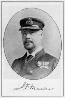
John Fiot Lee Pearse Maclear was an admiral in the Royal Navy, known for his leadership in hydrography.

The Nuyts Archipelago is an island group located in South Australia in the Great Australian Bight to the south of the town of Ceduna on the west coast of the Eyre Peninsula. It consisting of mostly granitic islands and reefs that provide breeding sites for Australian sea lions and support colonies of short-tailed shearwater. It also includes the island group known as the Isles of St Francis. All the islands with exception of a part of Evans Island, are located with the following protected areas - the Nuyts Archipelago Wilderness Protection Area and the Nuyts Archipelago Conservation Park.
Little Island is an island in the Australian state of South Australia located in Spencer Gulf off the east coast of Jussieu Peninsula on Eyre Peninsula approximately 28 kilometres (17 mi) south-east of Port Lincoln. It was named by Matthew Flinders in memory of John Little who was one of the eight crew lost from a cutter that capsized sometime after being launched from HM Sloop Investigator to search for water on 21 February 1802. Since 2004, the island has been part of the Memory Cove Wilderness Protection Area.
Topgallant Islands is an island group in the Australian state of South Australia located in the Investigator Group about 22 kilometres south west of Cape Finniss on the west coast of Eyre Peninsula. The group was discovered and named by Matthew Flinders on 13 February 1802. The island group has enjoyed protected area status since the 1960s and since 2011, it has been part of the Investigator Group Wilderness Protection Area.

Flinders Chase is a locality in the Australian state of South Australia located on the south-western coast of Kangaroo Island overlooking the body of water known in Australia as the Southern Ocean and by international authorities as the Great Australian Bight. It is located about 210 kilometres south-west of the state capital of Adelaide.

.
References
- ↑ "Australian Government, Geoscience Australia". Archived from the original on 4 August 2012.
| | This Queensland protected areas related article is a stub. You can help Wikipedia by expanding it. |