
Ayeyarwady Region is a region of Myanmar, occupying the delta region of the Ayeyarwady River. It is bordered by the Rakhine State to the northwest, the Bago Region to the north, Bago Region and Yangon Region to the east, and the Bay of Bengal to the south and west.

Magway Region is an administrative division in central Myanmar. It is the second largest of Myanmar's seven divisions, with an area of 44,820 km2. Pa Del Dam (ပဒဲဆည်) is one of the dams in Aunglan Township, Magway Division. The capital and second largest city of the Magway Division is Magway. The largest city is Pakokku. The major cities of Magway Division are Magway, Pakokku, Aunglan, Yenangyaung, Taungdwingyi, Chauk, Minbu, Thayet and Gangaw.
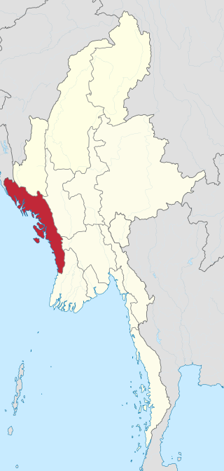
Rakhine State, formerly known as Arakan State, is a state in Myanmar (Burma). Situated on the western coast, it is bordered by Chin State to the north, Magway Region, Bago Region and Ayeyarwady Region to the east, the Bay of Bengal to the west and the Chittagong Division of Bangladesh to the northwest. It is located approximately between latitudes 17°30' north and 21°30' north and longitudes 92°10' east and 94°50' east. The Arakan Mountains or Rakhine Yoma separated Rakhine State from central Burma from North to South. Off the coast of Rakhine State there are some fairly large islands such as Ramree, Cheduba and Myingun. Rakhine State has an area of 36,762 square kilometres (14,194 sq mi) and its capital is Sittwe.

Myanmar is divided into 21 administrative divisions, which include seven regions, seven states, one union territory, one self-administered division, and five self-administered zones.

Pathein Township is a township of Pathein District in the Ayeyawady Region of Myanmar. The administrative seat of the Township, District and Region is Pathein. The city of Pathein is the largest city in the Region and has historically been an important center of trade, including a deepwater port.
Pathein District is a district of Ayeyawady Division, Myanmar. It is located around and includes the urban area of the city of Pathein. The area of the Pathein District is 10,899.8 km2 (4,208.4 sq mi). Its population was 1,630,716 in 2014.

Ngapudaw Township or Ngaputaw Township is a township of Pathein District in the Ayeyarwady Region of Myanmar. The western portion of the township includes Ngayokaung Subtownship and the southern portion of the township includes Hainggyikyun Subtownship, both unofficial divisions used by the Township for statistical and administrative ease. The small village of Kyounku within Hainggyikyun Subtownship is the birthplace of former President of Myanmar Thein Sein.

Yegyi Township is a township of Kyonpyaw District in north-central Ayeyarwady Region, Myanmar. The Township has three towns- the principal town of Yekyi and the towns of Ahthoke, Ngathaingchaung. The western portion of the township are informally includes Ngathaingchaung Subtownship, an unofficial division used by the Township for statistical and administrative ease. The township as a whole borders Lemyethna Township of Hinthada District to the north, Gwa Township of Rakhine State to the northwest and Thabaung Township of Pathein District to the southwest. To its east and southeast, it borders the other two townships of Kyonpyaw District, Kyonpyaw Township and Kyaunggon Township.

Thabaung Township is a township of Pathein District in the Ayeyarwady Region of Myanmar. The principal town is Thabaung.

Kyainseikgyi Township is a township of Kyainn Seikkyi District in the Kayin State of Myanmar. It is the fourth-biggest township in Kayin State. The two main sub-towns are Kyeikdon and Payathonsu. It is drained by the Zami, Winyaw and the Haungtharaw rivers.
Taungup, Toungup, or Taunggoke is the principal town of the Taungup Township and Taunggup District in Rakhine State, western Myanmar. In 2014, the town had a population of 28,652. In 2019, the population was lower at only 26,854 people.

Thandwe District is a district of Rakhine State in western Myanmar. The capital is Thandwe. As of 2015 it had a population of 357,840.

Manaung is a township of Taungup District in south-central Rakhine State, western Myanmar. The principal town is Manaung. Manaung Township, situated on Manaung Island, consists of three islands: Manaung Island, Ye Kyun Island and Taik Kyun Island. Manaung is not only a township but also the second biggest island of Rakhine State in Myanmar.

Taungup Township is a coastal township of Taungup District in the Rakhine State of Myanmar. The town is Taungup. The township has three towns, the principal town Taungup, Ma-Ei and Thanlwe Ywama, comprising a total of 14 urban wards as well as 52 village tracts grouping together 203 villages.
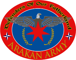
The Arakan Army, sometimes referred to as the Arakha Army, is an ethno-nationalist armed organisation based in Rakhine State (Arakan). Founded in April 2009, the AA is the military wing of the United League of Arakan (ULA). It is currently led by Commander-in-Chief Major General Twan Mrat Naing and vice deputy commander-in-chief Brigadier General Nyo Twan Awng. It is the military wing of the Rakhine ethnic people in Rakhine state where they are the majority. They seek greater autonomy from the Myanmar's central government and wants to restore the sovereignty of Arakan people. It was declared a terrorist organization in 2020 by Myanmar, and again by the State Administration Council junta in 2024.
Ngathaingchaung or Ngathinechaung and sometimes Ngathainggyaung is a town and the second largest town in Yegyi Township, Kyonpyaw District in north-central Ayeyarwady Region, Myanmar and is divided into 6 urban wards. It is the namesake of Ngathaingchaung Subtownship, an informal division sued for statistical and administrative convenience. As such, it is the administrative seat for some local functions for 31 village tracts, which group together 196 of Yegyi Township's western half.
Kyeintali Subtownship is divided from Gwa Township, Rakhine State. Government offices of Kyeintali Subtownship are located in Kyeintali

Shwethaungyan Subtownship, also spaced out as Shwe Thaung Yan, is a subtownship in Pathein District, Ayeyarwady Region, Myanmar. The subtownship is split between Pathein Township and Thabaung Township; it has a total area of 178.50 square miles (462.3 km2), with 153.16 square miles (396.7 km2) in Pathein and 25.34 square miles (65.6 km2) in Thabaung.

Ngathaingchaung Subtownship is a subtownship of Yekyi Township in Kyonpyaw District, Ayeyarwady Region, Myanmar. It can also sometimes be referred to simply as Ngathaingchaung Township. The namesake of the subtownship is Ngathaingchaung, a town of 18,621 people. The subtownship is located partially on the Irrawaddy Delta and partially over the southern Arakan Mountains.

Taungup District is a district of Rakhine State in western Myanmar. The capital is Taungup. The District was designated in 2022, splitting off parts of Thandwe District and Kyaukphyu District.


