Jema'a is a Local Government Area in southern Kaduna State, Nigeria with headquarters at Kafanchan. The Local Government Council is chaired by Yunana Barde. It has an area of 1,384 km2 and a population of 278,202 at the 2006 census. The postal code of the area is 801.
Kaura is a town and a Local Government Area in southern Kaduna State, Nigeria. Its headquarters are in the town of Kaura in Asholyio (Moroa) Chiefdom. The Local Government Council is chaired by Matthias Siman. Other towns include: Manchok and Kagoro. It has an area of 461 km2 and a population of 174,626 at the 2006 census. The postal code of the area is 801.
Kachia Hausa Fulani and Kadara and Jaba is a Local Government Area in the southern part of Kaduna State, Nigeria. Its headquarters are in the town of Kachia. It has an area of 4,570 km2 and a population of 252,568 in the 2006 census. The postal code of the area is 802.
Zangon Kataf is a Local Government Area in southern Kaduna State, Nigeria. Its headquarters is in the town of Zonkwa. It is also a name of a town in the chiefdom of the Atyap. Other towns include: Batadon (Madakiya), Cenkwon, Kamantan, Anchuna Sarki and Kamuru. It has an area of 2,579 km2 and a population of 318,991 at the 2006 census. The postal code of the area is 802.
Kauru is a Local Government Area in southern Kaduna State, Nigeria. The area is 3,186 km2. Its headquarters are in the town of Kauru. The postal code of the area is 811.
Gworok, also known as Gworog, is a large town in southern Kaduna State, Middle Belt Nigeria. It is located in the Kaura Local Government Area. Gworok is a Christian-dominated town. It is home to many missionaries, attracted by the cool weather and relatively high altitude. Gworog has a post office. Other places in Kagoro are Malagum and Tum.
The Atyap people are an ethnic group found majorly in Zangon-Kataf, Kaura and Jema'a Local Government Areas of southern Kaduna State, Nigeria. They speak the Tyap language, one of the Central Plateau languages.
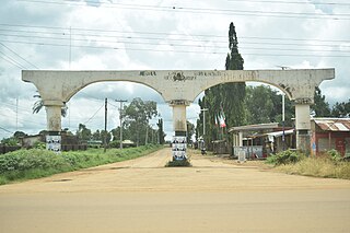
Zonkwa is the Zangon Kataf Local Government Area as well as the Bajju Chiefdom headquarters, in southern Kaduna state in the Middle Belt region of Nigeria.
Atyap Chiefdom is a Nigerian traditional state of the Atyap people, located on the upper Kaduna River basin of the central Nigeria plateau in the Middle Belt. Its headquarters is at A̠tak Njei, Zangon Kataf, southern Kaduna state, Nigeria.
Bala Ade Dauke Gora was the first indigenous District Head in Southern Zaria and first monarch of the Atyap Chiefdom, a Nigerian traditional state in southern Kaduna State, Middle Belt (central) Nigeria. He was known by the titles Kuyan Banan Zazzau and Agwatyab I.
The genesis of the 1992 Zangon Kataf Crises could at least be traced to the onset of the British imperial regime in the Northern Region of Nigeria, in which the Atyap people began reporting loss of a land to the Hausas. In 1922, it was reported that a large piece of land was acquired by the Emir of Zaria, Dalhatu Uthman Yero, who failed to compensate the indigenous population of the region. In 1966, the land was provided to the Hausa trading settlement in the heart of Mabatado, called "Zangon Kataf", by the emir, Muhammad Usman. The Atyap resided within the district, in the Zaria Province of the Northern Region of, initially, British Nigeria, which became independent Nigeria. It was to remain utilized as a marketplace, where the indigenous Atyap people were banned from trading pork and beer by the settlers.
The Āsholiō tribe of the Sholiō land are located in Sholiō Chiefdom, comprising Tsōk (Manchok), Āzankan (Zankan), Āzagwai (Gizagwai), Bondong, Vak (Kajim) among other districts and villages in Kaura Local Government Area. The people are known as Sholiō, while the language they speak is Āsholiō. They are one of three chiefdoms in the local government. And they have a 1st Class Chief, in southern Kaduna state in the Middle Belt region of Nigeria.
Cenkwon is a town in Jei District of Zangon Kataf Local Government Area in southern Kaduna state in the Middle Belt region of Nigeria. The postal code of the area is 802.
Kamuru is a town in Zangon Kataf Local Government Area in southern Kaduna state in the Middle Belt region of Nigeria. It is the headquarters of the Akulu chiefdom. The postal code of the area is 802.
Ashong Ashyui (Jankasa) is a village community in Jei District of Zangon Kataf Local Government Area, southern Kaduna state in the Middle Belt region of Nigeria. The postal code for the village is 802141. The area has an altitude of about 2,798 feet or 852 meters and a population of about 7,837. The nearest airport to the community is the Yakubu Gowon Airport, Jos.
Kanai is a district as well as a village in Zangon Kataf Local Government Area of southern Kaduna state in the Middle Belt region of Nigeria. The postal code of the area is 802139.
Bafoi is a village in Kanai district of Zangon Kataf Local Government Area in southern Kaduna state in the Middle Belt region of Nigeria. The postal code of the area is 802145.
Zonzon is a district and a village community in Zangon Kataf Local Government Area, southern Kaduna state in the Middle Belt region of Nigeria. The postal code for the area is 802138.
Jei is district of Zangon Kataf Local Government Area, southern Kaduna state in the Middle Belt region of Nigeria. The postal code for the area is 802130.
Atak Nfang is a district and a village community in Zangon Kataf Local Government Area, southern Kaduna state in the Middle Belt region of Nigeria. The postal code for the area is 802142.
