Related Research Articles

Apache County is in the northeast corner of the U.S. state of Arizona. Shaped in a long rectangle running north to south, as of the 2020 census, its population was 66,021. The county seat is St. Johns.

Sandoval County is located in the U.S. state of New Mexico. As of the 2020 census, the population was 148,834, making it the fourth-most populous county in New Mexico. The county seat is Bernalillo.
Fort Defiance is a census-designated place (CDP) in Apache County, Arizona, United States. It is also located within the Navajo Nation. The population was 3,624 at the 2010 census.
Window Rock is a census-designated place that serves as the seat of government and capital of the Navajo Nation, the largest territory in North America of a sovereign Native American nation. The capital lies within the boundaries of the St. Michaels Chapter, adjacent to the Arizona and New Mexico state line. Window Rock is the site of the Navajo Nation governmental campus, which contains the Navajo Nation Council, Navajo Nation Supreme Court, the offices of the Navajo Nation President and Vice President, and many Navajo government buildings.
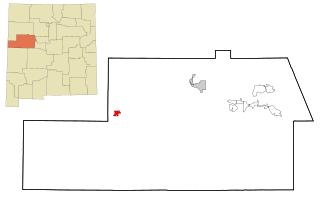
Pinehill or Pine Hill is a census-designated place in Cibola County, New Mexico, United States. It is located on the Ramah Navajo Indian Reservation. The population was 88 at the 2010 census. The location of the CDP in 2010 had become the location of the Mountain View CDP as of the 2020 census, while a new CDP named "Pinehill" was listed 8 miles (13 km) further south, at a point 4 miles (6 km) southeast of Candy Kitchen.

Crownpoint is a census-designated place (CDP) on the Navajo Nation in McKinley County, New Mexico. The population was 2,500 at the time of the 2010 census. It is located along the Trails of the Ancients Byway, one of the designated New Mexico Scenic Byways.
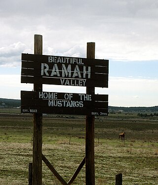
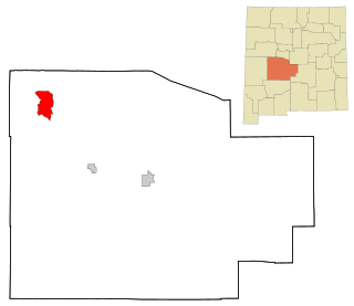
Ramah is a census-designated place (CDP) in McKinley County, New Mexico. The population was 407 at the time of 2000 census and 370 at the 2010 United States Census.

Tohatchi is a census-designated place (CDP) in McKinley County, New Mexico, United States. It is known as a health-services and education hub along Highway 491. Its population was reported to be 785 at the 2020 census. As Tohatchi is located on the Navajo Nation, it is designated federal trust land.

Farmington is a city in San Juan County in the U.S. state of New Mexico. As of the 2020 census the city had a total population of 46,624 people. Farmington makes up one of the four Metropolitan Statistical Areas (MSAs) in New Mexico.

Shiprock is an unincorporated community on the Navajo reservation in San Juan County, New Mexico, United States. The population was 7,718 people in the 2020 census. For statistical purposes, the United States Census Bureau has defined Shiprock as a census-designated place (CDP). It is part of the Farmington Metropolitan Statistical Area.
Alamo is a census-designated place (CDP) in Socorro County, New Mexico, United States. The population was 1,085 at the 2010 census. It is the largest community on the Alamo Navajo Indian Reservation.

Crystal is a census-designated place (CDP) on the Navajo Nation in McKinley and San Juan counties in New Mexico, United States. The population was 311 at the 2010 census. It is located at the western end of the Narbona Pass.

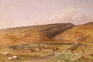
The Ramah Navajo Indian Reservation is a non-contiguous section of the Navajo Nation lying in parts of west-central Cibola and southern McKinley counties in New Mexico, United States, just east and southeast of the Zuni Indian Reservation. It has a land area of 230.675 sq mi (597.445 km²), over 95 percent of which is designated as off-reservation trust land. According to the 2000 census, the resident population is 2,167 persons. The Ramah Reservation's land area is less than one percent of the Navajo Nation's total area.
The Alamo Navajo Indian Reservation is a non-contiguous section of the Navajo Nation lying in northwestern Socorro County, New Mexico, United States, adjacent to the southeastern part of the Acoma Indian Reservation. It has a land area of 256.616 km², and a 2000 census resident population of almost 2,000 persons. The Alamo Band of the Navajo Nation Reservation's land area is only about four-tenths of one percent of the Navajo Nation's total area. The remote community has a K-12 school, Early Childhood Center, Wellness Center, a Community Service center that provides school and non-school related programs, a state-of-the-art Health Center and KABR radio, 1500 AM.
Gallup-McKinley County Schools (GMCS) is a school district based in Gallup, New Mexico which serves students from Gallup and surrounding areas of McKinley County.

The Bureau of Indian Education (BIE), headquartered in the Main Interior Building in Washington, D.C., and formerly known as the Office of Indian Education Programs (OIEP), is a division of the U.S. Department of the Interior under the Assistant Secretary for Indian Affairs. It is responsible for the line direction and management of all BIE education functions, including the formation of policies and procedures, the supervision of all program activities, and the approval of the expenditure of funds appropriated for BIE education functions.
Pine Hill Schools is a K-12 tribal school system operated by the Ramah Navajo School Board, Inc. (RNSB), in association with the Bureau of Indian Education (BIE), in Pine Hill, New Mexico.
Alamo Navajo School Board, Inc. (ANSB) refers to the entity controlling a K-12 tribal school in Alamo, New Mexico. It is affiliated with the Bureau of Indian Affairs (BIA). It also maintains a clinic and other public infrastructure in Alamo.
Ramah Middle/High School is a public secondary school in unincorporated McKinley County, New Mexico, near the Ramah census-designated place and with a Ramah postal address. It is a part of Gallup-McKinley County Schools.
References
- ↑ "2020 CENSUS - SCHOOL DISTRICT REFERENCE MAP: Socorro County, NM" (PDF). U.S. Census Bureau . Retrieved 2021-04-27.
- ↑ "About the Alamo Navajo School Board". Alamo Navajo School Board. Retrieved 2021-04-27.
- ↑ Larson, John (2020-06-30). "Mag superintendent entering new territory". El Defensor Chieftain . Retrieved 2021-04-27.