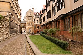
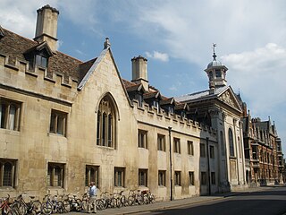
Corpus Christi College is one of the constituent colleges of the University of Oxford in the United Kingdom. Founded in 1517, it is the 12th oldest college in Oxford.

Merton College is one of the constituent colleges of the University of Oxford in England. Its foundation can be traced back to the 1260s when Walter de Merton, chancellor to Henry III and later to Edward I, first drew up statutes for an independent academic community and established endowments to support it. An important feature of de Merton's foundation was that this "college" was to be self-governing and the endowments were directly vested in the Warden and Fellows.

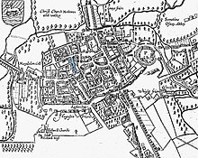
Christ Church Meadow is a flood-meadow and popular walking and picnic spot in Oxford, England.

Mob Quad is a four-sided group of buildings from the 13th and 14th centuries in Merton College, Oxford, surrounding a small lawn. It is often claimed to be the oldest quadrangle in Oxford and elsewhere, although Merton's own Front Quad was actually enclosed earlier and Corpus Christi College, Cambridge, says that its own Old Court is the oldest structure of its type in either Oxford or Cambridge. The quadrangle pattern has since been copied at many other colleges and universities worldwide.

The Radcliffe Quadrangle is the second quadrangle of University College, Oxford, England. The buildings have been Grade I listed since 1954.
Logic Lane is a small historic cobbled lane that runs through University College in Oxford, England, so called because it was the location of a school of logicians. It links the High Street at the front of the college with Merton Street to the rear, which is also cobbled. Logic Lane covered bridge is a short covered bridge over the lane at the High Street end. To the west of the lane are the Radcliffe Quad and the Master's Lodgings. To the east are the 1903 Durham Buildings and the Goodhart Quad. The lane is locked at night, with gates at each end. It is mainly used by pedestrians, but vehicular access is possible.

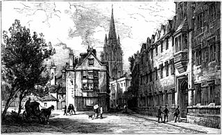
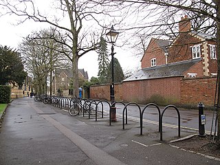
Merton Street is a historic and picturesque cobbled street in central Oxford, England. It joins the High Street at its northeastern end, between the Ruskin School of Drawing and Fine Art and the Eastgate Hotel at the historic east gate of the city. It then runs east–west, parallel and to the south of the High Street for most of its length.

Alfred Street is a street running between the High Street to the north and the junction with Blue Boar Street and Bear Lane at the southern end, in central Oxford, England. To the south is Christ Church, one of Oxford University's historic colleges.
Oriel Street is a narrow but historic street running between the High Street to the north and Oriel Square to the south in central Oxford, England. The street is now blocked off to traffic by bollards at the High Street end.
Queen's Lane is a historic street in central Oxford, England, named after Queen's College, to the south and west. St Edmund Hall, a constituent college of the University of Oxford, is located on the southern end of this street.

Burwood Park is an historic estate in the parish of Hersham in Surrey, England. The old mansion house has been demolished and much of the parkland built over to form approximately 400 large detached houses dating from the early 20th century to the present day. The new estate's roads are of a geometric design within an approximate semicircle and many of its roads have entrances with automatic bollards or security buildings.

New Inn Hall Street is a street in central Oxford, England, and is one of Oxford's oldest streets. It is a shopping street running north–south parallel and to the west of Cornmarket Street, with George Street to the north and Bonn Square at the west end of Queen Street to the south. St Michael's Street leads off the street to the east near the northern end. Shoe Lane to the east leads to the Clarendon Centre, a modern shopping centre.

Amen Corner is a street located off Ave Maria Lane, just to the west of St. Paul's Cathedral and between the Old Bailey and Paternoster Square, in the City of London.
Pullens Lane is in Headington, east Oxford, England. It is located at the top of Headington Hill, leading north off Headington Road to Jack Straw's Lane and Harberton Mead. The cul-de-sac Pullens Field leads off west from Pullens Lane.
Jowett Walk is a road in central Oxford, England. It connects Mansfield Road to the west with St Cross Road to the east, running parallel with and north of Holywell Street.

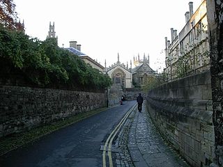
Dead Man's Walk is a footpath running east–west in central Oxford, England, situated immediately to the south of Merton College and just outside the old city wall, with Corpus Christi College at the western end. To the north, Grove Walk connects with Merton Street through a gateway. Immediately to the south is Merton Field with Merton Walk connecting to the wide tree-lined Broad Walk, which runs parallel with Dead Man's Walk. Beyond that is Christ Church Meadow.
Trumpington Street is a major historic street in central Cambridge, England. At the north end it continues as King's Parade where King's College is located. To the south it continues as Trumpington Road, an arterial route out of Cambridge, at the junction with Lensfield Road.

Bene't Street is a short, historic street in central Cambridge, England, the name being derived from St Benedict. There is a junction with King's Parade to the north and Trumpington Street to the south at the western end of the street. Free School Lane leads off to the south. To the east, the street continues as Wheeler Street.

Merton Field is a grass playing field north of the main part of Christ Church Meadow and south of Merton College in central Oxford, England.

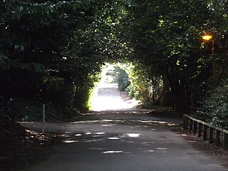
Grove Walk is a short historic leafy walkway running north–south in central Oxford, England, situated on land between Merton College to the east and Corpus Christi College to the west. It provides one of the entrances to Christ Church Meadow from the north.