This article has multiple issues. Please help improve it or discuss these issues on the talk page . (Learn how and when to remove these messages)
|
Mahog Mahog | |
|---|---|
village | |
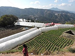 Polyhouse Floriculture in village Mahog | |
 Mahog Location in Himachal Pradesh, India  Mahog Mahog (India) | |
| Coordinates: 30°34′52″N77°06′45″E / 30.5810°N 77.1125°E | |
| Country | |
| State | Himachal Pradesh |
| District | Solan |
| Government | |
| • Body | Panchayat |
| Languages | |
| • Official | Hindi |
| • Native | Baghati |
| Time zone | UTC+5:30 (IST) |
| Nearest city | Chail |
| Civic agency | Panchayat |
Mahog is a tiny village in the Solan district of Himachal Pradesh, India. [1] It has a population of around 50.[ citation needed ] It is around five kilometers from Chail on the Kandaghat road. The village is known for its floriculture, with many hi-tech floriculture polyhouse farms located in the village.


