This article needs additional citations for verification .(November 2024) |
Maidan, or Tirah Maidan, is a remote valley located in the Tirah region in Khyber Agency, Pakistan.
This article needs additional citations for verification .(November 2024) |
Maidan, or Tirah Maidan, is a remote valley located in the Tirah region in Khyber Agency, Pakistan.
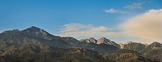
Maidan lies at an elevation of about 7,400 ft (2,300 m), close under the snow-bound Spin Ghar mountain range, which separates it from the Shinwar area of Nangarhar, Afghanistan. It is drained by a narrow outlet which joins the Bara River. [1] Despite the sloping plateau, Tirah is highly cultivated by terracing. There are walnut trees, mulberry and apricot, as well as wild olives and occasional pomegranates, and blue pine covers the summits. But on the whole, Maidan is sparsely wooded. [1]
Afridis migrate to the pleasant heights of Maidan in summer from lower altitude areas like the Bara Valley. The Saran Sar Pass at (8,650 ft) connects Maidan with the Bara Valley. The Tseri Kandao Pass (8,575 ft) connects Maidan with the Waran Valley to the east, and the Arhanga Pass (7,050 ft) connects Maidan with the Mastura Valley to the south. The Rajgul Valley lies to the northwest, between Maidan and the Spin Ghar mountain range.

The Sulaiman Mountains, also known as Kōh-e Sulaymān or Da Kasē Ghrūna, are a north–south extension of the southern Hindu Kush mountain system in Pakistan and Afghanistan. They are also known as Aparanchal Range, or Western Mountains ; as they mark the westernmost boundary of the Indian Subcontinent. They rise to form the eastern edge of the Iranian plateau. They are located in the Kandahar, Zabul and Paktia provinces of Afghanistan, and in Pakistan they extend over the northern part of Balochistan and Waziristan as well as Kurram of Khyber Pakhtunkhwa. In southwestern Punjab, the mountains extend into the two districts of Dera Ghazi Khan and Rajanpur, which are located west of the Indus River on the boundary with Balochistan. Bordering the mountains to the east are the plains of the Indus River valley, and to the north are the arid highlands of the Central Hindu Kush whose heights extend up to 3,383 metres (11,099 ft). The total area on which this range spans around 6475 sq. km. Together with the Kirthar Mountains on the border between Balochistan and Sindh, the Sulaiman Mountains form what is known as the Sulaiman-Kirthar geologic province.

The Shinwari are an ethnic Pashtun tribe of Afghanistan and Pakistan. Among the greatest poets of the Pashto language in the 20th century was the late Ameer Hamza Shinwari, also known as "Hamza Baba".

The Afrīdī are a Pashtun tribe present mostly in tribal areas in Khyber Pakhtunkhwa, Pakistan.
Lanḍī Kōtal or Lwargai is a town in the Province of Khyber Pakhtunkhwa in Pakistan, and the administrative capital of Khyber District. It was one of the largest towns in the former Federally Administered Tribal Areas, and is located 1,072 metres (3,517 ft) above sea level, on the route across the mountains to the city of Peshawar. Landi Kotal is at the western edge of the Khyber Pass that marks the entrance to the Nangarhar Province of Afghanistan, which is located just 5 kilometres (3 mi) to the west.

The Tirah campaign, often referred to in contemporary British accounts as the Tirah expedition, was an Indian frontier campaign from September 1897 to April 1898. Tirah is a mountainous tract of country in what was formerly known as Federally Administered Tribal Areas of Pakistan, now Khyber Pakhtunkhwa province.
The Spīn Ghar or Safēd Kōh meaning both White Mountains, or sometimes meaning white mountain range, is a mountain range to the south of the Hindu Kush. It ranges from eastern Afghanistan into Khyber Pakhtunkhwa, Pakistan, and forms a natural border between the two areas. Its highest peak is Mount Sikaram on the Afghanistan–Pakistan border, which towers above all surrounding hills to 4,755 m (15,600 ft) above mean sea level. The lower hills are mostly barren and treeless, but pine grows on the main mountains that form the East Afghan montane conifer forests.

Tirah, also spelled Terah, also called the Tirah Valley, is a mountainous region located in the Orakzai District and the southern part of the Khyber District, positioned between the Khyber Pass and the Khanki Valley in Pakistan. Due to its proximity to the Afghan-Pakistan border and challenging terrain, maintaining control of Tirah has been historically difficult for the Government of Pakistan. In 2003, for the first time since Pakistan's independence, the Army entered the Tirah Valley.
The Samana Range is a mountain ridge in the Hangu District of the Khyber Pakhtunkhwa of Pakistan, commanding the southern boundary of Tirah. The ridge lies between the Khanki Valley on the north and the Miranzai Valley on the south, and extends for some 30 m. west from Hangu to the Samana Suk. It is some 6000 to 7000 ft. high.

Khyber District is a district in the Peshawar Division of the Khyber Pakhtunkhwa province of Pakistan. Until 2018, it was an agency of the erstwhile Federally Administered Tribal Areas. With the merger of FATA with Khyber Pakhtunkhwa in 2018, it became a district. It ranges from the Tirah valley down to Peshawar. It borders Nangarhar Province to the west, Orakzai District to the south, Kurram District to southwest, Peshawar to the east and Mohmand District to the north.
The Orakzai are a Pashtun tribe native to the Orakzai Agency and parts of Kurram and Khyber Agencies in Pakistan's Khyber Pakhtunkhwa province. Additionally, a sub-tribe of the Orakzai resides in Afghanistan's Maidan Wardak Province. The Orakzai people predominantly speak Pashto.
Kohat Division is one of the seven divisions in the Khyber Pakhtunkhwa province of Pakistan. It consists of five districts: Hangu, Karak, Kohat, Kurram, and Orakzai. The division borders Bannu Division to the south and west, Peshawar Division to the north and east, the province of Punjab to the east, and Afghanistan to the northwest. CNIC code of Kohat Division is 14.

Mount Sikaram is a mountain on the Afghanistan–Pakistan border, south of the Kabul River and Khyber Pass. At 4,755 m (15,600 ft), it is the highest peak of the Spīn Ghar, or Safēd Kōh, mountain range.
Bara River is a river in Khyber District of Khyber Pakhtunkhwa province in Pakistan. The Bara River originates in the Tirah Valley of Bara Tehsil, Khyber district. It joins the Kabul River Canal which originates from the Warsak Dam, and re-enters Peshawar. Then it flows in a north-easterly direction to the Nowshera District, eventually joining the Kabul River near Camp Koruna, Akbarpura. Due to its higher elevation, very limited areas flow through gravity into Bara river.

The Khyber Pass is a mountain pass in the Khyber Pakhtunkhwa province of Pakistan, on the border with the Nangarhar Province of Afghanistan. It connects the town of Landi Kotal to the Valley of Peshawar at Jamrud by traversing part of the White Mountains. Since it was part of the ancient Silk Road, it has been a vital trade route between Central Asia and the Indian subcontinent and a strategic military choke point for various states that controlled it. The Khyber Pass is considered one of the most famous mountain passes in the world.
The Chamkani, is a sub-tribe of Ghoryakhel Pashtuns. According to Muhammad Hayat Khan, author of Hayat-i-Afghani Chamkani are descendants of Ibrahim Ghoria. They are also related to Mohmand, Daudzai and Khalil through their Sarbani descent.
The Black Mountain (Tor Ghar), is located in the Hazara Division of the Khyber Pakhtunkhwa province of Pakistan. Tor Ghar is a Pashto phrase which means Black (Tor) Mountain (Ghar). It is also called Kala Dhaka, which means the same as its Pushto name; in Hindko a local language spoken by the people of Tanawal and Agror which are located on eastern side of Tor Ghar. Tor Ghar lies to the east of the River Indus from Thakot to Darband. The total length of this mountain is about twenty five to thirty miles and its average height about 8,000 feet (2,400 m) feet above sea level. Machai Sar is the highest peak, which is 9,817 ft (2,992 m) above sea level. It ascends from the River Indus basin at its southern end near the village of Kiara and goes up to its watershed near the village Baradar; then it runs north-east by north to the point on the crest known as Chitabat. From here the range runs due north, finally descending to the Indus by two large spurs, at the foot of the easternmost of which lies Thakot. The Indus, after passing Thakot, turns westward along the northern foot of the mountain until it washes the western of the two aforementioned spurs, when it takes a sharp bend to the south, and runs below and parallel to the western foot of this mountain range.
Bara Dam is a proposed small, low-head, earth core rockfill, hydroelectric dam with a capacity of 5.8 megawatts, located across Bara River at the confluence of Mastura River in Tirah Valley, Khyber Agency, FATA, Pakistan. It is part of a wider plan that consists in remodeling the Bara River, to promote agriculture.

Khyber was the code-name for a 2014–2017 military offensive conducted by Pakistan's military in the Khyber Agency in four phases; Khyber-1, Khyber-2, Khyber-3 and Khyber-4.
The Afridi Redshirt Rebellion was a military campaign conducted by British Indian Army against Afridi tribesmen Ajab Khan Afridi in the North West Frontier region of the Indian Empire, now in Pakistan in 1930–1931.

The Baluchistan xeric woodlands ecoregion covers the middle elevations of a series of mountain ranges of western Pakistan and northeastern Afghanistan, reaching 1,200 kilometres (750 mi) from the Arabian Sea in the south to the Hindu Kush Mountains and the Himalayas in the north. The characteristic vegetation is xeric (dry) woodlands of shrubs and herbaceous cover. The region has rich biodiversity but relatively few endemic species.