Jacques Cartier was a French-Breton maritime explorer for France. Jacques Cartier was the first European to describe and map the Gulf of Saint Lawrence and the shores of the Saint Lawrence River, which he named "The Country of Canadas" after the Iroquoian names for the two big settlements he saw at Stadacona and at Hochelaga.
Longueuil is a city in the province of Quebec, Canada. It is the seat of the Montérégie administrative region and the central city of the urban agglomeration of Longueuil. It sits on the south shore of the Saint Lawrence River directly across from Montreal. The population as of the Canada 2021 Census totalled 254,483, making it Montreal's second largest suburb, the fifth most populous city in Quebec and twentieth largest in Canada.

Les Îles-de-la-Madeleine is a municipality located in Gaspésie-Îles-de-la-Madeleine region, in Quebec, Canada. It is located on the islands of the Magdalen Islands archipelago, in the Gulf of St. Lawrence, 250 km (160 mi) from Gaspé, 120 km (75 mi) from Prince Edward Island, 90 km (56 mi) from Cape Breton Island, and 150 km (93 mi) from Newfoundland.
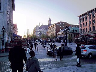
Place Jacques-Cartier is a square located in Old Montreal, Quebec, Canada. It is an entrance to the Old Port of Montreal.

Ville-Marie is the name of a borough (arrondissement) in the centre of Montreal, Quebec. The borough is named after Fort Ville-Marie, the French settlement that would later become Montreal, which was located within the present-day borough. Old Montreal is a National Historic Site of Canada.

Hochelaga was a St. Lawrence Iroquois 16th century fortified village on or near Mount Royal in present-day Montreal, Quebec, Canada. Jacques Cartier arrived by boat on October 2, 1535; he visited the village on the following day. He was greeted well by the Iroquois, and named the mountain he saw nearby Mount Royal. Several names in and around Montreal and the Hochelaga Archipelago can be traced back to him.

Old Montreal is a historic neighbourhood within the municipality of Montreal in the province of Quebec, Canada. Home to the Old Port of Montreal, the neighbourhood is bordered on the west by McGill Street, on the north by Ruelle des Fortifications, on the east by rue Saint-André, and on the south by the Saint Lawrence River. Following recent amendments, the neighbourhood has expanded to include the Rue des Soeurs Grises in the west, Saint Antoine Street in the north, and Saint Hubert Street in the east.

The five-story Montreal City Hall is the seat of local government in Montreal, Quebec, Canada. It was designed by architects Henri-Maurice Perrault and Alexander Cowper Hutchison, and built between 1872 and 1878 in the Second Empire style. It is located in Old Montreal, between Place Jacques-Cartier and the Champ de Mars, at 275 Notre-Dame Street East. The closest Metro station is Champ-de-Mars, on the Orange Line.

Jacques-Cartier Park is a park in Gatineau, Quebec, Canada, along the Ottawa River. The park is more than 22.68 hectares large and is located at the base of the Alexandra Bridge, facing the National Gallery of Canada in Ottawa. It is named for French explorer Jacques Cartier, who arrived at the mouth of the Ottawa River while he was looking for the Northwest Passage.

The Pied-du-Courant Prison is a prison museum in Montreal, Quebec, Canada near the Saint Lawrence River and the Jacques-Cartier Bridge.

Sherbrooke Street is a major east–west artery and at 31.3 kilometres (19.4 mi) in length, is the second longest street on the Island of Montreal, Canada. The street begins in the town of Montreal West and ends on the extreme tip of the island in Pointe-aux-Trembles, intersecting Gouin Boulevard and joining up with Notre-Dame Street. East of Cavendish Boulevard this road is part of Quebec Route 138.

The Maison Saint-Gabriel Museum is located in Montreal, Quebec and is dedicated to preserving the history, heritage and artifacts of the settlers of New France in the mid 17th century. The museum consists of a small farm, which has been administered for more than 300 years by the Sisters of the Congregation of Notre Dame of Montreal, founded by Marguerite Bourgeoys in Montreal in 1658.

Jacques-Cartier National Park is a provincial park located 50 kilometres (31 mi) north of Quebec City. The park aims to protect wildlife in the Laurentian massif. It lies within the Eastern forest-boreal transition ecoregion.

The Centre-Sud is a neighbourhood located in the easternmost edge of the Ville-Marie borough of the city of Montreal.

Nelson's Column is a monument, designed by Scottish architect Robert Mitchell and erected in 1809 in Place Jacques-Cartier, Montreal, Quebec, Canada, which is dedicated to the memory of Admiral Horatio Nelson, following his death at the Battle of Trafalgar. Subsequent to the destruction of Nelson's Pillar in Dublin (1808–1966), Montreal's pillar now stands as the second-oldest "Nelson's Column" in the world, after the Nelson Monument in Glasgow. It is also the city's oldest monument and is the oldest war monument in Canada.

Fort Ville-Marie was a French fortress and settlement established in May 1642 by a company of French settlers, led by Paul de Chomedey de Maisonneuve, on the Island of Montreal in the Saint Lawrence River at the confluence of the Ottawa River, in what is today the province of Quebec, Canada. Its name is French for "City of Mary", a reference to the Blessed Virgin Mary.

Cartier-Brébeuf National Historic Site is a National Historic Site of Canada and so designated by the Historic Sites and Monuments board of Canada in 1958 under the recommendation of John Diefenbaker, the Prime Minister of Canada at the time. It is administered by Parks Canada and located at the confluence of Saint-Charles and Lairet rivers, in Quebec City, Quebec, Canada, more precisely in La Cité-Limoilou borough. On the site you can find an interpretation centre and a 6,8 hectares inner-city park characterised by an uneven landscape and divided into two sectors "East" and "West" separated by the Lairet river. Several commemorative monuments and elements are also present.

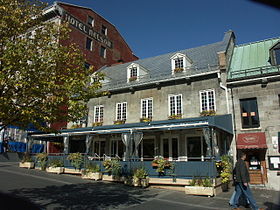
The Sir George-Étienne Cartier National Historic Site is a historic house museum located in the Old Montreal district, of Montreal, Quebec, Canada. It commemorates the life and accomplishments of Sir George-Étienne Cartier. This reconstitution of the adjoining homes of the Cartier family features the architectural heritage left by the upper middle class of 19th-century Montreal, along with interpretive activities and theatrical performances.

Réserve faunique des Laurentides, also known by its former name of parc des Laurentides, is a wildlife reserve in Quebec, Canada, located between Quebec City and the Saguenay–Lac-Saint-Jean region. This reserve is part of the network of wildlife reserves of Quebec (Canada) managed by the Ministry of Energy and Natural Resources (Quebec) and the Société des établissements de plein air du Québec. It is located halfway between Saguenay and Quebec.