Related Research Articles
Manhattan Regional Airport in Riley County, Kansas, United States, is the second-busiest commercial airport in Kansas. It is owned by the city of Manhattan, Kansas, and is about five miles southwest of downtown Manhattan. American Airlines serves the airport with five daily flights to Chicago O'Hare International Airport and Dallas/Fort Worth International Airport. The airport is also used for general aviation and for planes chartered by the military and college sports teams.

Dodge City Regional Airport is three miles east of Dodge City, in Ford County, Kansas. It is used for general aviation and is subsidized by the Essential Air Service program.
Garden City Regional Airport is nine miles southeast of Garden City, in Finney County, Kansas, United States. It sees one scheduled airline, subsidized by the federal government's Essential Air Service program at a cost of $2,919,026.
Great Bend Municipal Airport is five miles west of Great Bend, in Barton County, Kansas. It is used for general aviation and formerly saw one airline, subsidized by the Essential Air Service program.
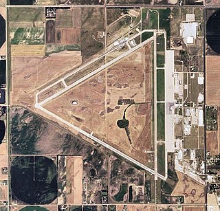
Hays Regional Airport is three miles southeast of Hays, in Ellis County, Kansas, United States. It is used for general aviation and sees one airline, United Express.

Liberal Mid-America Regional Airport is two miles west of Liberal, in Seward County, Kansas. It is used for general aviation and is subsidized by the Essential Air Service program. Formerly Liberal Municipal Airport, it hosts the Mid-America Air Museum.

Salina Regional Airport, formerly Salina Municipal Airport, is three miles southwest of Salina, Kansas, United States. The airport is owned by the Salina Airport Authority. It is used for general aviation, with service by one passenger airline, SkyWest Airlines, subsidized by the Essential Air Service program.
Cessna Aircraft Field is a public use airport located four nautical miles southeast of the central business district of Wichita, in Sedgwick County, Kansas, United States. It is privately owned by the Cessna Aircraft Company.
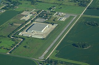
Newton City-County Airport is three miles east of Newton, in Harvey County, Kansas. It is owned by the City of Newton and Harvey County.
Hamilton Field was formerly a public-use airport located two nautical miles east of the central business district of Derby, a city in Sedgwick County, Kansas, United States. The land the airport sat on has since been subdivided for residential use, and is no longer in operation. While it was active, Hamilton Field was privately owned by Hamilton Land Group LLC.

Tillamook Airport is a public use airport located 3 miles (4.8 km) south of the central business district of Tillamook, a city in Tillamook County, Oregon, United States. It is owned by the Port of Tillamook Bay. According to the FAA's National Plan of Integrated Airport Systems for 2009–2013, it is categorized as a general aviation facility.
Saratoga County Airport is a county-owned, public-use airport located three nautical miles (6 km) southwest of the central business district of Saratoga Springs, a city in Saratoga County, New York, United States. It is included in the National Plan of Integrated Airport Systems for 2011–2015, which categorized it as a general aviation facility.
Allen County Airport is a county-owned public-use airport located three nautical miles (6 km) southeast of the central business district of Iola, in Allen County, Kansas, United States.
Hutchinson County Airport is a county-owned, public-use airport two miles north of Borger, Texas. The FAA's National Plan of Integrated Airport Systems for 2011–2015 categorized it as a general aviation facility.
Ames Field is a private use airport in Levy County, Florida, United States. It is located three nautical miles (6 km) southwest of the central business district of Trenton, a city in Gilchrist County. It is owned by Bill J. Haynes. It used to be a public use airport owned by Alicia Ames Steele.
Eureka Municipal Airport, also known as Lt. William M. Milliken Airport, is a city-owned, public-use airport located two nautical miles (4 km) north of the central business district of Eureka, a city in Greenwood County, Kansas, United States. It is included in the National Plan of Integrated Airport Systems for 2011–2015, which categorized it as a general aviation facility.
Stanton County Municipal Airport is a county-owned, public-use airport in Stanton County, Kansas, United States. It is located two nautical miles (4 km) northeast of the central business district of Johnson, Kansas, which is also known as Johnson City. This airport was included in the National Plan of Integrated Airport Systems for 2011–2015, which categorized it as a general aviation facility.
Cottonwood Falls Airport is a city-owned, public-use airport located one nautical mile (2 km) south of the central business district of Cottonwood Falls, a city in Chase County, Kansas, United States. It was formerly known as Chase County Airport.
Marion Municipal Airport is a city-owned, public-use airport located two nautical miles (4 km) southeast of the central business district of Marion, a city in Marion County, Kansas, United States.
Osage City Municipal Airport is a city-owned public-use airport located one nautical mile east of the central business district of Osage City, a city in Osage County, Kansas, United States.
References
- 1 2 3 4 "70K - Maize Airport - FAA information effective 25 September 2008". FAA data republished by AirNav. Archived from the original on October 24, 2008.