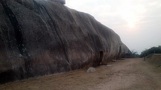
Jehanabad is a town in Nagar Parishad and is the headquarters of Jehanabad district in the Indian state of Bihar. Jehanabad is famous for Barabar Hill Caves these are the oldest surviving rock-cut caves in India, dating from the Maurya Empire some with Ashokan inscriptions.
Rajgir, meaning "The City of Kings," is a historic town in the district of Nalanda in Bihar, India. As the ancient seat and capital of the Haryanka dynasty, the Pradyota dynasty, the Brihadratha dynasty and the Mauryan Empire, as well as the dwelling ground of such historical figures as The Buddha and The Mahavira, the city holds a place of prominence in Hindu, Buddhist and Jain scriptures. As of 2011, the population of the town was reported to be 71,459 while the population in the community development block was about 88,500.

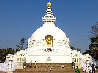
Gaya is a city, municipal corporation and the administrative headquarters of Gaya district and Magadh division of the Indian state of Bihar. Gaya is 116 kilometres (72 mi) south of Patna and is the state's second-largest city, with a population of 470,839. The city is surrounded on three sides by small, rocky hills, with the Phalgu River on its eastern side.

Patna district is one of the thirty-eight districts of Bihar state in eastern India. Patna, the capital of Bihar, is the district headquarters. The Patna district is a part of Patna division. The Patna district is divided into 6 Sub-divisions (Tehsils) i.e. Patna Sadar, Patna City, Barh, Masaurhi, Danapur and Paliganj.

Nawada district is one of the thirty-eight districts of the Indian state of Bihar. Nawada is its administrative headquarters. The district is the easternmost district of the Magadh division, one of the nine administrative divisions of Bihar. The area of the modern district was historically part of the Magadha, Shunga and Gupta empires. Koderma and Giridih districts of the state of Jharkhand lie on the southern border of the district; it also shares borders with the Gaya, Nalanda, Sheikhpura, and Jamui districts of Bihar.
Jehanabad district is one of the thirty-eight districts of Bihar state, India. Jehanabad town is the administrative headquarters of this district. Jehanabad district is a part of Magadh Division, and is located on the confluence of two small rivers called Dardha and Yamunaiya.

Gaya district is one of the thirty-eight districts of the Indian state of Bihar. It was officially established on 3 October 1865. The district has a common boundary with the state of Jharkhand to the south. Gaya city is both the district headquarters and the second-largest city in Bihar.
Daudnagar is a town and the subdivisional headquarter of Daudnagar Subdivision in Aurangabad district in the state of Bihar, India under the Magadh division. Until 1991, there was only one Subdivision in the Aurangabad district: Aurangabad Sadar. On 31 March 1991, one other subdivision, Daudnagar, was created. Daudnagar is a 200-year-old historical city and its living proof is Daudnagar has an old historical fort situated on the eastern bank of the Son River. National Highway NH139 which connects Jharkhand's Palamu district to Patna, passes through the town.
Masaurhi also known as Taregna is a city and a Nagar Parishad in Patna district in the Indian state of Bihar. Masaurhi is also one of the 6 Sub-division in Patna district.
Fatuha also spelled Fatwah or Fatwa, is a Satellite town in proposed Patna Metropolitan Region, in the Patna district in the Indian state of Bihar. Fatuha lies 24 km east of Patna the capital of Bihar. Fatuha is an important industrial centre known for small industries and its handloom industries. The city's name is said to come from its status as a center of textile manufacturing.
Konch is a community development block of Gaya district in Bihar, India. Konch(Konch Village/Konch Panchayat/Konch Thana-Police Station) is a typical village market area slowly taking shape of a sub-urban settlement and centre of small business. Konch has very important temple known as Koncheswar Mahadev belonging to the later Gupta period which now has been taken under the protection of Archaeological Survey of India (ASI).
Kudra, formerly known as Jahanabad, is a town and corresponding community development block in Kaimur district in the state of Bihar, India. It is the third largest town in Kaimur district. It is situated about 18 km from District Headquarter Bhabua. As of 2011, the population of Kudra was 30986. The railway station in Kudra is connected to all major railway routes.
Bihar has been a major centre of learning and home to one of the oldest universities of India dating back to the fifth century and the tradition of learning which had its origin from ancient times was lost during the medieval period when it is believed that marauding armies of the invaders destroyed these centres of learning.
Khatangi is a prominent village in Bihar, India. It is situated in Sonbhadra-Bansi-Surajpur Block in Arwal district of the State of Bihar. It is located at 96.1 km distance from Arwal and at 114 km distance from the state capital Patna. It is a very old village with a population of about 5,000 people. The literacy rate is 45.56%, comprising a female literacy rate of 27.3% and a male literacy rate of 62.98%. The people here are very friendly and hospitable. The economy of this village is agro-based and agriculture remains the main source of income.
Dobhi is a large village located in Dobhi Block of the Gaya district in the northeast Indian state of Bihar.
Kako is a town in Jehanabad district of Bihar, a state in northeastern India. Until 1984, Kako was a part of the Gaya district. In 2010, the town's state representation was shifted from the Jehanabad constituency to the Ghosi constituency of Bihar's Vidhan Sabha. Though the population density is very high, the basic infrastructure is not optimal.
Jehanabad railway station, station code JHD, is the railway station serving the city of Jehanabad in the Jehanabad district in the Indian state of Bihar. The Jehanabad railway station is well connected to Patna, Gaya, Ranchi and Bokaro by the railway network. Jehanabad lies in between Patna–Gaya line which is one of the busiest rail route in India. Jehanabad has trains running frequently to Patna and Ranchi. The city is a major railway hub and has four stations Jehanabad railway station, Jehanabad Court, Makhdumpur–Gaya and Tehta. Jehanabad is well connected with Gaya, Patna, Biharsharif, Rajgir, Islampur and Jhajha through daily passenger and express train services.
Nayadih is a village among a block of villages in Derhgaon of the Kashichak Block, Nawada District, in Bihar, India. The main villages of Nayadih, Derhgaon and Bishwanathpur together have been referred to as Derhgaon.
Mananpur is a village situated in Okari Block in Jehanabad District of Bihar State in India. It is located 6.5 km from Bandhuganj and at 4 km from Telhara. The Total population of this village is around 1500.
Dharnai is a small village located in the district of Makhdumpur, Jehanabad in the Indian state of Bihar. It is located approximate 73 km from the state capital Patna. The postal code is 804421.
