Makololo tribe

Last updated

The Makololo (Kololo) are a Tswana people of Southern Africa from Bafokeng Tswana Clan, closely related to the other Tswana People, from which they separated themselves[ clarification needed ] in the early 19th century. Originally residing in what is now North West South Africa, they were displaced by the Zulu expansion under Shaka and in 1823 started a migration north through Botswana to Barotseland. [1]

The Tswana are a Bantu-speaking ethnic group who are native to Southern Africa. The Tswana language belongs to the Bantu group. Ethnic Tswana made up approximately 85% of the population of Botswana in 2011.

Southern Africa southernmost region of the African continent

Southern Africa is the southernmost region of the African continent, variably defined by geography or geopolitics, and including several countries. The term southern Africa or Southern Africa, generally includes Angola, Botswana, Eswatini, Lesotho, Malawi, Mozambique, Namibia, South Africa, Zambia, and Zimbabwe, though Angola may be included in Central Africa and Malawi, Mozambique, Zambia and Zimbabwe in East Africa. From a political perspective the region is said to be unipolar with South Africa as a first regional power.

In what is now southern Botswana they defeated a number of societies before suffering a catastrophic defeat to the Bangwaketse at Dithubaruba in 1826. [2] After losing all their cattle they moved north east and raided again, but subsequent defeats led them north to Okavango Delta where they again suffered major losses but were able to defeat the Batawana people in 1835. This victory enabled them to replenish their population and cattle holdings, although they moved north after several years. [3]

In 1838, the Makololo leader, Sebetwane crossed the Zambezi River and, by 1845, he had conquered the Lozi people of the Barotseland kingdom and became king. He died in 1851 shortly after meeting David Livingstone, and was succeeded, first, by his daughter Mamochisane, who soon abdicated in favour of her younger half-brother Sekeletu. [4] After about 20 years the Makololo kingdom was overthrown in a revolution, although some survivors (women and children) remained, [5]

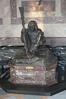
Sebetwane was a Southern African king, Tswana chief of the Bafokeng Tswana Clan. He established the large and powerful Makololo nation in what is now southwestern Zambia after an arduous migration from his original home, North West Province.

Lozi people ethnic group

The Lozi people are an ethnic group primarily of western Zambia, inhabiting the region of Barotseland. They number approximately 575,000 in Zambia out of a population of 10 million. Lozi are also found in Namibia, Angola, Botswana, Mozambique (50,000), and Zimbabwe (8,000). The Lozi are also known as the Barotsi, Malozi, Silozi, Kololo, Barotose, Rotse, Rozi, Rutse, or Tozvi. The Lozi speak Silozi, a central Bantu language. The lives of the Lozi people seem to revolve around the Zambezi river, which is the second longest river in Africa.

Barotseland

Barotseland is a region between Namibia, Botswana, Zimbabwe, Zambia and Angola. It is the homeland of the Lozi people or Barotse, or Malozi, who are a unified group of over 20 individual formerly diverse tribes related through kinship, whose original branch are the Luyi (Maluyi), and also assimilated northern Sotho tribe of South Africa known as the Makololo.

Sekeletu provided Livingstone with manu porters for his transcontinental journey from Luanda on the Atlantic to Quelimane on the Indian Ocean, made between 1854 and 1856. Around 100 of these men were left at Tete in 1856 when Livingstone made his way to Quelimane and then to Britain. [6] Livingstone returned to Africa to start his second Zambezi expedition in 1858. On reaching Tete, he was reunited with the porters he left there in 1856 and attempted to repatriate them all to Barotseland. However, by this time Sekeletu was facing increasing opposition from the Lozi majority, and around 16 of them decided to remain on the middle Zambezi. [7]

Luanda City in Angola

Luanda, formerly named São Paulo da Assunção de Loanda, is the capital and largest city in Angola, It is Angola's primary port, and its major industrial, cultural and urban centre. Located on Angola's northern coast with the Atlantic Ocean, Luanda is both Angola's chief seaport and its administrative centre. It is also the capital city of Luanda Province. Luanda and its metropolitan area is the most populous Portuguese-speaking capital city in the world, with over 8 million inhabitants in 2019, a third of Angola's population; it is the third most populous Portuguese-speaking city, after the Brazilian cities of São Paulo and Rio de Janeiro.

Quelimane Place in Zambezia Province, Mozambique

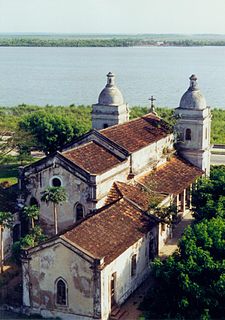
Quelimane is a seaport in Mozambique. It is the administrative capital of the Zambezia Province and the province's largest city, and stands 25 km (16 mi) from the mouth of the Rio dos Bons Sinais. The river was named when Vasco da Gama, on his way to India, reached it and saw "good signs" that he was on the right path. The town was the end point of David Livingstone's west-to-east crossing of south-central Africa in 1856. Portuguese is the official language of Mozambique, and many residents of the areas surrounding Quelimane speak Portuguese. The most common local language is Chuabo. Quelimane, along with much of Zambezia Province, is extremely prone to floods during Mozambique's rainy season. The most recent bout of severe flooding took place in January 2007.

Tete, Mozambique Place in Tete Province, Mozambique

Tete is the capital city of Tete Province in Mozambique. It is located on the Zambezi River, and is the site of two of the four bridges crossing the river in Mozambique. A Swahili trade center before the Portuguese colonial era, Tete continues to dominate the west-central part of the country and region, and is the largest city on the Zambezi. In the local language, Nyungwe, Tete means "reed."

Those Makololo remaining were used from 1859 onward, by Livingstone and by missionaries of the Universities' Mission to Central Africa (UMCA), as porters and armed guards to support their activities in the Shire valley and Shire Highlands including the freeing of slaves, and were paid in guns, ammunition and cloth. The Makololo decided to remain in the Shire valley when the missionaries left in January 1864. [8]

Universities Mission to Central Africa

The Universities' Mission to Central Africa was a missionary society established by members of the Anglican Church within the universities of Oxford, Cambridge, Durham, and Dublin. It was firmly in the Anglo-Catholic tradition of the Church, and the first to devolve authority to a bishop in the field rather than to a home committee. Founded in response to a plea by David Livingstone, the society established the mission stations that grew to be the bishoprics of Zanzibar and Nyasaland, and pioneered the training of black African priests.

The Shire Highlands are a plateau in southern Malawi, located east of the Shire River. Ranging in elevation from 2,000 feet (610 m) to 4,000 feet (1,200 m), it is a major agricultural area and the most densely populated part of the country.

After the 1864 departure of the UMCA mission, which left behind supplies of arms and ammunition, the Makololo maintained themselves by hunting elephants for ivory and attracted dependents seeking protection, many of whom were freed slaves. They and their armed dependents established chieftaincies in the present-day Chikwawa District. Originally, ten Makololo became chiefs or headmen and five Makololo chiefs still exist today. [9]

Chikwawa is a district in the Southern Region of Malawi. The capital is Chikwawa. The district covers an area of 4,755 km.² and has a population of 356,682.

The Makololo chiefs recognised by the governments of colonial Nyasaland and independent Malawi have their origin in a group of porters that David Livingstone brought from Barotseland in the 1850s to support his first Zambezi expedition that did not return to Barotseland but assisted Livingstone and British missionaries in the area of southern Malawi between 1859 and 1864. After the withdrawal of the Universities' Mission to Central Africa those Makololo remaining in the Shire valley used firearms provided by the Europeans to attract dependants seeking protection, to seize land and to establish a number of chieftainships. At the time that a British protectorate was established in 1891, there were seven Makololo chiefs of which six were recognised by the government. Five survived to be given local governmental powers in 1933, and these powers continued after Malawi became independent. Although called Makololo or Kololo, after the ruling group in Barotseland in the 1850s, the majority came from peoples subject to the Makololo who adopted the more prestigious name. As, regardless of their origin, they took wives from among the inhabitants of the Shire valley, their modern descendants have little connection with Makololo people of southern Africa except their name.

They appear to be named after Kololo, the wife of their first chief, Sebitwane. Another theory is that it is a Luyana word meaning "bald" referring to their conqueror's hairstyles.

Related Research Articles

Zambezi fourth-longest river in Africa

The Zambezi is the fourth-longest river in Africa, the longest east-flowing river in Africa and the largest flowing into the Indian Ocean from Africa. The area of its basin is 1,390,000 square kilometres (540,000 sq mi), slightly less than half of the Nile's. The 2,574-kilometre-long river (1,599 mi) rises in Zambia and flows through eastern Angola, along the north-eastern border of Namibia and the northern border of Botswana, then along the border between Zambia and Zimbabwe to Mozambique, where it crosses the country to empty into the Indian Ocean.

British Central Africa Protectorate

The British Central Africa Protectorate (BCA) was a protectorate proclaimed in 1889 and ratified in 1891 that occupied the same area as present-day Malawi: it was renamed Nyasaland in 1907. British interest in the area arose from visits made by David Livingstone from 1858 onward during his exploration of the Zambezi area. This encouraged missionary activity starting in the 1860s, undertaken by the Universities' Mission to Central Africa, the Church of Scotland and the Free Church of Scotland followed by a small number of settlers. The Portuguese government attempted to claim much of this area, but their claims were disputed by the British government. To forestall a Portuguese expedition claiming effective occupation, a protectorate was proclaimed, first over the south of this area, then over the whole of it in 1889. After negotiations with the Portuguese and German governments on its boundaries, the protectorate was formally ratified by the British government in May 1891.

Mfecane

Mfecane, also known by the Sesotho name Difaqane or Lifaqane, was a period of widespread chaos and warfare among indigenous ethnic communities in southern Africa during the period between 1815 and about 1840.

Lozi, also known as siLozi and Rozi, is a Bantu language of the Niger–Congo language family within the Sotho–Tswana branch of Zone S (S.30), that is spoken by the Lozi people, primarily in southwestern Zambia and in surrounding countries. This language is most closely related to Northern Sotho, Tswana (Setswana), Kgalagari (SheKgalagari) and Sotho. Lozi and its dialects are spoken and understood by approximately six percent of the population of Zambia. Silozi is the endonym as defined by the United Nations. Lozi is the exonym.

Okavango Delta river delta

The Okavango Delta in Botswana is a swampy inland delta formed where the Okavango River reaches a tectonic trough in the central part of the endorheic basin of the Kalahari. All the water reaching the delta is ultimately evaporated and transpired and does not flow into any sea or ocean. Each year, about 11 cubic kilometres (2.6 cu mi) of water spread over the 6,000–15,000 km2 (2,300–5,800 sq mi) area. Some flood waters drain into Lake Ngami. The area was once part of Lake Makgadikgadi, an ancient lake that had mostly dried up by the early Holocene.

Livingstone, Zambia Place in Southern Province, Zambia

Livingstone is a city in Southern Province of Zambia. Until 2012, it served as the province's capital. Lying 10 km (6.2 mi) to the north of the Zambezi River, it is a tourism centre for the Victoria Falls and a border town with road and rail connections to Zimbabwe on the other side of the Victoria Falls. A historic British colonial city, its present population was estimated at 136,897 inhabitants at the 2010 census. It is named after David Livingstone, the British explorer and missionary who was the first European to explore the area.

1890 British Ultimatum

The 1890 British Ultimatum was an ultimatum by the British government delivered on 11 January 1890 to Portugal. The ultimatum forced the retreat of Portuguese military forces from areas which had been claimed by Portugal on the basis of historical discovery and recent exploration, but which the United Kingdom claimed on the basis of effective occupation. Portugal had attempted to claim a large area of land between its colonies of Mozambique and Angola including most of present-day Zimbabwe and Zambia and a large part of Malawi, which had been included in Portugal's "Rose-coloured Map".

Pink Map Portuguese diplomatic document

The Pink Map, more generally known in English-language known as the Rose-Coloured Map, was a document prepared in 1885 to represent Portugal's claim of sovereignty over a land corridor connecting their colonies of Angola and Mozambique during the "Scramble for Africa". The area claimed included almost all of what is currently Zimbabwe and large parts of modern Zambia and Malawi. In the first half of the 19th century, Portugal fully controlled only a few coastal towns in Angola and Mozambique. It also claimed suzerainty over other almost independent towns and nominally Portuguese subjects in the Zambezi valley, but could rarely enforce its claims; most of the territory now within Angola and Mozambique was entirely independent of any Portuguese control. Between 1840 and 1869, Portugal expanded the area it controlled but began to feel threatened by the activities of other powers.

George Fleming was an African-American explorer and trader. A former slave, he accompanied David Livingstone in exploring northern Botswana and central Africa.

Sipopa Lutangu King of the Lozi people

Sipopa Lutangu was the leader of the Lozi revolution and later a Litunga (king) of the Lozi people. He ruled 1864–1876.

Eugene Charles Albert Sharrer was a British subject by naturalisation but of German descent, who was a leading entrepreneur in what is now Malawi for around fifteen years between his arrival in 1888 and his departure. He rapidly built-up commercial operations including wholesale and retail trading, considerable holdings of land, cotton and coffee plantations and a fleet of steamers on the Zambezi and Shire rivers. Sharrer was prominent in pressure groups that represented the interests of European planters and their businesses to the colonial authorities, and was responsible for the development of the first railway in what had become the British Central Africa Protectorate, whose construction was agreed in 1902. In 1902, Sharrer consolidate all his business interests into the British Central Africa Company Ltd and became its principal shareholder Shortly after this he left British Central Africa permanently for London, although he retained his financial interests in the territory. Very little is known of his history before he arrived in Central Africa but he died in London during the First World War.

The Anglo-Portuguese Treaty of 1891 was an agreement between the United Kingdom of Great Britain and Ireland and Portugal which fixed the boundaries between the British Central Africa Protectorate, and the territories administered by the British South Africa Company in Mashonaland and Matabeleland and North-Western Rhodesia and Portuguese Mozambique, and also between the British South Africa Company administered territories of North-Eastern Rhodesia, and Portuguese Angola.

John Buchanan (1855–1896), was a Scottish horticulturist who went to Central Africa, now Malawi, in 1876 as a lay member of the missionary party that established Blantyre Mission. Buchanan came to Central Africa as an ambitious artisan: his character was described as dour, devout and as restlessly ambitious, and he saw in Central Africa a gateway to personal achievement. He started a mission farm on the site of Zomba, Malawi but was dismissed from the mission in 1881 for brutality. From being a disgraced missionary, Buchanan first became a very influential planter owning, with his brothers, extensive estates in Zomba District. He then achieved the highest position he could in the British administration as Acting British Consul to Central Africa from 1887 to 1891. In that capacity declared a protectorate over the Shire Highlands in 1889 to pre-empt a Portuguese expedition that intended to claim sovereignty over that region. In 1891, the Shire Highlands became part of the British Central Africa Protectorate. John Buchanan died at Chinde in Mozambique in March 1896 on his way to visit Scotland, and his estates were later acquired by the Blantyre and East Africa Ltd.

The M'Bona Cult is a system of religious beliefs and rituals currently limited to the most southerly parts of Malawi, but probably more extensive formerly, and found among the local Mang'anja people. It aims to secure abundant rains at the appropriate season through the making of propitiatory gifts at cult shrines, and includes rainmaking rituals in the event of drought. It has been related to a number of other territorial cults among the Maravi cluster of related African peoples, which aim to secure the well-being of the people of a particular area secure from drought, floods or food shortages. The cult is believed to be a long established one, although estimates of how long it has existed are speculative, as the earliest definite record of its existence dates from 1862.

The M10 Road is a Road in Zambia. It goes from Livingstone, through Sesheke, to Mongu. The Road is approximately 508 kilometres and follows the Zambezi River for its entire length.

References

  1. Phiri, Bizeck J. (2005). "Lozi Kingdom and the Kololo". In Shillington, Kevin (ed.). Encyclopedia of African History, Volume II, H-O. New York: Fitzroy Dearborn (Routledge). pp.  851–852. ISBN   978-1-57958-454-2.
  2. J. Ramsay, B. Morton, and T. Mgadla, Building a Nation: A History of Botswana from 1800 to 1910. Gaborone: Longmans, 1996, 66-8.
  3. Moanaphuti Segolodi, "Ditso Tsa Batawana," 1940. https://www.academia.edu/12170767/Ditso_Tsa_Batawana_by_Moanaphuti_Segolodi_1940
  4. N. R. Bennett, (1970). David Livingstone: Exploration for Christianity in R. I. Rotberg (editor), Africa and its Explorers. Harvard University Press, p.42.
  5. Gann, Lewis H.; Duignan, Peter (1999). Africa and the world: An introduction to the history of sub-Saharan Africa from antiquity to 1840. Lanham, Maryland: University Press of America. p.  413–414. ISBN   0-7618-1520-1.
  6. T. Jeal, (2013). Livingstone: Revised and Expanded Edition, Yale University Press, pp. 93, 103–105.
  7. J. McCracken, (2012). A History of Malawi, 1859–1966, Woodbridge, James Currey, pp. 39-41.
  8. L. White, (1987). Magomero: Portrait of an African Village, Cambridge University Press, pp. 17, 39, 64-7.
  9. J. McCracken, (2012). A History of Malawi, 1859–1966, Woodbridge, James Currey, pp. 41-2.