
The Los Ríos Region is one of Chile's 16 regions, the country's first-order administrative divisions. Its capital is Valdivia. It began to operate as a region on October 2, 2007, having been created by subdividing the Los Lagos Region in southern Chile. It consists of two provinces: Valdivia and the newly created Ranco Province, which was formerly part of Valdivia Province.

Valdivia Province is one of two provinces of the southern Chilean region of Los Ríos (XIV). The provincial capital is Valdivia. Located in the province are two important rivers, the Calle-Calle / Valdivia River and the Cruces River.It is part of Northern Patagonia and its wild virgin forest embrace the Patagonian Cordillera following the river Calle Calle down to the Pacific Ocean. It is known in Patagonia the term "Bosque Valdiviano" referring to the primitive forest of Valdivia with its native trees. These forests are present in some parts of Northern Patagonia, both in Chile and Argentina.
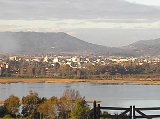
Panguipulli is a city and commune in Valdivia Province, southern Chile, administered by the Municipality of Panguipulli. The town is known for its natural environment, and is called "City of roses". Panguipulli is located on the western edge of Panguipulli Lake, and is on a moraine in the Chilean Central Valley. Most of the commune lies on Andean mountains and valleys.
The Cruces River is a river near Valdivia, Chile. Río Cruces originates from hills near the Villarica volcano and flows then in south-west direction. The southern and final part of the river follows the Valdivian Coastal Range. At the latitude of Valdivia it is crossed by Río Cruces Bridge near its outflow into Valdivia River. The small village of Punucapa is the main centre for tourism in Río Cruces. The river flow through the cities of Loncoche, Lanco, and Mariquina. Some of the wetlands in the river's lower flow are inside Carlos Anwandter Nature Sanctuary, a protected area that in the river that extends roughly from Punucapa in the south to San Luis de Alba Fort in the north.

Huilo-Huilo Biological Reserve is a private for profit natural reserve and ecotourism project in southern Chile. The reserve was created in 1999 and includes 600 km2 (232 sq mi) of native forest in Chile dedicated to wildlife conservation and tourism. The reserve is owned by the businessman Víctor Petermann who bought it in the 1990s, and was prior to the land sellings of the late Pinochet dictatorship part of Complejo Forestal y Maderero Panguipulli. The reserve has a number of unique hotels, including Montana Mágica, the Nothofagus hotel, cabins, and a lodge for backpackers. The grounds also include a brewery, various animal habitats, a funicular, and many miles of trails. The reserve includes many waterfalls and the eastern slopes of Mocho-Choshuenco, a glacial compound stratovolcano. The nearest town to Huilo-Huilo is Neltume, the site of a 1981 violent episode between members of MIR, and members of the military dictatorship in Chile.

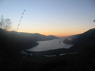
The Panguipulli Lake is one of the "Seven Lakes" in Panguipulli municipality, southern Chile. The lake is of glacial origin and it is enclosed by mountain ranges of the Andes, on all sides except the west, where the town of Panguipulli lies in the Chilean Central Valley. The lake is drained by the Enco River that flows south to Riñihue Lake.
Enco River is a river in Panguipulli commune in southern Chile. By flowing from Panguipulli Lake to Riñihue Lake Enco River carries the water of the six upper lakes of the Seven Lakes area into Riñihue, the last lake in the chain. Located between the piedmont of Mocho-Choshuenco Volcano and Cerro Maltusado Enco River is unusual because it drains Panguipulli Lake through its eastern and mountainous end rather than allowing the lake to drain through the low moraine hills in the west.
Neltume is a Chilean town in Panguipulli commune, of Los Ríos Region. It lies along the 203-CH route to Huahum Pass into Argentina. The town's main economic activities are forestry and, more recently, tourism since the Huilo-Huilo Biological Reserve was created in 1999. During large periods of the 20th century Neltume was a site of social mobilizations and unrest, events which culminated in 1981 with the crack down of the "Toqui Lautaro" guerrilla set of by MIR to fight the military dictatorship in Chile.

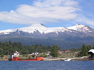
Coñaripe is a Chilean town and resort area, located on the shore of Calafquén Lake. Administratively it belongs to Panguipulli commune in Valdivia Province of Los Ríos Region.
Fuy River is a river in the commune of Panguipulli, southern Chile. It drains Pirihueico Lake and flows southward along the village of Neltume where it joins Neltume River and creates together Panguipulli Lake. The river's origin is near the village of Puerto Fuy (es).
Choshuenco is a village on the eastern edge of Panguipulli Lake in Panguipulli commune, Los Lagos Region, Chile. It is 4 kilometres (2.5 mi) south of the 203-CH route that goes from Lanco to Huahum Pass. It is 33 kilometres (21 mi) west of the Argentina border.

The Avro 533 Manchester was a First World War-era twin-engine biplane photo-reconnaissance and bomber aircraft designed and manufactured by Avro.
International Route 203-CH is a branch line road going eastward from Lanco at Chile Highway 5 to Huahum Pass at the border to Argentina. Some settlements along the road includes: Lanco, Malalhue, Panguipulli and Neltume. The road is paved from Laco to the north side of Panguipulli Lake where it becomes a gravel road.
Puerto Fuy is a Chilean village in Panguipulli commune, of Los Ríos Region. Puerto Fuy lies along the 203-CH route to Huahum Pass into Argentina at western edge of Pirihueico Lake and is a terminal station of the ferry that crosses the lake connecting to Puerto Pirihueico.
Llancahue River is a river in Panguipulli commune, southern Chile. It drains Pellaifa Lake and flows westward into Calafquén Lake of which it is the primary source.
Calafquén is a Chilean hamlet in Panguipulli commune, of Los Ríos Region. Located on the southern shores of Calafquén Lake, Calafquén is a popular resort area during the summer months (December–February).
The Reigolil-Pirihueico Fault is a second-order geological fault located in the Chilean and Argentine Andes. As the name implies it runs from Pirihueico Lake to Reigolil Valley. Reigolil-Pirihueico Fault run in north-south direction and is roughly parallel to the larger Liquiñe-Ofqui Fault which is located 15 to 20 km west of it to which it is considered a branch of. East of Reigolil-Pirihueico Fault, close or along the Argentina-Chile boundary, are a string of volcanoes pliocene to quaternary volcanoes; Lanín, Pirihueico, Huanquihué, Quelguenco and Chihuío.
Panguipulli Formation is a sedimentary formation of Triassic age located in Los Ríos Region and southernmost Araucanía Region in south–central Chile. The formation is variously covered by Quaternary lavas in the east and Quaternary morraines, Holocene alluvium and colluvium in the west. The formation and make up possibly the remnants of an ancient lake and river system. The formation is named after the town of Panguipulli on the western edge of Panguipulli Lake. The formation has evidence of low grade metamorphism and is locally intruded by plutons of the North Patagonian Batholith that are of Jurassic, Cretaceous and Miocene age.

Troltrolhue or Cordillera Troltrolhue is a mountain and mountain range in Los Ríos Region, southern Chile. The mountain range runs from west to east across five communes; Mariquina, Lanco, Máfil, Los Lagos and Panguipulli. It lies south and east of Cruces River and west of Calafquén and Panguipulli lakes. Part of the southeastern slope of the mountain range is a fault scarp. There are historical placer-type gold mines in the Troltrolhue.


