Crete is the largest and most populous of the Greek islands, the 88th largest island in the world and the fifth largest island in the Mediterranean Sea, after Sicily, Sardinia, Cyprus, and Corsica. Crete rests about 160 km (99 mi) south of the Greek mainland, and about 100 km (62 mi) southwest of Anatolia. Crete has an area of 8,450 km2 (3,260 sq mi) and a coastline of 1,046 km (650 mi). It bounds the southern border of the Aegean Sea, with the Sea of Crete to the north and the Libyan Sea to the south. Crete covers 260 km from west to east but is narrow from north to south, spanning three longitudes but only half a latitude.
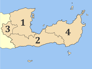
Lasithi is the easternmost regional unit on the island of Crete, to the east of Heraklion. Its capital is Agios Nikolaos, the other major towns being Ierapetra and Sitia. The mountains include the Dikti in the west and the Thrypti in the east. The Sea of Crete lies to the north and the Libyan Sea to the south.

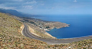
Myrtos is a coastal village and a community in the west of the municipality of Ierapetra, in the Regional Unit of Lasithi on the Greek island of Crete. It is located 50 km (31 mi) from Agios Nikolaos and 15 km (9.3 mi) from Ierapetra, on the road to Viannos. A little to the west of the village is the iconic conical Kolektos mountain. Myrtos is situated on the Libyan Sea. The patron saint of the village is Saint Anthony. The population of the community is 518 (2021).

Hersonissos, also transliterated as Chersonissos and Hersónisos, is a town and a local government unit in the north of Crete, bordering the Mediterranean / Aegean Sea. The town is about 25 kilometers east of Heraklion and west of Agios Nikolaos. What is usually called Hersonissos is in fact its peninsula and harbour. It is part of the Heraklion regional unit. It is situated 25 km from the Heraklion airport and 27 km from the Heraklion port. The seat of the local government unit is the village of Gournes.

Sitia or Siteia is a port town and a municipality in Lasithi, Crete, Greece. The town has 11,166 inhabitants and the municipality has 20,438 (2021). It lies east of Agios Nikolaos and northeast of Ierapetra. Sitia's port is on the Sea of Crete, part of the Aegean Sea and is one of the economic centers of the Lasithi region. European route E75, which ends in Vardø, starts in Sitia. Sitia is served by the Sitia Public Airport. Sitia has not experienced the effects of mass tourism even though there is a long beach along the road leading to Vai and several places of historical interest.
Sfakiá is a mountainous area in the southwestern part of the island of Crete, in the Chania regional unit. It is considered to be one of the few places in Greece that have never been fully occupied by foreign powers. With a 2021 census population of 2,002 inhabitants living on a land area of 467.589 km2 (180.537 sq mi), Sfakia is one of the largest and least densely populated municipalities on the island of Crete. The etymology of its name is disputed. According to the prevailing theory, it relates to its rugged terrain, deriving from the ancient Greek word σφαξ, meaning land chasm or gorge.

Ierapetra is a Greek city and municipality located on the southeast coast of Crete.

Makry Gialos is a former municipality in Lasithi, Crete, Greece, with a population 2,589 in 2021. It is located on the south-east coast of Crete. Since the 2011 local government reform it is part of the municipality Ierapetra, of which it is a municipal unit. The municipal unit has an area of 75.376 km2 (29.103 sq mi). The seat of the municipality was in Koutsouras, 22 kilometers east of Ierapetra. It was established in 1997 when the communities of Stavrochori, Chrysopigi, Lithines, Schinokapsala, Agios Stefanos, Oreino, Perivolakia and Pefkoi amalgamated into one municipality (Δήμος). In November 2011 the four communities Chrysopigi, Lithines, Perivolakia and Pefkoi passed to the municipality Siteia.

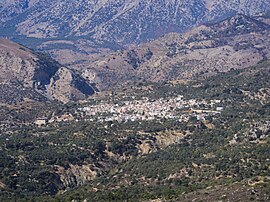
Anatoli is a village in the Ierapetra municipality of the prefecture of Lasithi in eastern Crete. It is built 600 meters above sea level and the view over Ierapetra to the sea with Chrysi island opposite, is unique. It is called the "Libyan sea balcony". Despite the destruction of the surrounding wooded area, due to fire in recent years, the whole landscape is fantastic.
Schinokapsala is a community and a small village in Lasithi on Crete. It is situated 21 kilometers north-east from Ierapetra and 6 km from the sea. Since 2011 it belongs to the Ierapetra municipality.

Oreino is a small village in Lasithi regional unit on Crete, Greece. It is situated 28 kilometers northeast of Ierapetra and lies 10 kilometers from the Cretan south coast. Since 2011, it is part of the Ierapetra municipality. It is situated at 650 meters above sea level, east of the Thrypti mountains, in an area rich in vegetation. A gorge with the same name is also part of the village and contained a neo-Byzantine church with frescos.

Agios Ioannis is a village of Lasithi prefecture, in the municipality of Ierapetra, Crete, Greece. It lies 17 kilometers north-east of Ierapetra, 7 kilometers west of Schinokapsala, and 9 kilometers from the sea. It is south of Thripti mountain. The majority of the people that lived here have moved during the last three decades to the beach settlements of Koutsounari and Ferma, or to Ierapetra. The water from the springs follows a route across "Milonas gorge" and ends in the sea some 7 kilometers further. In the Aghios Ioannis area there are also a number of beaches, including the Long beach and Aghia Fotia.

Gdochia is a village on Crete 20 kilometers west of Ierapetra built in an area with views of Ierapetra town and the sea. It is said to receive his name from an ancient word that means "it has rain". In September 1943, over 40 residents of Gdochia were brutally executed by the Nazis.
Kato Symi is a small historic village of Crete, in Heraklion regional unit, 31 km (19 mi) from Ierapetra and 74 km (46 mi) from Heraklion city. Today it belongs to Viannos municipality and borders the Ierapetra municipality. It lies about 780 m (2,560 ft) above sea level, south of Mount Dikti in a verdant mountainous area, which is probably the most wooded of Crete. Near the village, at an altitude of 1,200 m (3,900 ft), lies the ancient sanctuary of Hermes and Aphrodite. It is dated from the middle Minoan period and had been used for worship for more than 1,000 years. Kato Simi has been destroyed three times, by Arabs, Turks and finally by the German army in World War II, when it was the center of resistance of the Viannos–Ierapetra area against the Nazi occupying forces.
Stavrochori is an historic village of eastern Crete. It belonged to the former province of Sitia and later to the former Makry Gialos municipality. Today it is part of Ierapetra municipality. It is located in a wooded valley, 29 kilometers north east from Ierapetra and 35 kilometers southwest from Sitia. Once it was the most populous village of the region and the administrative center of the surrounding settlements. Since the last 30 years, the majority of its population has moved to the seaside settlement of Koutsouras, 7 kilometers to the south. Stavrochori is a traditional village with many sights. It is also the birthplace of Ioannis Papachatzakis or "Stravogiannios", a violinist, who lived and died in Ierapetra. He was one of the most important Cretan traditional organ players of the last century.
Agios Stefanos is a village within the Lasithi prefecture in eastern Crete. It belonged to the former province of Siteia until that was abolished in 2006. Between 1997 and 2010, it was part of the former Makry Gialos municipality. Today, it is part of Ierapetra municipality. It is located 30 kilometers north-east of Ierapetra, 40 kilometers southwest of Sitia, and six kilometers east of Stavrohori. It can be approached through the famous forest of Pefkoseli. Its patron is Saint Stephen. Saint Stephen church, at the entrance of the village, is an ecclesiastical and historical monument of Crete. Since the last decade, the majority of the population has been moved to the village's seaside settlement of Makry Gialos, some six kilometers to the south. Makry Gialos is one of Crete's most important tourist resorts.

Rethymno is a city in Greece on the island of Crete. It is the capital of Rethymno regional unit, and has a population of more than 34,000 inhabitants.
Maroulas is a local community of the Rethymno Municipality in the Rethymno of the region of Crete established by Kallikratis reform. It is traditional settlement and is classified in Class II, that is of average cultural value.
Roussospiti is a local community of the Rethymno Municipality in the Rethymno of the region of Crete established by Kallikratis reform. Previously, it was part of the former municipality of Rethymno. It is a traditional settlement and is classified in Class II, that is of average cultural value.
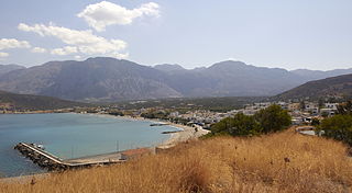
Pacheia Ammos is a village in the municipality of Ierapetra on the island of Crete in Greece. It is located on the north coast of the island, 15 km to the north of the city of Ierapetra, at the fork in the road that leads to Heraklion in the west and Sitia in the east.