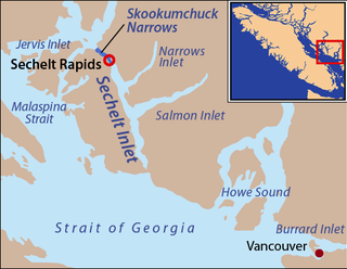
Skookumchuck Narrows is a strait forming the entrance of Sechelt Inlet on British Columbia's Sunshine Coast in Canada. Before broadening into Sechelt Inlet, all of its tidal flow together with that of Salmon Inlet and Narrows Inlet must pass through Sechelt Rapids. At peak flows, standing waves, whitecaps, and whirlpools form at the rapids even in calm weather. The narrows are also the site of Skookumchuck Narrows Provincial Park.

Jervis Inlet is one of the principal inlets of the British Columbia Coast, about 95 km (59 mi) northwest of Vancouver, and the third of such inlets north of the 49th parallel, the first of which is Burrard Inlet, Vancouver's harbour.
Princess Louisa Marine Provincial Park is a provincial park in British Columbia, Canada surrounding Princess Louisa Inlet.

Princess Louisa Inlet is a fjord on British Columbia’s Sunshine Coast and within the swiya of the shíshálh Nation.

Mount Alfred is a mountain located at the Queen Reach arm and head of the Jervis Inlet within the Pacific Ranges of the Coast Mountains in British Columbia, Canada. The mountain is the highest in the portion of the mainland between Jervis and Toba Inlets, with its 1,318 metres (4,324 ft) prominence defined by the pass at the head of the Skwawka River, which feeds the head of Jervis Inlet. The unofficially-named Alfred Creek Falls, on Alfred Creek which drains off the mountain's glaciers southeast into the Skwawka, is one of Canada's highest waterfalls at 700 metres (2,297 ft).

Mount Frederick William is a mountain located at the Queen Reach arm of the Jervis Inlet within the Pacific Ranges of the Coast Mountains in British Columbia Canada. The mountain was named during the 1860 survey by HMS Plumper which charted all of the area and named the mountain after then-Prussian Crown Prince Frederick William, who had married Princess Victoria, the eldest child of Queen Victoria and Prince Albert.

Mount Arthur is a mountain located at the Queen Reach arm of the Jervis Inlet within the Pacific Ranges of the Coast Mountains in British Columbia Canada. The mountain was named during the 1860 survey by HMS Plumper who charted all of the area and named the mountain after Prince Arthur William Patrick who was the seventh son of Queen Victoria and Prince Albert of England.
Mount Wellington is a mountain located at the Queens Reach arm of the Jervis Inlet within the Pacific Ranges of the Coast Mountains in British Columbia Canada. The mountain was named during the 1860 survey by HMS Plumper who charted all of the area and named the mountain after Duke of Wellington who defeated Napoleon at the famous battle of Waterloo.
Mount Alice is a mountain located at the Queens Reach arm of the Jervis Inlet within the Pacific Ranges of the Coast Mountains in British Columbia Canada. The mountain was named during the 1860 survey by HMS Plumper who charted all of the known area and named the mountain after Alice Maud Mary who was the third child of Queen Victoria and Prince Albert.
Mount Helena is a mountain located at the Queen Reach arm of Jervis Inlet and behind Princess Louisa Inlet. Mount Helena is part of the Pacific Ranges of the Coast Mountains in British Columbia Canada. The mountain was named during the 1860 survey by HMS Plumper who charted all of the known area and named the mountain after Princess Helena Augusta Victoria "Lenchen" who was the fifth child of Queen Victoria and Prince Albert of England.
One Eye Peak is a mountain located at Princess Louisa Inlet. One Eye Peak is part of the Pacific Ranges of the Coast Mountains in southwestern British Columbia, Canada. When Thomas F. Hamilton build his resort called the Malibu Club at the entrance of Princess Louisa Inlet he named the mountain after himself - Mt. Hamilton. The mountain is typically referred to by its English title of a Sechelt First Nation translation "TUHK-OHSS" referring to "Old One Eye" and is the protector of the inlet.
ḵ’els is a mountain located at the head of lekw’emin above the ancestral shíshálh village site of x̱enichen and within the Pacific Ranges of the Coast Mountains of British Columbia, Canada. The mountain is associated with a shíshálh legend about a great flood.
Queens Reach is the last arm of the Jervis Inlet and is located within the Coast Mountain Range of British Columbia, Canada. This arm was named during the 1860 survey by HMS Plumper which charted all of the area and was named after Queen Victoria of the United Kingdom.
Prince of Wales Reach is the first arm of the Jervis Inlet and is located within the Coast Mountain Range of British Columbia, Canada. This arm was named during the 1860 survey by HMS Plumper who charted all of the area and was named after Albert Edward - the Prince Of Wales, later Edward VII, who was born in 1841 and was the second child of Queen Victoria and Prince Albert of England.
Princess Royal Reach is the second arm of Jervis Inlet and is located within the Coast Mountain Range of British Columbia, Canada. This arm was named during the 1860 survey by HMS Plumper which charted all of the area and named the arm after Victoria ("Vicky") the Princess Royal of England who was the first child born in 1840 to Queen Victoria and Prince Albert of England.
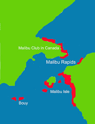
The Malibu Rapids forms the entrance to Princess Louisa Inlet and is also connected to the Jervis Inlet. The tidal flow of both inlets pass through this narrow and shallow passage that creates a fast moving and strong tidal rapids during the peak flows. At slack tide, the entrance is virtually flat calm similar to the Skookumchuck Narrows near the entrance of the Jervis Inlet.

MV Malibu Princess is a passenger vessel privately owned by Young Life and which operates the Malibu Club in Canada located at Malibu, British Columbia, adjacent to the narrow entrance of Princess Louisa Inlet. The ship is used specifically to transport people and freight to Malibu.

Malibu Islet, also known as Malibu Isle or Forbidden Island, is located at the entrance of Princess Louisa Inlet, south of Malibu Rapids, east of Queens Reach, a stretch of Jervis Inlet in the New Westminster Land District, British Columbia, Canada. The island is the part of the narrow passage that joins Princess Louisa Inlet and Jervis Inlet together. The navigational entrance to Princess Louisa Inlet for all marine traffic is between the island and a navigation buoy.
In Canada, a number of sites and structures are named for royal individuals, whether a member of the past French royal family, British royal family, or present Canadian royal family thus reflecting the country's status as a constitutional monarchy under the Canadian Crown. Those who married into the royal family are indicated by an asterisk (*). Charles Edward Stuart was a pretender to the British throne.

MV Malibu is a 100-foot (30 m) motor yacht built in 1926. She was designed by Ted Geary and built by N. J. Blanchard Boat Co., Seattle, Washington.