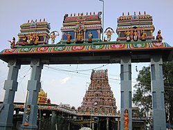
Omalur is a panchayat town and headquarters of Omalur taluk in the Salem District in the Indian state of Tamil Nadu. It is situated on the National Highway 7 between 11° 73333" latitude and 78° 06667" longitude. It has a population of about 13,600. Agriculture, leather and handloom textiles are the major businesses.

Janjgir–Champa district is a district in the Indian state of Chhattisgarh. The district headquarters of the district Janjgir–Champa, Janjgir, is the city of Maharaja Jajawalya Dev of the Kalachuri dynasty. Earlier a part of the Bilaspur district, Jangir was carved out in 1998 to a separate district of its own, and ran to a political controversy about the name of the freshly minted district, which it carries to date as the name "Janjgir–Champa". Inhabitants are generally migrants from nearby villages.

Namakkal District is one of the 38 districts in the state of Tamil Nadu, India. The district was bifurcated from Salem District with Namakkal town as headquarters on 25 July 1996 and started to function independently from 1 January 1997. The district has seven taluks (subdivisions): Tiruchengode, Namakkal, Rasipuram, Paramathi Velur, Sendamangalam, Kumarapalayam, Kolli Hills and Mohanur. It has two revenue divisions: Tiruchengode and Namakkal. As of 2011 census, Namakkal district had a population of 1,726,601 with a sex-ratio of 986 females for every 1,000 males and Tiruchengode is the largest city in terms of population. Namakkal district is geographically affiliated to Kongu Nadu region. The district is famous for its large poultry industry, egg production and lorry bodybuilding industry, for which it is often referred to as "Egg City" and "Transport Hub of South India".
Tiruchengode is a city and selection grade municipality located in southern Indian state of Tamil Nadu.
Singampunari is a Panchayat Union in Sivagangai district, in Tamil Nadu, India. The town comes under Singampunari taluk.
Avalpoondurai is a panchayat town in Erode district in the state of Tamil Nadu, India. It is situate 14 kilometres from Erode and an important junction on SH-83A en route to Dharapuram and other important small towns like Modakuruchi and Elumathur. It is about 415 km from Chennai,100 km from palani,100 km from Coimbatore, 50 km from Tiruppur and from Gobicheittipalayam.
Kalappanaickenpatti is a panchayat town in Namakkal district in the Indian state of Tamil Nadu
Karumathampatti is a Municipality in the Coimbatore district in the state of Tamil Nadu, India. It is one of the most developing suburb in Coimbatore about 25 km away from the city centre. It is situated in between NH544 which connects the city of Coimbatore with Salem – Erode – Tirupur and also in between the State Highway 165 connects Annur – Kamanaikenpalayam. Nearby places are Somanur-3 km, Avinashi-10 km, Tirupur-20 km, Sulur-15 km, Annur-16 km. Coimbatore -27,Mettupalayam-38,Palladam-19. Karumathampatti lies near the junction of two major roads, NH544(Coimbatore – Salem) and Karumathampatti – Annur road.
Mallur is a village or town council (panchayat) in the Salem district, which is located in the Indian state of Tamil Nadu.
Mohanur is a taluk in the Namakkal district of the Indian state of Tamil Nadu. The Mohanur Panchayat Union includes Mohanur Town, Pettapalayam, Manappalli, Rasipalayam, Kumaripalayam, Sengappalli, Ediyar, Peramandampalayam, Ariyur, Aniyapuram, and Valayapatti. It is linked to Tiruchirappalli, Salem, Erode, and Karur districts by road.
Othakkalmandapam is a suburb of Coimbatore city in the Indian state of Tamil Nadu. The suburb is known locally as O.K. Mandapam or O.K.M. It is located outside the city limits, which recently merged with the Corporation of Coimbatore up to Eachanari. Othakkalmandapam is located outside the city limits of Coimbatore.It belongs to kinathukadavu constituency.
Paramathi is a panchayat town in Namakkal district in the Indian state of Tamil Nadu. It is the headquarter of Paramathi block.
Tiruvaikuntam is a panchayat town in Thoothukudi district in the Indian state of Tamil Nadu. It is located on the banks of the river Thamirabarani.
Thammampatti Town Panchayat is a Upgraded Special-Grade Town with a panchayat status in the Salem District of Tamil Nadu, India. The town is located between Pachamalai and the Kolli Hills on the River Swetha, and is known mainly for its fine wood carvings.

Tharamangalam is a Municipality in Salem district in the Indian state of Tamil Nadu.
Paramathi Velur, a town in Paramathi-Velur taluk, Namakkal District, Tamil Nadu, India is situated just off the Srinagar - Kanyakumari National Highway 44 (India). This town is also called as Paramathi Velur, with STD Code 04268 & Postal code 638182.
Paramathi-Velur taluk is a taluk in the Namakkal district of the Indian state of Tamil Nadu. Paramathi Velur town is the headquarter of this Taluk.
Puduchatram is a town panchayat located in the Namakkal district of Tamil Nadu state, India. The latitude 11.384679 and longitude 78.162495 are the geocoordinates of Puduchatram. It is the headquarter of Puduchatram block.
Thachur is a village in kallakurichi district in the state of Tamil Nadu, India.It is a Grama Panchayat consisting of few villages.


