Manafwa

Last updated
Manafwa
Uganda location map.svg
Red pog.svg
Manafwa
Map of Uganda showing the location of Manafwa.
Coordinates: 00°55′11″N34°17′28″E / 0.91972°N 34.29111°E / 0.91972; 34.29111
CountryFlag of Uganda.svg  Uganda
District Manafwa District
Elevation
1,196 m (3,924 ft)
Population
 (2020 Estimate)
  Total16,000
Time zone UTC+3 (EAT)

Manafwa is a town in the Eastern Region of Uganda. It is the largest town in Manafwa District and the site of the district headquarters. [1]

Contents

Location

Manafwa is located approximately 32 kilometres (20 mi), by road, southeast of the city of Mbale, the largest metropolitan area in the sub-region. [2] This is approximately 247 kilometres (153 mi), northeast of Kampala, Uganda's capital and largest city. [3] The coordinates of Manafwa Town are 0°55'11.0"N, 34°17'28.0"E (Latitude:0.919723; Longitude:34.291099). Manafwa Town Council sits at an average elevation of 1,196 metres (3,924 ft), above mean sea level. The town is located within Mount Elgon National Park and is surrounded by tropical mountainous terrain. [4]

Population

The national population census in 2002 put the town population at about 11,740. In 2010, the Uganda Bureau of Statistics (UBOS) estimated the population at 15,400. In 2011, UBOS estimated the mid-year population at 15,800. [5]

In 2015, UBOS estimated the population of the town at 14,200. In 2020, the population agency estimate the mid-year population of Manafwa Town Council at 16,000. Of these, 8,200 (51.2 percent were female) and 7.800 (48.8 percent) were male. UBOS calculated that the town's population grew at an average rate of 2.4 percent annually, between 2015 and 2020. [6]

Historical population
YearPop.±%
200211,740    
201015,400+31.2%
201115,800+2.6%
201413,645−13.6%
201514,200+4.1%
202016,000+12.7%
source: [5] [6]

Points of interest

The following additional points of interest lie within the town limits or near the edges of town:

1. The offices of Manafwa Town Council

2. Manafwa Central Market

3. A mobile branch of PostBank Uganda

4. Manafwa River, immediately south of town

5. Stanbic Bank Uganda Limited maintains a branch in Manafwa town. [7]

See also

Related Research Articles

<span class="mw-page-title-main">Mbale</span> Place in Eastern Uganda, Uganda

Mbale is a city in the Eastern Region of Uganda. It is the main municipal, administrative, and commercial center of Mbale District and the surrounding sub-region.

<span class="mw-page-title-main">Moroto Town</span> Place in Northern Region, Uganda

Moroto is a town in Moroto District in the Northern Region of Uganda. The town serves as the location of the district headquarters.

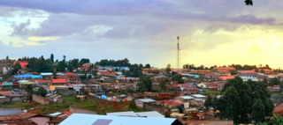
Budaka is a town in the Eastern Region of Uganda. It is the chief town of Budaka District, and the district headquarters are located there.

Pallisa is a town in Pallisa District of the Eastern Region of Uganda.

Bugiri is a town in the Eastern Region of Uganda. It is the chief town of Bugiri District, and the district headquarters are located there. The town was elevated to Municipal Council status in 2019.

<span class="mw-page-title-main">Bundibugyo</span> Town in Uganda

Bundibugyo is a town in the Western Region of Uganda. It is the 'chief town' of Bundibugyo District and the district headquarters are located there.

Katakwi is a town in the Eastern Region of Uganda. It is the main municipal, administrative, and commercial center of Katakwi District and the site of the district headquarters.

Kapchorwa is a town in the Eastern Region of Uganda. It is the main municipal, commercial, and administrative center of Kapchorwa District. Initially, the town of Kapchorwa was known as the Sebei Region.

Mpigi is a town in Mawokota County, Mpigi District, in Central Uganda. Mpigi is the municipal, administrative and commercial headquarters of Mpigi District. The district is named after the town.

Butaleja is a town in Eastern Region of Uganda. It is the main municipal, administrative and commercial center of Butaleja District and the district headquarters are located there. The district is named after the town.

Kumi Town, commonly called Kumi, is a town in the Eastern Region of Uganda. It is the main municipal, administrative, and commercial center in Kumi District and is the site of the district headquarters.

Malaba, Uganda is a town in Tororo District in the Eastern Region of Uganda, on its eastern border with Kenya. It sits adjacent from Malaba, Kenya, across the Malaba River that marks the border between Uganda and Kenya.

Busolwe is a town in the Eastern Region of Uganda. It is one of the two municipalities in Butaleja District, the other being Butaleja.

Bukedea is a town in the Eastern Region of Uganda. It is the chief municipal, administrative, and commercial center of Bukedea District, and the district headquarters are located there.

<span class="mw-page-title-main">Kaabong</span> Ugandan town

Kaabong is a town in the Northern Region of Uganda. It is the chief municipal, administrative and commercial center of the eponymous Kaabong District, and the district headquarters are located in the town.

Nagongera is a town in Tororo District, in the Eastern Region of Uganda.

Bududa is a town in the Eastern Region of Uganda. It is the main municipal, administrative, and commercial center of Bududa District.

Ngora is a town in the Eastern Region of Uganda. It is the main political, administrative, and commercial centre of Ngora District.

Lwakhakha is a town in the Eastern Region of Uganda. It is one of the municipal centers in Manafwa District. The town lies across the international border from Lwakhakha, Kenya.

Bumbobi–Bubulo–Lwakhakha Road is a road in the Eastern Region of Uganda, connecting the city of Mbale to the town of Lwakhakha at the International border with Kenya.

References

  1. Geonames (1 May 2021). "Manafwa Town Council Is An Urban Centre In Bubulo West, Manafwa District, Eastern Region, Uganda". Geonamemes.org. Retrieved 1 May 2021.
  2. Google (1 May 2021). "Road Distance Between Manafwa, Eastern Region, Uganda and Mbale, Eastern Region, Uganda" (Map). Google Maps . Google. Retrieved 1 May 2021.
  3. Google (1 May 2021). "Road Dstance Between Kampala, Uganda And Manafwa, Uganda" (Map). Google Maps . Google. Retrieved 1 May 2021.
  4. Google (29 May 2016). "Location of Manafwa Town, Manafwa District, Eastern Region, Uganda" (Map). Google Maps . Google. Retrieved 29 May 2016.
  5. 1 2 Uganda Bureau of Statistics (7 July 2014). "Estimated Population of Manafwa In 2002, 2010 & 2011" (PDF). Kampala: Uganda Bureau of Statistics. Archived from the original (Archived from the original on 7 July 2014) on 2014-07-07. Retrieved 1 May 2021.
  6. 1 2 Uganda Bureau of Statistics (14 June 2020). "The population development of Manafwa as well as related information and services" (Citypopulation.de Quoting Uganda Bureau of Statistics). Citypopulation.de. Retrieved 1 May 2021.
  7. Google (29 May 2016). "Location of Stanbic Bank, Manafwa, Eastern Region, Uganda" (Map). Google Maps . Google. Retrieved 29 May 2016.

00°57′23″N34°17′04″E / 0.95639°N 34.28444°E / 0.95639; 34.28444