This article has multiple issues. Please help improve it or discuss these issues on the talk page . (Learn how and when to remove these messages)
|
Mandal | |
---|---|
Village | |
Coordinates: 30°27′18″N79°16′30″E / 30.455°N 79.275°E | |
Country | India |
State | Uttarakhand |
District | Chamoli |
Government | |
• Type | Gram Panchayat |
Area | |
• Total | 1.2 km2 (0.5 sq mi) |
Elevation | 1,500−1,700 m (−4,100 ft) |
Population (2011) [1] | |
• Total | 452 |
Languages | |
• Official | Hindi, Garhwali |
Time zone | UTC+5:30 (IST) |
PIN | 246401 [2] |
Vehicle registration | UK-11 |
Website | uk |
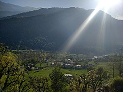
Mandal [3] is a village in the Garhwal Himalayas of Uttarakhand, India.
According to Census 2011 information the location code or village code of Mandal village is 040908. Mandal village is located in Chamoli Tehsil of Chamoli district in Uttarakhand, India. It is situated 23 km away from sub-district headquarter Chamoli and 13 km away from district headquarter Gopeshwar. Mandal village is also a gram panchayat. [4]
The total geographical area of village is 119.42 hectares. Mandal has a total population of 452 peoples. There are about 108 houses in village. As per 2019 stats, Mandal villages comes under Badrinath assembly & Garhwal parliamentary constituency. Gopeshwar is nearest town to Mandal which is approximately 13 km away. [5]
Badrinath is a town and nagar panchayat in Chamoli district in the state of Uttarakhand, India. It is a Hindu holy place, and is one of the four sites in India's Char Dham pilgrimage. It is also part of India's Chota Char Dham pilgrimage circuit and gets its name from the Badrinath Temple.
Joshimath, also known as Jyotirmath, is a town and a municipal board in Chamoli District in the Indian state of Uttarakhand. Located at a height of 6,150 feet, it is a gateway to several Himalayan mountain climbing expeditions, trekking trails and pilgrim centres like Badrinath. It is home to one of the four cardinal pīthas established by Adi Shankara.
Chamoli district is a district of the Uttarakhand state of India. It is bounded by the Tibet region to the north, and by the Uttarakhand districts of Pithoragarh and Bageshwar to the east, Almora to the south, Pauri Garhwal to the southwest, Rudraprayag to the west, and Uttarkashi to the northwest. The administrative headquarters of Chamoli district is in Gopeshwar.
Almora is a district in the Kumaon Division of Uttarakhand state, India. The headquarters is at Almora. It is 1,638 meters above sea level. The neighbouring regions are Pithoragarh district to the east, Chamoli district to the west, Bageshwar district to the north and Nainital district to the south.
Gairsain is a town in Chamoli district of the Indian state of Uttarakhand near state's summer capital Bhararisain. A town and Nagar Panchayat, Gairsain is situated at the eastern edge of the vast Dudhatoli mountain range, and is located in Chamoli district almost at the centre of the state, at a distance of approximately 250 kilometres from Dehradun. It is easily accessible from both the Garhwal and the Kumaon divisions, and in a way, acts as the bridge between the two regions. It is being considered as the future Permanent capital of Uttarakhand.
Pauri Garhwal is a district in the Indian state of Uttarakhand. Its headquarters is in the town of Pauri. It is sometimes referred to simply as Garhwal district, though it should not be confused with the larger Garhwal region of which it is only a part of.
Tehri Garhwal is a district in the hill state of Uttarakhand, India. Its administrative headquarters is at New Tehri. The district has a population of 618,931, a 2.35% increase over the previous decade. It is surrounded by Rudraprayag District in the east, Dehradun District in the west, Uttarkashi District in the north, and Pauri Garhwal District in the south. Tehri Garhwal is a part of the Himalayas.
Rudraprayag is a district of the state of Uttarakhand of northern India. The district occupies an area of 1984 km2. The town of Rudraprayag is the administrative headquarters of the district. The district is bounded by Uttarkashi District on the north, Chamoli District on the east, Pauri Garhwal District on the south, and Tehri Garhwal District on the west.
Chamoli Gopeshwar is a township in the Garhwal hills and a municipal board within Chamoli district. It is the administrative headquarters of the Chamoli District of Uttarakhand in India. Located 1,450 m (4,760 ft) above sea level. It is famous for its weather which is pleasant most of the year but very cold in December and January. Chamoli Gopeshwar is known for his very beautiful temple, Shri Gopinath mandir that has a definite special feeling to it. Chamoli Gopeshwar has a very beautiful water storage facility (kund) called Vaitrani.
Gauchar is a Hill Town sort of a valley town located in Karnaprayag tehsil within Chamoli district of Uttarakhand state in India. Gauchar is situated on the left bank of river Alaknanda and is en route to the celebrated holy destination of Badrinath. It is well known for being one of the cleanest place in country. It has previously topped Swachta sarvekshan best ganga town award. Situated at an altitude of 800 metres (2,620 ft) above the sea level, Gauchar is surrounded by seven mountains. Gauchar is well known for its historic trade fair and airstrip. Gauchar town known for its great work to curb loss of lives in 2013 flood disaster of Uttarakhand. This town is unique in terms of its geographical location and topography. Gauchar is located on one of the largest pieces of flatland in this mountainous region of Uttarakhand. Education institution in Gauchar includes a beautiful Kendriya Vidyalaya adjacent to the main playground.
Kausani is a hill station and Village situated in Bageshwar district in the state of Uttarakhand, India. It is known for its scenery and its 300 km-wide panoramic view of Himalayan peaks like Trisul, Nanda Devi and Panchchuli. Mahatma Gandhi called this place the 'Switzerland of India', due to similarity in landscapes.
Chandi Prasad Bhatt is an Indian environmentalist and social activist, who founded Dasholi Gram Swarajya Sangh (DGSS) in Gopeshwar in 1964, which later became a mother-organization to the Chipko Movement, in which he was one of the pioneers. For his work Bhatt was awarded the Ramon Magsaysay Award in 1982, followed by the Padma Bhushan in 2005.
Gwaldam is a hill station in India, situated between the Garhwal and Kumaon, 39 km (24 mi) from Kausani.
The 1999 Chamoli earthquake occurred on 29 March in the Chamoli district in the Indian state of Uttar Pradesh. Approximately 103 people died in the earthquake.
Rudranath Temple is a Hindu temple dedicated to God Shiva, located in the Garhwal Himalayan mountains in Uttarakhand, India. Located at 3,600 metres (11,800 ft) above sea level, this natural rock temple is situated within a dense forest of rhododendron dwarfs and Alpine pastures. The temple is the fourth temple to be visited in the Panch Kedar pilgrimage circuit, comprising five Shiva temples in the Garhwal region to be visited in a strict pecking order starting with Kedarnath at an altitude of 3,583 m, the Tungnath (तुंगनाथ)(3,680 m or 12,070 ft), Rudranath (रुद्रनाथ), Madhyamaheshwar (मध्यमहेश्वर) and Kalpeshwar (कल्पेश्वर).
Mehalchauri is a village in Gairsain Tehsil located in Chamoli district in the Indian state of Uttarakhand. It is situated in Garhwal mandal nearby the center of the Garhwal and Kumaon mandal.
Akhori is a village in Bhilangana block of Tehri Garhwal district, Uttarakhand, India. As of 2011, it has a population of 1,623 people, in 324 households, and 2 primary school, 1 highschool and 1 Intermediate College. The village lands cover an area of 326.8 hectares. The nearest major town is Ghansali.
Mantri Prasad Naithani is an Educational and Minister of Water Resources in Uttarakhand, India. He was former Cabinet Minister in the cabinet of N. D. Tiwari in the year 2002. Again he was voted in the Devprayag Legislative election and deputed for the Cabinet Minister in Uttarakhand. The address of his Legislative area is Village Sankro (Chauraas), Vikaskhand Kirtinagar, Tehri Garhwal.
Kadalaveni is a village in the southern state of Karnataka, India. It is located in the Gauribidanur taluk of Chikkaballapura district in Karnataka. It is situated 6 km away from sub-district headquarter Gauribidanur and 44 km away from district headquarter Chikkaballapura
Thondebhavi is a village in the southern state of Karnataka, India. It is located in the Gauribidanur taluk of Chikkaballapura district in Karnataka. It is situated 13 km away from sub-district headquarter Gauribidanur and 25 km away from district headquarter Chikkaballapura