
Chandrapur district is a district in the Nagpur Division in the Indian state of Maharashtra. Chandrapur was the largest district in India until the Gadchiroli and Sironcha tehsils were separated as Gadchiroli district in 1981. In 2011, the district population was 2,204,307.

Osmanabad District is an administrative district in the Marathwada region in the Indian state of Maharashtra. The district headquarter is located at Osmanabad. The District of Osmanabad derives its name from the last ruler of Hyderabad, the 7th Nizam, Mir Osman Ali Khan, of which the region was a part till 1947. This region was earlier part of The Hyderabad State until Independence.This primarily rural district occupies an area of 7,569 km2 (2,922 sq mi) of which 241.4 km2 (93.2 sq mi) is urban and has a population of 1,657,576 of which 16.96% were urban.

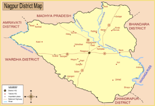
Nagpur district is a district in the Vidarbha region of Maharashtra state in central India. The city of Nagpur is the district administrative centre. The district is part of Nagpur Division.
Bhandara is a city and municipal council which serves the administrative headquarters of eponymous administrative Bhandara Taluka and Bhandara district in the state of Maharashtra, India. It is connected with NH-53 and NH-247.
Hala is a city and taluka of Matiari district of Sindh, Pakistan. According to the Revenue record, Hala was given the status of Taluka of Hyderabad District in 1848. In 2005, it became part of Matiari District. Hala is located on the N-5 National Highway of Pakistan at a distance of about 62 kilometers from Hyderabad. Hala is also located on the Tando Adam - Mehrabpur Railway Line but railway line has been abandoned by Pakistan Railways. As of 2017 census, the Hala Municipal Corporation has a population of 65,731. Total population of Hala Taluka is 262,423 (2017) which includes Hala Municipal Corporation, Hala Old, Bhit Shah, Bhanote and surrounding areas.
Matyari or Matiari is a city located in Sindh, Pakistan. It is 30 km (19 mi) north of Hyderabad on N-5 National Highway. Matiari is also the district headquarter of Matiari District.

Chikkodi is a taluka and Town Municipal Council in the Belagavi district of Karnataka, India. It is a Subdivision of the district. Chikodi, Athani, Hukkeri, Raybag, Nipani and Kagwad are the taluks that come under Chikodi Subdivision. It is 75 kilometers from the city of Belgaum, 65 kilometers from Kolhapur, 51 kilometers from Miraj, 160 kilometers from Hubballi, and 570 kilometers from the capital of Karnataka state, Bengaluru. Chikodi has many district level offices but it is not designated as a district by the Government of Karnataka. It is one of the major cities that lies in the border between Karnataka and Maharashtra states.official language is Kannada.

Kalameshwar-Bramhani is a city and a municipal council also a major Industrial hub in Nagpur district in the Indian state of Maharashtra. It is connected to National Highways NH-353I, NH-353J & NH-547E.
Kinwat is a city which falls under the municipal council of the Nanded District, in the Indian state of Maharashtra. The Kinwat Taluka came into existence in 1905 when a number of villages from Narsapur,Tamsi, and Nirmal Talukas from the Adilabad District, were combined. Earlier, these villages were under the Hyderabad Division. In 2011, Kinwat had population of 28454 with literacy rate of 82% and female sex ratio of 929. Kinwat is 125 km away from Nanded city. Kinwat has Rural Hospital.
Narkhed is a town and a municipal council in Nagpur district in the Indian state of Maharashtra. It is about 87 km north-west of Nagpur. It is the administrative headquarters of Narkhed taluka, one of the 14 talukas of this district. It is located in the "orange belt" and is a major center for orange-trading.
Parseoni is a town and a tehsil in Ramtek subdivision of Nagpur district in Nagpur revenue Division in the Berar region in the state of Maharashtra, India.
Peth or Peint is the smallest tehsil of Nashik subdivision of Nashik district in Maharashtra, India. It belongs to Northern Maharashtra region. It belongs to Nashik Division. Peth is a Taluka headquarter. It is located 54 km to the West of Nashik District headquarters. It is also called as Peint. Pin code of Peth is 422208 and postal head office is Peth.

Dhari is a town in Amreli District in Indian state of Gujarat, India. It is an administrative headquarter of the Dhari tehsil(almost 87 villages and ness).Dhari is the most populous town in Amreli District as per census 2011 with 30352 population. Dhari is located on the bank of Shetrunji River, 42 km(26.2 mi) from district headquarter Amreli & 318 km(199.8 mi) from state capital Gandhinagar. Dhari is famous for kesar mango and Asiatic lion. Dhari is capital of East Gir Forest.
Gobindpur is a village located in southern part of Karra block, Khunti district. It is 50 kilometres from Ranchi, the capital of Jharkhand state.
Malegaon Jahangir is a big town and headquarters of Malegaon taluka in Washim subdivision of Washim district of Maharashtra state in India. It is located on the state highway joining south-east Maharashtra and Vidarbha to southern India. Malegaon is on the main road which is between Washim and Mehkar. It is a major junction for road-based transport.

Gadhinglaj is a taluka in Maharashtra. The city of Gadhinglaj is the taluka headquarters and Gadhinglaj subdivision headquarters as well. As of 2011, the taluka had a population of 874,015, of which 35% were urban. Languages spoken in this area are Marathi, Kannada, Hindi and English also. But the most-spoken language is Marathi, as Marathi is a state language.

The Kolar River is a river of Nagpur district, Maharashtra, India, flowing southeast from above the town of Saoner to its juncture with the Kanhan River. It is in the Godavari river basin. The Kolar River forms the boundary between Saoner taluka and Ramtek taluka.

Ambhora is a village situated in the Kuhi taluka of Nagpur district in the Indian state of Maharashtra. As of the 2011 Indian census, it had a population of 530.
Mansurchak is a town in Mansurchak Block in Begusarai District of Bihar, India. It belongs to Munger division.