
Nagpur is the third largest city and the winter capital of the Indian state of Maharashtra. It is the 13th largest city in India by population and according to an Oxford's Economics report, Nagpur is projected to be the fifth fastest growing city in the world from 2019 to 2035 with an average growth of 8.41%. It has been proposed as one of the Smart Cities in Maharashtra and is one of the top ten cities in India in Smart City Project execution.

Vidarbha is a geographical region in the east of the Indian state of Maharashtra and a proposed state of central India, comprising the state's Amravati and Nagpur divisions. Amravati Division's former name is Berar. It occupies 31.6% of the total area and holds 21.3% of the total population of Maharashtra. It borders the state of Madhya Pradesh to the north, Chhattisgarh to the east, Telangana to the south and Marathwada and Uttar Maharashtra regions of Maharashtra to the west. Situated in central India. The largest city in Vidarbha is Nagpur followed by Amravati, Akola, and Chandrapur. A majority of Vidarbhians speak Varhadi and Zadi dialects of Marathi.
Amravati is the second largest city in the Vidarbha region and ninth largest city in Maharashtra, India. It is administrative headquarters of Amravati district and Amravati division which includes Akola, Buldhana, Washim, and Yavatmal districts. It is one of the Maharashtra's nominated city under Smart Cities Mission.
Akola is a municipal corporation and the third largest city in Vidarbha after Nagpur and Amravati and tenth largest city in Maharashtra. is located about 580 kilometres (360 mi) east of the state capital, Mumbai, and 250 kilometres (160 mi) west of the second capital, Nagpur. Akola is the administrative headquarters of the Akola district located in the Amravati division, and is governed by the Akola Municipal Corporation.

Buldhana district is located in the Amravati division of Maharashtra, India. It is situated at the western border of Vidarbha region and is 500 km away from the state capital, Mumbai. The district has towns and cities like Shegaon, Jalgaon Jamod, Malkapur, Khamgaon, Lonar, Mehkar, and Chikhli. It is surrounded by Madhya Pradesh in the north, Akola, Washim, and Amravati districts on the east, Jalna district on the south, and Jalgaon and Aurangabad districts on the west. Khamgaon is the largest city in the district. Latitudes are 19.51° to 21.17° N and longitudes are 75.57° to 76.59° E.

Chandrapur district is a district in the Nagpur Division in the Indian state of Maharashtra. Chandrapur was the largest district in India until the Gadchiroli and Sironcha tehsils were separated as Gadchiroli district in 1981. In 2011, the district population was 2,204,307.
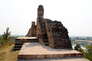
Bhandara District is an administrative district in the state of Maharashtra in India. The district headquarters are located at Bhandara. The district occupies an area of 3717 km2 and has a population of 1,200,334, of which 19.48% are urban as of 2011. The growth rate of Bhandara is 5.56% Bhandara has a mixed economy with agriculture, industries and forest resources. Bhandara is known for its large production of rice. Tumsar, a tahsil town, is a noted rice market. Bhandara town is also known as "Brass City" owing to the presence of a large brass products industry. Bhandara has several tourist destinations, like Ambagad Fort, Brahmi, Chinchgad, and Dighori.

Yavatmal (pronunciation is a city and municipal council in the Indian state of Maharashtra. It is the administrative headquarters of Yavatmal District. Yavatmal is around 90 km away from divisional headquarters Amravati while it is 670 km away from the state capital Mumbai. The name is derived from the Marathi Yavat and mal. Another theory is it might be derived from Yavateshwar and Mal as the city is located on a plateau, which is comparatively higher altitude than its other tehsils.

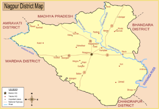
Nagpur district is a district in the Vidarbha region of Maharashtra state in central India. The city of Nagpur is the district administrative centre. The district is part of Nagpur Division.
Bhandara is a city and municipal council which serves the administrative headquarters of eponymous administrative Bhandara Taluka and Bhandara district in the state of Maharashtra, India. It is connected with NH-53 and NH-247.

Kalameshwar-Bramhani is a city and a municipal council also a major Industrial hub in Nagpur district in the Indian state of Maharashtra. It is connected to National Highways NH-353I, NH-353J & NH-547E.

Mohpa is a city with a municipal council in Nagpur district in the Indian state of Maharashtra. Although physically located within Kalmeshwar taluka, it is not subject to taluka governance. It is divided in to basically three part
Morshi is the second largest town in the Amravati district of Maharashtra, India. It is located 55 km north-east of Amravati, situated very close to the border with Madhya Pradesh, in the scenic southern foothills of the Satpura ranges. Morshi and the surrounding region is also known for the cultivation of Nagpur oranges and the prominent Nal Damayanti Dam.

Ramtek is a city and municipal council in Nagpur district of Maharashtra, India.
Umred is a town and a municipal council in the Nagpur district of Maharashtra, India. According to the 2011 census the city has a population of 53971.

Jalnapronunciation (help·info) is a city in Jalna district in the Aurangabad Division, or Marathwada region, of the Indian state of Maharashtra. It was part of Hyderabad State as a tehsil of Aurangabad district, before Jalna district was formed effective 1 May 1981.
Saoner is a city and tehsil headquarters in north part of Nagpur district in state of Maharashtra, India. The town is governed by Savner municipal council. It is 36 kilometres (22 mi) from Nagpur city. Saoner is located on the bank of Kolar River. It is historically and mythologically important.
Hingna is a town, tehsil and taluka in Nagpur district in Maharashtra state. Now Hingna is part of Nagpur Metropolitan Region and emerging as an industrial suburb of Nagpur city due to presence of various industrial developments. The Nagpur revenue division is part of Berar region in the state.
Parseoni is a town and a tehsil in Ramtek subdivision of Nagpur district in Nagpur revenue Division in the Berar region in the state of Maharashtra, India.
Umred-Pauni-Karhandla Wildlife Sanctuary, about 50 km from Nagpur and 60 km from Bhandara, is spread over Pauni Tahsil of Bhandara district and Umred, Kuhi and Bhivapur Taluka of Nagpur district. This sanctuary has a connection with Tadoba Andhari Tiger Reserve through the forest along Wainganga river. The sanctuary is home to resident breeding tigers, herds of Gaur, wild dogs and rare animals like flying squirrels, pangolins and honey badgers.
as a citizen of Nagpur...

