Tangiwai is a rural community in the Ruapehu District of the Manawatu-Wanganui Region of New Zealand's North Island. It is located east of Ohakune and Rangataua and west of Waiouru on State Highway 49.

The town of Pauanui is on the east coast of the Coromandel Peninsula in the North Island of New Zealand. It lies at the mouth of the Tairua River on its south bank, directly opposite the larger town of Tairua. The population was 750 in the 2013 New Zealand census, an increase of 9 from 2006.

Opiki is a small rural settlement in the Horowhenua district of New Zealand's North Island. It is located on the floodplain of the Manawatu River, 15 km (9 mi) southwest of Palmerston North.

Arapuni is a rural town centre on the Waikato river in the South Waikato District of New Zealand. The population on census night 2006 was 2,145 usual residents, slightly down from 2,163 in 2001 and 2,211 in 1996.
The Makotuku River is a river of the west of New Zealand's North Island. It flows southwest from the slopes of Mount Ruapehu and passes through the town of Raetihi before its confluence with the Mangawhero River.
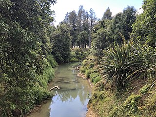
The Manganui o te Ao River is a river of the centre of New Zealand's North Island. It has its source in numerous streams and small rivers which flow west from the slopes of Mount Ruapehu, though the main course of the river flows predominantly southwest through rugged hill country to meet with the Whanganui River 10 kilometres (6 mi) north of Pipiriki, at the edge of the Whanganui National Park.
The Mangapu River is a river of the Waikato region of New Zealand's North Island. It has its sources in numerous streams which flow generally northwards from the King Country south of Te Kuiti, the longest of which is the Mangaokewa Stream. These streams join to form the Mangapu close to Te Kuiti, and from here the river flows north, passing close to the east of Waitomo Caves, where the Mangapu caves have the largest entrance in the North Island, before flowing into the Waipa River at Otorohanga.

The Mangatawhiri River is a river of the Auckland and Waikato regions of New Zealand's North Island. It flows generally southwest from its sources in the Hunua Ranges southeast of Clevedon before flowing through a system of irrigation canals at the northern edge of the Waikato Plains close to the town of Pokeno. It reaches the Waikato River close to the township of Mercer.
The Oparau River is a river of the Waikato Region of New Zealand's North Island. It flows southwest from its sources in the Pirongia Forest Park and flows into the Kawhia Harbour 5 kilometres (3 mi) east of Kawhia.

The Orere River is a river of the Auckland Region of New Zealand's North Island. It flows generally northeast from the Hunua Ranges, reaching the Firth of Thames at Orere Point, close to the point where the firth widens into the Hauraki Gulf.
The Otahu River is a river of the Coromandel Peninsula, in the Waikato Region of New Zealand's North Island. It flows generally northeast from several streams with watersheds in the Coromandel Range, most notably the Wharekirauponga Stream. The Otahu reaches the sea immediately to the south of the town of Whangamata.
The Waikakaho River is a river of the Marlborough Region of New Zealand's South Island. It flows south from its sources southeast of Havelock to reach the Wairau River 5 kilometres (3 mi) west of Tuamarina.
The Turanganui River is a river in the Wellington Region of New Zealand. It flows through the south Wairarapa from its source in the Aorangi Range to reach the Ruamahanga River shortly before the latter's outflow into Palliser Bay.
The Waikawau River is the name of two rivers of the Coromandel Peninsula in New Zealand's North Island. The more southerly flows generally west from its sources in the Coromandel Range, reaching the Firth of Thames 2 kilometres (1.2 mi) north of Tapu. The other flows south east off the Moehau Range to join the Pacific at Waikawau.

Ellis and Burnand was a New Zealand sawmilling and timber retailing company, formed by businessman John William Ellis and engineer Harry Burnand in 1891.

Ongarue is a rural community in the Ruapehu District and Manawatu-Wanganui Region of New Zealand's North Island. It is located south of Te Kuiti and Waimiha, and north of Taumaranui.
Ngapuke or Ngāpuke is a village and rural community, located east of Taumaranui and west of Tongariro and Kuratau on State Highway 41.
Waihaha or Waihāhā is a village and rural community in the Taupo District and Waikato region of New Zealand's North Island.
Puketotara, or Puketōtara, is a rural community in the Otorohanga District and Waikato region of New Zealand's North Island.

Waikeria is a rural community in the Otorohanga District and Waikato region of New Zealand's North Island.
