
The Waikato River is the longest river in New Zealand, running for 425 kilometres (264 mi) through the North Island. It rises in the eastern slopes of Mount Ruapehu, joining the Tongariro River system and flowing through Lake Taupō, New Zealand's largest lake. It then drains Taupō at the lake's northeastern edge, creates the Huka Falls, and flows northwest through the Waikato Plains. It empties into the Tasman Sea south of Auckland, at Port Waikato. It gives its name to the Waikato region that surrounds the Waikato Plains. The present course of the river was largely formed about 17,000 years ago. Contributing factors were climate warming, forest being reestablished in the river headwaters and the deepening, rather than widening, of the existing river channel. The channel was gradually eroded as far up river as Piarere, leaving the old Hinuera channel through the Hinuera Gap high and dry. The remains of the old river path can be clearly seen at Hinuera where the cliffs mark the ancient river edges. The river's main tributary is the Waipa River, which has its confluence with the Waikato at Ngāruawāhia.
Huntly is a town in the Waikato district and region of the North Island of New Zealand. It is on State Highway 1, 95 kilometres (59 mi) south of Auckland and 32 kilometres (20 mi) north of Hamilton. It is situated on the North Island Main Trunk (NIMT) railway and straddles the Waikato River. Huntly is within the Waikato District which is in the northern part of the Waikato region local government area.

Pukekohe is a town in the Auckland Region of the North Island of New Zealand. Located at the southern edge of the Auckland Region, it is in South Auckland, between the southern shore of the Manukau Harbour and the mouth of the Waikato River. The hills of Pukekohe and nearby Bombay Hills form the natural southern limit of the Auckland region. Pukekohe is located within the political boundaries of the Auckland Council, following the abolition of the Franklin District Council on 1 November 2010.
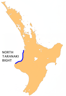
The North Taranaki Bight is a large bay that extends north and east from the north coast of Taranaki in New Zealand's North Island. The name is echoed by the South Taranaki Bight to the south of Cape Egmont.

Mokau is a small town on the west coast of New Zealand's North Island, located at the mouth of the Mokau River on the North Taranaki Bight. Mokau is in the Waitomo District and Waikato region local government areas, just north of the boundary with the New Plymouth District and the Taranaki Region. Prior to 1989, the town was classed as being in Taranaki, and there is still a feeling that the community of interest is most associated with New Plymouth, 90 km to the southwest. State Highway 3 passes through the town on its route from Te Kuiti to Waitara and, eventually, New Plymouth.

The East Coast Main Trunk (ECMT) is a railway line in the North Island of New Zealand, originally running between Hamilton and Taneatua via Tauranga, connecting the Waikato with the Bay of Plenty. The ECMT now runs between Hamilton and Kawerau, with a branch line to Taneatua from the junction at Hawkens. The line is built to narrow gauge of 1,067 mm, the uniform gauge in New Zealand. It was known as the East Coast Main Trunk Railway until 2011, when the word "Railway" was dropped.

Ngaere is a village situated on State Highway 3, 4 kilometres (2.5 mi) south of Stratford, New Zealand. The name "Ngaere" literally means "swamp" in English, and before settlement, the area was covered by a vast and ancient wetland.
Mokoia is a small settlement in south Taranaki, in the western North Island of New Zealand. It is located on State Highway 3, 10 kilometres (6.2 mi) to the east of Hāwera and about 17 km northwest of Patea.

Ōakura is a small township in New Plymouth District, Taranaki, in the western North Island of New Zealand. It is located on State Highway 45, 15 kilometres south-west of New Plymouth. Ōkato is 12 km further south-west. The Oakura River flows past the town and into the North Taranaki Bight. To the south is the Kaitake Range, part of Egmont National Park.

Onaero is a settlement in northern Taranaki, in the North Island of New Zealand. It is located on State Highway 3 close to the shore of the North Taranaki Bight, 15 kilometres (9.3 mi) east of Waitara. Onaero was the site of the No. 2 Company Redoubt, a British military installation created during the Second Taranaki War by soldiers from the Tikorangi Redoubt in 1865, however it was abandoned several months later.
Tongapōrutu is a settlement in northern Taranaki, in the North Island of New Zealand. It is located on State Highway 3 at the mouth of the Tongaporutu River, 15 kilometres south of Mokau. Tongapōrutu is well known in New Zealand for its 'Three Sisters' rock formations and its Māori petroglyphs carved into cave rock walls. However, both the Māori rock carvings and the 'Three Sisters formations are constantly being eroded by the Tasman Sea.
Awakino is a settlement in the south of Waitomo District, in the North Island of New Zealand. It is located on State Highway 3 at the mouth of the Awakino River, five kilometres north of Mokau. It is 79 km southwest of Te Kuiti, and 98 km northeast of New Plymouth.

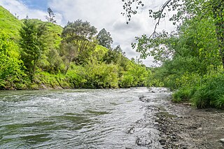
The Awakino River is a river located in the North Island of New Zealand. It has been described as one of the great rivers in the North Island providing top-quality backcountry fishing. Awakino township lies on its river banks. It rises on peaks of up to 762 m (2,500 ft) in the Herangi Range and flows 75 km (47 mi), initially southerly and then through Awakino Gorge in a south-westerly direction.
The Mangaotaki River is a river of the southern Waikato region of New Zealand's North Island. It flows generally southeast from its sources in the coastal Herangi Range to reach the Mokau River 15 kilometres (9 mi) southwest of Piopio.

The Mōhakatino River is a river in the northern Taranaki region of New Zealand's North Island. It flows generally west from its origins west of Ōhura, roughly paralleling the course of its northerly neighbour, the larger Mokau River. The Mōhakatino reaches the Tasman Sea 3 kilometres (2 mi) south of Mokau.
The Ōpārau River is a river of the Waikato Region of New Zealand's North Island in the area occupied by Ngāti Hikairo. It flows southwest from its sources in the Pirongia Forest Park, the highest being The Cone, and flows into the Kāwhia Harbour, 5 kilometres (3 mi) east of Kāwhia. The river has about 171 km (106 mi) of tributaries.

The Tongapōrutu River is a river of the Taranaki region of New Zealand's North Island. It initially flows north from its origins near Tahora, turning west to reach the Tasman Sea coast close to the settlement of Tongapōrutu, 15 kilometres (9.3 mi) south of Mokau.
The Waingaro River is a river of the Waikato region of New Zealand's North Island. It flows generally southwest from its origins near Glen Afton and Glen Massey, west of Ngāruawāhia, to reach a northern arm of Raglan Harbour. Its main tributary is Kahuhuru Stream, which Highway 22 follows for several kilometres. Tributaries total about 170 kilometres (110 mi). At Waingaro it is fed by a hot spring.

The Awaroa River is a short river in the Waikato District of New Zealand's North Island. It flows east from its source in the dunes near Karioitahi Beach and Lake Puketi, then south from Waiuku joining with the Aka Aka Stream before reaching the Waikato River in its tidal reaches close to Motutieke Island.
The Wairere Power Station is a hydroelectric power facility in the Waikato region in New Zealand which makes use of water from the Mokau River. Water is drawn from behind a dam above the Wairere Falls, which diverts the water through two penstocks to the Wairere Power Station, before being discharged back into the Mokau River. The station was commissioned in 1925 with the first generating unit. Three more generating units were added between 1938 and 1981 before a major refurbishment resulted in three of the units being replaced by a single generating unit in 2013-2014.
