
Waikato is a local government region of the upper North Island of New Zealand. It covers the Waikato District, Waipa District, Matamata Piako District, South Waikato District and Hamilton City, as well as Hauraki, Coromandel Peninsula, the northern King Country, much of the Taupo District, and parts of Rotorua District. It is governed by the Waikato Regional Council.
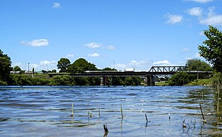
Ngāruawāhia is a town in the Waikato region of the North Island of New Zealand. It is located 20 kilometres (12 mi) north-west of Hamilton at the confluence of the Waikato and Waipa Rivers, adjacent to the Hakarimata Range. Ngaruawahia lies within the Hamilton Urban Area, the fourth largest urban area in New Zealand. The location was once considered as a potential capital of New Zealand.

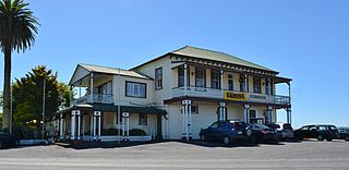
Tuakau is a town in the Waikato region, formerly part of the Auckland Region until 2010, when it became part of Waikato District in the North Island of New Zealand. The town serves to support local farming, and is the residence of many employees of New Zealand Steel at Glenbrook.

The Hunua Ranges form a block of hilly country to the southeast of Auckland in New Zealand's North Island. They cover some 250 square kilometres (97 sq mi), containing 178 km² of parkland, and rise to 688 metres (2255 ft) at Kohukohunui. Auckland gets much of its water from reservoirs within the Hunua Ranges. The ranges contain many rivers and streams, including the Hunua Falls on the Wairoa River, which is a popular tourist and local spot in the Ranges.
The Waiapu River is a river in the Gisborne District of the North Island of New Zealand, with a total length of approximately 130 kilometres (81 mi). Found in the north-east of the Waiapu Valley, it flows north-east from the joining of the Mata River and the Tapuaeroa River, then passes by Ruatoria before reaching the Pacific Ocean at Rangitukia. Other tributaries of the Waiapu River include the Mangaoporo, Poroporo, Wairoa, Maraehara rivers, and the Paoaruku stream. It is the most well known river in the region, and lies within the rohe (territory) of Ngāti Porou, the largest iwi on the East Coast, and second largest in New Zealand. The area was the site of hostilities during the New Zealand Wars from June to October in 1865, both between Pākehā and Māori, and between factions of Ngāti Porou.
The Manganui o te Ao River is a river of the centre of New Zealand's North Island. It has its source in numerous streams and small rivers which flow west from the slopes of Mount Ruapehu, though the main course of the river flows predominantly southwest through rugged hill country to meet with the Whanganui River 10 kilometres (6 mi) north of Pipiriki, at the edge of the Whanganui National Park.
For the sawmill area of Mangapehi see Ellis and Burnand#Mangapehi
The Mangapu River is a river of the Waikato region of New Zealand's North Island. It has its sources in numerous streams which flow generally northwards from the King Country south of Te Kuiti, the longest of which is the Mangaokewa Stream. These streams join to form the Mangapu close to Te Kuiti, and from here the river flows north, passing close to the east of Waitomo Caves, where the Mangapu caves have the largest entrance in the North Island, before flowing into the Waipa River at Otorohanga.
The Oparau River is a river of the Waikato Region of New Zealand's North Island. It flows southwest from its sources in the Pirongia Forest Park and flows into the Kawhia Harbour 5 kilometres (3 mi) east of Kawhia.

The Orere River is a river of the Auckland Region of New Zealand's North Island. It flows generally northeast from the Hunua Ranges, reaching the Firth of Thames at Orere Point, close to the point where the firth widens into the Hauraki Gulf.
The Oruawharo River is a river on the North Auckland Peninsula of New Zealand. It flows westward into the Kaipara Harbour west of Wellsford. It forms part of the boundary between the Northland region and the Auckland Region.
The Otahu River is a river of the Coromandel Peninsula, in the Waikato Region of New Zealand's North Island. It flows generally northeast from several streams with watersheds in the Coromandel Range, most notably the Wharekirauponga Stream. The Otahu reaches the sea immediately to the south of the town of Whangamata.
The Mangapiko Stream is mostly a low-lying peat stream that flows through the heart of the Waipa district, Waikato. The stream begins near the summit of Mt Maungatautari and then weaves westward through low-lying dairy farmland and eventually becomes the tributary of the Waipa River near Pirongia.
The Waikawau River is the name of two rivers of the Coromandel Peninsula in New Zealand's North Island. The more southerly flows generally west from its sources in the Coromandel Range, reaching the Firth of Thames 2 kilometres (1.2 mi) north of Tapu. The other flows south east off the Moehau Range to join the Pacific at Waikawau.
Mercer is a village in the Waikato District Council area of the Waikato region of the North Island of New Zealand. It is 70 km north of Hamilton and 58 km south of Auckland, on the east bank of the Waikato River, 2 km south of its confluence with the Mangatawhiri River.
Rangiriri is a rural community in the Waikato District and Waikato region of New Zealand's North Island. It is located on the Waikato River near Lake Waikare in the Waikato District. State Highway 1 now bypasses Rangiriri.

The Awaroa River is a short river in the Waikato District of New Zealand's North Island. It flows east from its source in the dunes near Karioitahi Beach and Lake Puketi, then south from Waiuku joining with the Aka Aka Stream before reaching the Waikato River in its tidal reaches close to Motutieke Island.
The Mangatangi River, or Mangatangi Stream, originates on the eastern slopes of the Hunua Ranges in New Zealand and flows roughly southwards until it is joined by the Ruaotehuia Stream just north of State Highway 2 between Mangatawhiri and Maramarua, where it becomes the Maramarua River. Mangatangi can be translated as manga tangi to stream of weeping, or as rippling stream, or babbling brook.

Mangatawhiri is a locality about 10 km north-east of Pokeno and 7 km west of Mangatangi in the Waikato District in the North Island of New Zealand.
Mangatangi is a locality about 7 km east of Mangatawhiri and 10.5 km west of Miranda in the Waikato District in the North Island of New Zealand.
