Manly Retaining Wall

Last updated

Manly Retaining Wall
Manly Retaining Wall.jpg
Structure in 2015
LocationFalcon Street, Manly, City of Brisbane, Queensland, Australia
Coordinates 27°27′30″S153°11′11″E / 27.4583°S 153.1864°E / -27.4583; 153.1864 Coordinates: 27°27′30″S153°11′11″E / 27.4583°S 153.1864°E / -27.4583; 153.1864
Design period1919 - 1930s (interwar period)
Built1933
Architect Eneas Fraser Gilchrist
Official nameManly Retaining Wall, The Great Wall of Manly
Typestate heritage (built)
Designated5 October 1998
Reference no.602039
Significant period1930s (fabric)
Significant componentssteps/stairway, sculpture
BuildersRelief work
Australia Queensland location map.svg
Red pog.svg
Location of Manly Retaining Wall in Queensland
Australia location map.svg
Red pog.svg
Manly Retaining Wall (Australia)

Manly Retaining Wall is a heritage-listed embankment at Falcon Street, Manly, City of Brisbane, Queensland, Australia. It was designed by engineer Eneas Fraser Gilchrist and built in 1933 by relief workers. It is also known as The Great Wall of Manly. It was added to the Queensland Heritage Register on 5 October 1998. [1]

Contents

History

The Manly Retaining Wall is located at the corner of Falcon (formerly known as Spring) and Wellington Streets, forming a cutting in the centre of each road. It was constructed in 1933 and comprises irregularly shaped stones which were quarried at Lytton, bedded in concrete. [1]

Manly Beach Estate map, 1887 StateLibQld 1 190363 Estate map of Manly Beach to be auctioned by Arthur Martin and Co. on New Year's Day in 1887.jpg
Manly Beach Estate map, 1887

The first European settlement of the Wynnum-Manly area of Moreton Bay occurred in the 1860s when two sugar mills, Lota and Wyvernleigh were established. The area soon became popular with holiday makers, and holiday homes were constructed along the bay. In 1882 land sales of the Manly Beach Estate (named after the coastal Sydney suburb of Manly) were held, giving the area its present name. The completion of the railway in 1889 provided further impetus for the development of the area as a seaside resort, although the area maintained its connections with the fishing industry. By the late 1920s, access to the area was possible by rail, bus or road, further increasing its popularity as a resort and also as a permanent place of residence for Brisbane businessmen and their families. [1]

Street layouts in the area of the retaining wall form a meandering pattern due to the original estate surveys and also the irregular topography. In some places, the slope to the bay was so steep that the road was divided in two to allow access to houses located on either side of the road. [1]

Falcon Street is an example of this. It was originally divided by an embankment which was so high and wide that it restricted access for two way traffic. A retaining wall to replace the embankment was much needed; however the cost of construction would have been more than the surrounding properties were worth. The initiative of the Brisbane City Council District Engineer for Wynnum in applying for relief labour made the wall a financial possibility. [1]

The Unemployment Relief Scheme was introduced by the Queensland Government in 1932 as a means of providing work projects for the unemployed during the Great Depression of the 1930s. The Brisbane City Council took advantage of this scheme to construct the retaining wall, providing tools and materials whilst the Queensland Government provided the labour. Other structures in the area, including similar retaining walls and the Wynnum Wading Pool Reserve were also constructed under the relief scheme. [1]

The wall was an ambitious project. It is approximately 200 metres (660 ft) long and meets foundation pressures ranging from 1.5 long tons (1.5 t) per square foot to 4 long tons (4.1 t) per square foot. Because of the clay formation of the soil, the foundations of the wall were critical. A plan for the wall was produced by the City Engineer's office in February 1933, and is signed by the Designing Engineer and the City Engineer, Eneas Fraser Gilchrist. On site calculations are said to have been made "with the aid of a piece of 4 x 4 placed on end in the clay and loaded with concrete blocks". [1]

Due to the labour being supplied by the relief scheme, a variety of workers were employed on the project, including an unknown artists who formed figures within the concrete plaster pointing. These figures include kangaroos, emus, boomerangs and human heads, one of which is apparently a likeness of the District Engineer in charge of works. [1]

The wall is a locally well-known feature of the area and is included in the Brisbane City Council's heritage walk booklet under the local name of "the Great Wall of Manly". [1]

Description

Central corner, 2015 Manly Retaining Wall corner.jpg
Central corner, 2015
Plantings at the base of the wall, 2015 Manly Retaining Wall plantings.jpg
Plantings at the base of the wall, 2015

The Manly Retaining Wall is located at the corner of Wellington and Falcon Streets and divides both streets down the centre, forming two levels of access. At the intersection of the two streets the wall is approximately 7 metres (23 ft) high. It extends approximately 100 metres (330 ft) along both streets, tapering towards the ends to follow the incline of each street. Concrete steps are located at the end of the wall on Wellington Street, providing access to the upper level. [1]

The wall sits on a concrete base, 3 feet (0.91 m) high and is constructed of basalt blue metal stone which was quarried at nearby Lytton. The wall has a backing of 9 inches (230 mm) of dry stone packing behind the rear face (embedded in the cutting) which steps from 8 feet 3 inches (2.51 m) at the widest part of the base to 12 inches (300 mm) at the top. The front face is straight and is capped with a cement coping, 12 inches (300 mm) wide. [1]

The individual stones are irregular in form and size and are laid in a random pattern. Each block is bedded in concrete and the joints are heavily pointed with cement plaster. In various places, the plaster has been formed into shapes depicting Australian native animals, including kangaroos, emus, goannas, and also human heads and boomerangs. [1]

Heritage listing

Manly Retaining Wall was listed on the Queensland Heritage Register on 5 October 1998 having satisfied the following criteria. [1]

The place is important in demonstrating the evolution or pattern of Queensland's history.

The Manly Retaining Wall is demonstrative of a government scheme which was implemented to assist the unemployed throughout Queensland. It was constructed in 1933 under the Unemployment Relief Scheme which was implemented in the previous year as a means of generating work projects for the unemployed during the Depression of the 1930s. [1]

The place is important because of its aesthetic significance.

Due to its size, the Manly Retaining Wall is a prominent landmark in the area. The random pattern of the stonework and the substantial concrete pointing which includes animal figures such as a kangaroo, emu and goanna also contributes to the aesthetic significance of the place. [1]

The place is important in demonstrating a high degree of creative or technical achievement at a particular period.

The Manly Retaining Wall demonstrates technical achievement and is a notable engineering accomplishment incorporating high quality of workmanship. [1]

The place has a strong or special association with a particular community or cultural group for social, cultural or spiritual reasons.

Known locally as "The Great Wall of Manly", and included in the Brisbane City Council's Heritage Trail for Wynnum-Manly, the place has strong associations with the local community. [1]

Related Research Articles

Wynnum, Queensland Suburb of Brisbane, Queensland, Australia

Wynnum is a coastal suburb in the City of Brisbane, Queensland, Australia. In the 2016 census, Wynnum had a population of 12,915. The suburb is a popular destination in Brisbane due to its coastline, jetty and tidal wading pool.

Manly, Queensland Suburb of Brisbane, Queensland, Australia

Manly is an eastern coastal bayside suburb of the City of Brisbane, Queensland, Australia.

Wynnum Wading Pool

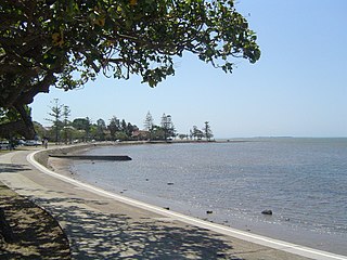
Wynnum Wading Pool is a heritage-listed tidal pool on the foreshore of Moreton Bay at The Esplanade, Wynnum, City of Brisbane, Queensland, Australia. The shallow oval-shaped pool was built in 1932 by relief workers during the Great Depression and opened to the public in 1933. It is also known as Manly Wading Pool and Wynnum Wading Pool Reserve. It was added to the Queensland Heritage Register on 5 October 1998.

Ithaca Embankments

Ithaca Embankments is a heritage-listed group of embankments in the former Town of Ithaca and now in the suburbs of Kelvin Grove, Red Hill and Paddington in Brisbane, Queensland, Australia. They were designed by Alexander Jolly and built from c. 1917 to c. 1923. They were added to the Queensland Heritage Register on 2 March 1993.

Monier Ventilation Shaft 3

Monier Ventilation Shaft 3 is a heritage-listed ventilation shaft at Florence Street, Teneriffe, City of Brisbane, Queensland, Australia. It was designed by Joseph Monier and built c. 1904. It was added to the Queensland Heritage Register on 4 August 1998.

Morningside Air Raid Shelter

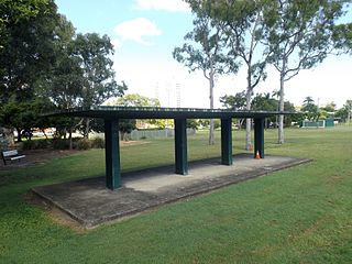
Morningside Air Raid Shelter is a heritage-listed former air raid shelter at 580 Wynnum Road, Morningside, Queensland, Australia. It was designed by Frank Gibson Costello and built c. 1942 by Brisbane City Council. It was added to the Queensland Heritage Register on 6 April 2005.

Raymond Park (West) Air Raid Shelter

Raymond Park (West) Air Raid Shelter is a heritage-listed former air raid shelter in Raymond Park at 94 Baines Street, Kangaroo Point, Queensland, Australia. It was designed by Frank Gibson Costello and built c. 1942 by Brisbane City Council. It was added to the Queensland Heritage Register on 6 April 2005.

Raymond Park (East) Air Raid Shelter Former air raid shelter in Australia

Raymond Park (East) Air Raid Shelter is a heritage-listed former air raid shelter in Raymond Park at 184 Wellington Road, Kangaroo Point, Queensland, Australia. It was designed by Frank Gibson Costello and built c. 1942 by Brisbane City Council. It was added to the Queensland Heritage Register on 6 April 2005.

Dornoch Terrace Bridge

Dornoch Terrace Bridge is a heritage-listed road bridge at Dornoch Terrace, West End, Queensland, Australia. It was added to the Queensland Heritage Register on 1 October 2007.

Wynnum Ambulance Station

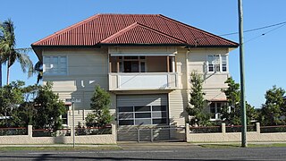
Wynnum Ambulance Station is a heritage-listed museum and former ambulance station at 33 Tingal Road, Wynnum, City of Brisbane, Queensland, Australia. It was built from 1926 to 1927. It is also known as the Queensland Ambulance Museum and the QATB Station. It was added to the Queensland Heritage Register on 26 March 1999. It is open by appointment.

Waterloo Bay Hotel

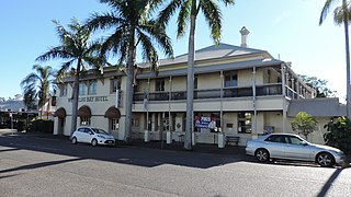
Waterloo Bay Hotel is a heritage-listed hotel at 75 Berrima Street, Wynnum, City of Brisbane, Queensland, Australia. It was built in 1889 by George Gibbs and extended in 1918 to a design by George Henry Male Addison. It was added to the Queensland Heritage Register on 28 July 2000.

Wynnum Fire Station

Wynnum Fire Station is a heritage-listed former fire station at 39 Mountjoy Terrace, Wynnum, City of Brisbane, Queensland, Australia. It was designed by Atkinson & Conrad and built from 1922 to 1938. It was added to the Queensland Heritage Register on 28 May 1999.

Michael Gannon residence

The Michael Gannon residence is a heritage-listed holiday home at 150 Kingsley Terrace, Manly, City of Brisbane, Queensland, Australia. It was built c. 1888. It was added to the Queensland Heritage Register on 27 October 2000.

Christ Church, Tingalpa

Christ Church Tingalpa and Burial Ground is a heritage-listed former Anglican church at 1341 Wynnum Road, Tingalpa, City of Brisbane, Queensland, Australia. It was built from 1868 to 1993. It is now known as the Pioneer Wedding Chapel. It was added to the Queensland Heritage Register on 2 February 1998.

Monier Ventilation Shaft 1

Monier Ventilation Shaft 1 is a heritage-listed ventilation shaft at 500 Wickham Terrace, Spring Hill, City of Brisbane, Queensland, Australia. It was designed by Joseph Monier and built c. 1904. It was added to the Queensland Heritage Register on 4 August 1998.

Monier Ventilation Shaft 2

Monier Ventilation Shaft 2 is a heritage-listed ventilation shaft at 134 St Paul's Terrace, Spring Hill, City of Brisbane, Queensland, Australia. It was designed by Joseph Monier and built c. 1904. It was added to the Queensland Heritage Register on 4 August 1998.

Coronation Drive retaining wall Historic embankment in Brisbane, Queensland

Coronation Drive Retaining Wall is a heritage-listed embankment at Coronation Drive, Brisbane City, City of Brisbane, Queensland, Australia. It was formerly known as the North Quay retaining wall. It was designed by Thomas Kirk and built from 1887 to 1887 by George E Willcocks. It was added to the Queensland Heritage Register on 21 October 1992.

Petrie Bight Retaining Wall Historic embankment in Brisbane, Queensland

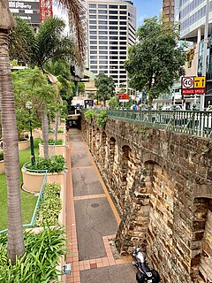
Petrie Bight Retaining Wall is a heritage-listed embankment at 443-501 Queen Street, Brisbane City, City of Brisbane, Queensland, Australia. It was built from 1881 to 1882 by Henry Patten. It was added to the Queensland Heritage Register on 21 October 1992.

Ithaca Creek State School

Ithaca Creek State School is a heritage-listed state school and war memorial at 49 Lugg Street, Bardon, City of Brisbane, Queensland, Australia. It was designed by Queensland Department of Public Work and built from 1930 to 1939. It was added to the Queensland Heritage Register on 5 February 2016.

Wynnum State High School Block A

Wynnum State High School Block A is a heritage-listed building at Wynnum State High School, Peel Street, Wynnum, City of Brisbane, Queensland, Australia. It was built in 1943. It was added to the Queensland Heritage Register on 28 June 2018.

References

  1. 1 2 3 4 5 6 7 8 9 10 11 12 13 14 15 16 17 "Manly Retaining Wall (entry 602039)". Queensland Heritage Register . Queensland Heritage Council. Retrieved 1 August 2014.

Attribution

CC-BY-icon-80x15.png This Wikipedia article was originally based on "The Queensland heritage register" published by the State of Queensland under CC-BY 3.0 AU licence (accessed on 7 July 2014, archived on 8 October 2014). The geo-coordinates were originally computed from the "Queensland heritage register boundaries" published by the State of Queensland under CC-BY 3.0 AU licence (accessed on 5 September 2014, archived on 15 October 2014).

Commons-logo.svg Media related to Manly Retaining Wall at Wikimedia Commons