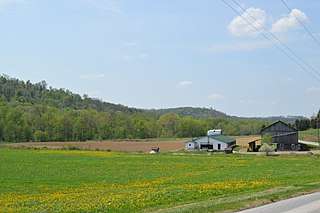
West Mahoning Township is a township that is located in Indiana County, Pennsylvania, United States. The population was 1,337 at the time of the 2020 census.

East Khasi Hills is an administrative district in the state of Meghalaya in India. The district headquarters are located at Shillong. The district occupies an area of 2,748 km² and has a population of 825,922. As of 2011, it is the most populous district of Meghalaya's 12 districts.

Jalaun district is a district of Uttar Pradesh, India. The district is named after the town of Jalaun, which was the former headquarters of a Maratha governor, but the administrative headquarters of the district is at Orai.

Nellore district, officially known as Sri Potti Sriramulu Nellore district in Coastal Andhra Region, is one of the 26 districts in the Indian state of Andhra Pradesh. According to the 2011 Census, the district's population was 2,469,712 of which 29.07% was urban. Its administrative headquarters are located in Nellore city. Located in the Coastal Andhra region, the district is bordered by the Bay of Bengal to the east, Kadapa district and Annamayya district to the west, Prakasam district to the north, and Tirupati district to the south.
Bijawar is a city the state of Madhya Pradesh, India. It is the administrative headquarters of Bijawar Taluk, and was formerly the capital of a princely state of British India of the same name. The people of Bijawar are demanding the district status from their state government. It is the 53rd proposed district of Madhya Pradesh

Seftigen District is one of the 26 administrative districts in the Canton of Bern, Switzerland. Its capital, while having administrative power, was the municipality of Seftigen.
Banswada is a Town and Revenue division in Kamareddy district of the Indian state of Telangana.
Kotturu is a village in Srikakulam district of the Indian state of Andhra Pradesh. It is located in Kothuru mandal of Palakonda revenue division.
Balayapalle is a village and a Mandal in Tirupati district in the state of Andhra Pradesh in India.

Penumuru is a village in Chittoor district of the Indian state of Andhra Pradesh. It is the mandal headquarters of Penumuru mandal.
Parigi is a town and municipality in the Vikarabad district of the Indian state of Telangana. It is located in Parigi mandal of Parigi division
Pennsylvania's 22nd congressional district was one of Pennsylvania's districts of the United States House of Representatives.
Mijakovce is a village in Vranje municipality, Pčinja District, Serbia. In 2002 the village had a population of 37. In 1991, the population was 73.
Madamanuru is a village located in Manubolu Tehsil of Nellore, Andhra Pradesh, India. According to Census 2011 information the location code or village code of Madamanuru village is 592198. It is situated 11km away from sub-district headquarter Manubolu and 37km away from district headquarter Nellore. As per 2009 stats, Madamanur is the gram panchayat of Madamanuru village.

Bijawar State was a princely state of colonial India, located in modern Chhatarpur district of Madhya Pradesh.
Ferwan is a Syrian village located in Sinjar Nahiyah in Maarrat al-Nu'man District, Idlib. According to the Syria Central Bureau of Statistics (CBS), Ferwan had a population of 395 in the 2004 census.
Rapur Assembly constituency was a constituency of the Andhra Pradesh Legislative Assembly, India until 2008.

Almora Legislative Assembly constituency is one of the 70 Legislative Assembly constituencies of Uttarakhand state in India.
Attili was a constituency of the Andhra Pradesh Legislative Assembly, India until 2008.


