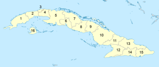
Cuba is an island nation in the Caribbean Sea. It comprises an archipelago of islands centred upon the geographic coordinates 21°3N, 80°00W. Cuba is the principal island, surrounded by four main archipelagos: the Colorados, the Sabana-Camagüey, the Jardines de la Reina and the Canarreos. Cuba's area is 110,860 km2 (42,800 sq mi) including coastal and territorial waters with a land area of 189,731.01 km2 (73,255.55 sq mi), which makes it the eighth-largest island country in the world. The main island (Cuba) has 5,746 km (3,570 mi) of coastline and 28.5 km (17.7 mi) of land borders—all figures including the U.S. Navy's Guantanamo Bay Naval Base.

Administratively, Cuba is divided into 15 provinces and one special municipality. The current structure has been in place since August 2010, when the then-La Habana Province was divided into Artemisa Province and Mayabeque Province.

Catholic University of the North is a university in Chile. It is part of the Chilean Traditional Universities. It is located in Antofagasta, Chile. The Catholic University of the North was founded on May 31, 1956.

The Sierra Maestra is a mountain range that runs westward across the south of the old Oriente Province in southeast Cuba, rising abruptly from the coast. The range falls mainly within the Santiago de Cuba and in Granma Provinces. Some view it as a series of connecting ranges, which join with others to the west. At 1,974 m (6,476 ft), Pico Turquino is the range's – and the country's – highest point. The area is rich in minerals, especially copper, manganese, chromium, and iron.
Modesto Francisco Fernández Díaz-Silveira is a Cuban government official that travels often around the world talking about the environment.
The South American land mammal ages (SALMA) establish a geologic timescale for prehistoric South American fauna beginning 64.5 Ma during the Paleocene and continuing through to the Late Pleistocene. These periods are referred to as ages, stages, or intervals and were established using geographic place names where fossil materials where obtained.
The Jagua Formation is a Late Jurassic geologic formation in the Sierra de los Órganos and Sierra del Rosario mountain ranges in Pinar del Río Province, western Cuba. Plesiosaur, pliosaur, pterosaur, metriorhynchid, turtle and dinosaur remains are among the fossils that have been recovered from its strata.
The Arimao Formation is a geologic formation in Cuba. It preserves mainly ammonite and rudist fossils dating back to the Santonian period.
The Jarao Formation is a geologic formation in Cuba. The dark-colored limestone intercalated with volcanic and tuffaceous formation preserves rudist fossils of Vaccinites inaequicostatus and dates back to the Santonian period.
The Piragua Formation is a geologic formation in Cuba. The limestone intercalated with tuff formation preserves rudist fossils dating back to the Santonian period.
The Canímar Formation is a geologic formation in Cuba. It preserves fossils dating back to the Late Miocene to Pliocene period. Among others, fossils of megalodon have been found in the formation.
The Imías Formation is a geologic formation in Cuba. It preserves fossils dating back to the Miocene period.
The Lagunitas Formation is a geologic formation in Cuba. The open marine, fluvio-deltaic and lagoonal claystones, limestones and conglomerates preserve fossils dating back to the Early Miocene period. Among others, the fossil primate Paralouatta marianae, the largest primate of the Miocene New World, was found in the formation. Based on microfossils, the age has been determined as Burdigalian.
The Consuelo Formation is a geologic formation in Cuba. It preserves fossils dating back to the Priabonian period. The formation is correlated with the Chapapote Formation of Mexico and the Jackson Formation of the United States.
Salta Basin or Salta Rift Basin is a sedimentary basin located in the Argentine Northwest. The basin started to accumulate sediments in the Early Cretaceous (Neocomian) and at present it has sedimentary deposits reaching thicknesses of 5,000 metres (16,000 ft). The basin contains seven sub-basins: Tres Cruces, Lomas de Olmedo, Metán, Alemanía, Salfity, El Rey, Sey and Brealito. The basin environment has variously been described as a "foreland rift" and an "intra-continental rift". The basin developed under conditions of extensional tectonics and rift-associated volcanism.
The following is a timeline of the history of the city of Camagüey, Cuba.
The following is a timeline of the history of the city of Matanzas, Cuba.

The Bogotá Fault is a major inactive slightly dextral oblique thrust fault in the department of Cundinamarca in central Colombia. The fault has a total length of 79.3 kilometres (49.3 mi), while other authors designate a length of 107 kilometres (66 mi), and runs along an average north-northeast to south-southwest strike of 013.5 ± 7 across the Altiplano Cundiboyacense, central part of the Eastern Ranges of the Colombian Andes.

The Chibcha Terrane, named after Chibcha, is the largest of the geological provinces (terranes) of Colombia. The terrane, the oldest explored domains of which date to the Meso- to Neoproterozoic, is situated on the North Andes Plate. The megaregional Romeral Fault System forms the contact of the terrane with the Tahamí Terrane. The contact with the Caribbean and La Guajira Terranes is formed by the regional Bucaramanga-Santa Marta Fault. The northeastern boundary is formed by the regional Oca Fault, bounding the La Guajira Terrane. The terrane is emplaced over the Río Negro-Juruena Province of the Amazonian Craton along the megaregional Eastern Frontal Fault System.


