Manuels River

Last updated
Manuels River
Manuels River Linear Park Municipal Heritage Site Falls.jpg
Manuels River viewed from the Manuels River Trail
Location
CountryCanada
Province Newfoundland and Labrador
Physical characteristics
Source 
  locationAvalon Plateau
Mouth  
  location
Conception Bay
  coordinates
47°31′38″N52°57′06″W / 47.52722°N 52.95167°W / 47.52722; -52.95167 Coordinates: 47°31′38″N52°57′06″W / 47.52722°N 52.95167°W / 47.52722; -52.95167
Length10 km (6.2 mi)
Basin size75 km2 (29 sq mi)

The Manuels River is located in the eastern portion of the town of Conception Bay South, Newfoundland and Labrador. It forms on the high lands of the central Avalon Plateau, traverses approximately 10 kilometres of terrain and empties into the waters of Conception Bay. The river is accessible via walking trails, which start at the Manuels River Hibernia Interpretation Centre located on the Conception Bay Highway.

Contents

Natural features

The river has a natural drainage basin of approximately 75 square kilometres, stretching southward toward the central portion of the Avalon Peninsula. This drainage area contains a high diversity of plant and animal life. A variety of aquatic plants have been identified including sedges, bull rushes and bladderwort. Many species of trees and shrubs common to the boreal forests of eastern Newfoundland thrive on the shoreline and hillsides of the river valley. White birch, cherry, and larch provide spectacular fall colors while fir, black spruce and juniper support the blanket of winter snowfall.

Over thirty different species of wild flowers grow along the edge of the river or under the forest canopy. These include yarrow, thistle, sheep laurel, wild mint, goldenrod and the showy blue flag iris.

Small and large mammals call Manuels River their home. Moose, red fox, and barren ground caribou inhabit the upper reaches of the watershed while hare, squirrels, beaver and muskrat prefer the lower river channel or the mouth.

The variety of bird life spotted along the river or at its mouth include sandpiper, crow, pigeons, juncos, gulls, and the belted kingfisher. The kingfisher enjoys the distinction of being the emblem for the Manuels River Natural Heritage Society.

Diversions

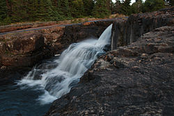
Diversions from the drainage basin, due to the hydroelectric developments, have reduced the volumetric flow considerably. [1]

Fossils

Trilobites are the primary fossil remains found in the rocks of the Manuels River. These prehistoric animals lived on the seabed and left trails as they crawled around in search of food. Trilobites resemble sow bugs (commonly known as 'carpenters') or crabs and were first discovered along the river in 1874 by T.C. Weston of the Geological Survey of Canada. Complete specimens are rare, however, some have been found measuring as long as 30 cm. Many of the fossil remains are fragments of their shells discarded in a manner similar to today's lobsters.

Removing fossil specimens and rock samples is prohibited, but the Society encourages observation and provides educational tours of these wonders from our prehistoric past.

Natural Heritage Society

The river has inspired a volunteer organization, the Manuels River Natural Heritage Society. Its mission is to conserve the river's natural beauty. [2] It maintains a set of walking trails.

Manuels River Hibernia Interpretation Centre

In 2013, a centre was opened to showcase some of the fossils found in the river and the geology of the area. [3]

See also

Related Research Articles

Sunnyside, Newfoundland and Labrador Town in Newfoundland and Labrador, Canada

Sunnyside is a town on the Avalon Peninsula in Newfoundland and Labrador, Canada. It is in Division 1 on Bull Arm.

Clarenville Town in Newfoundland and Labrador, Canada

Clarenville is a town on the east coast of Newfoundland in the province of Newfoundland and Labrador, Canada. Clarenville was incorporated in 1951. It is located in the Shoal Harbour valley, fronting an arm of the Atlantic Ocean called Random Sound.

Conception Bay South Town in Newfoundland and Labrador, Canada

Conception Bay South is a town located on the southern shore of Conception Bay on the Avalon Peninsula of the island of Newfoundland, Province of Newfoundland and Labrador, Canada. The town is commonly called C.B.S. Conception Bay South is the second largest settlement in Newfoundland and Labrador and is part of the St. John's Metropolitan Area.

Carbonear Town in Newfoundland and Labrador, Canada

Carbonear is a town on the Avalon Peninsula in Newfoundland and Labrador, Canada. It overlooks the west side of Conception Bay and had a history long tied to fishing and shipbuilding. Since the late 20th century, its economy has changed to emphasize education, health care, retail, and industry. As of 2018, there were 5,015 people in the community.

Caplin Cove Community in Newfoundland and Labrador, Canada

Caplin Cove is a small community on the north shore of Conception Bay, Newfoundland and Labrador, Canada. It is surrounded on the north by Low Point near the end of the Bay de Verde Peninsula, and on the south by Lower Island Cove. Caplin Cove was probably named for the large body of capelin in its waters.

Hearts Content, Newfoundland and Labrador Town in Newfoundland and Labrador, Canada

Heart's Content is an incorporated town in Trinity Bay on the Bay de Verde Peninsula of Newfoundland and Labrador, Canada.

Harbour Grace Town in Newfoundland and Labrador, Canada

Harbour Grace is a town in Conception Bay on the Avalon Peninsula in the province of Newfoundland and Labrador, Canada. With roots dating back to the 16th century, it is one of the oldest towns in North America.

Northern Bay, Newfoundland and Labrador

Northern Bay is a small community on the northern tip of Conception Bay on the Bay de Verde Peninsula, Subdivision 1G, Newfoundland and Labrador, Canada.

Grand Concourse (St. Johns)

The Grand Concourse is an integrated walkway and green space network connecting 10 municipalities in the Province of Newfoundland and Labrador. It has over 200 kilometers (120 mi) of walkways linking every major park, river, pond, and green space in the Northeast Avalon region. The Grand Concourse is managed by the Grand Concourse Authority, a non-profit organization with a Board of Directors made up of representatives from a variety of community-based and government groups.

East Coast Trail

The East Coast Trail (ECT) is a long-distance coastal footpath located in the Canadian province of Newfoundland and Labrador. It is a developed trail over 336 kilometres (209 mi) long, creation of which began in 1994. It is made up of 25 linked wilderness paths and passes through more than 30 communities. It was named one of the best adventure destinations by National Geographic in 2012 and is extended and improved yearly.

Geography of Newfoundland and Labrador Lands of Canadas eastern-most province

Newfoundland and Labrador is the easternmost province in Canada. The Strait of Belle Isle separates the province into two geographical divisions, Labrador and the island of Newfoundland. The province also includes over seven thousand small islands.

<i>Agraulos</i> Genus of trilobites

Agraulos Hawle & Corda 1847, is a genus of trilobites that lived during the Middle Cambrian in North America and Europe, particularly the Czech Republic.

Bay Roberts Town in Newfoundland and Labrador, Canada

Bay Roberts is located on the north shore of Conception Bay on the northeastern Avalon Peninsula in the province of Newfoundland and Labrador, Canada. The growth of the local economy can be connected to the town's proximity to other major Newfoundland markets, by road and by water.

The Bay du Nord River is located on the south coast of the Island of Newfoundland in the Canadian province of Newfoundland and Labrador. Much of the drainage basin is contained within the Middle Ridge Wildlife Reserve and the Bay du Nord Wilderness Reserve of central Newfoundland.

North River, Newfoundland and Labrador Town in Newfoundland and Labrador, Canada

North River is a town on the Avalon Peninsula of Newfoundland in the Canadian province of Newfoundland and Labrador.

Portugal Cove South is a small fishing town on the southern shore of the Avalon Peninsula of Newfoundland in the province of Newfoundland and Labrador, Canada. It is located 138 km south of St. John's.

Mistaken Point Ecological Reserve

Mistaken Point Ecological Reserve is a wilderness area and a UNESCO World Heritage Site located at the southeastern tip of Newfoundland's Avalon Peninsula in the Canadian province of Newfoundland and Labrador. The reserve is home to the namesake Mistaken Point Formation, which contains one of the most diverse and well-preserved collections of Precambrian fossils in the world. Ediacaran fossils discovered at the site constitute the oldest known remnants of multicellular life on Earth.

Division No. 1, Subdivision G, Newfoundland and Labrador Unorganized territory in Newfoundland and Labrador, Canada

Division No. 1, Subdivision G is an unorganized subdivision on the Avalon Peninsula in Newfoundland and Labrador, Canada. It is in Division 1 and contains the unincorporated communities of Baccalieu Island, Besom Cove, Bradley's Cove, Burnt Point, Caplin Cove, Daniel's Cove, Grates Cove, Gull Island, Job's Cove, Kingston, Long Beach, Lower Island Cove, Low Point, Northern Bay, Ochre Pit Cove, Red Head Cove, Riverhead, Smooth Cove and Western Bay.

Outline of Newfoundland and Labrador Overview of and topical guide to Newfoundland and Labrador

The following outline is provided as an overview of and topical guide to Newfoundland and Labrador.

References

  1. Hydrology. Manuels River Natural Heritage Society. Available at: http://www.manuelsriver.com/pages/hydrology.html Archived 2010-04-04 at the Wayback Machine . Accessed on: 21 July 2013.
  2. About the Society. Manuels River Natural Heritage Society. Available at: http://www.manuelsriver.com/pages/society.html Archived 2002-10-20 at the Wayback Machine . Accessed on: 21 July 2013.
  3. Manuels River Hibernia Interpretation Centre. nlgeotourism.com. Available at: http://www.nlgeotourism.com/content/manuels-river-hibernia-interpretation-centre/nflE8D07498EE3A0C17B. Accessed on: 21 July 2013.