Abel Iturralde is one of the twenty provinces of the Bolivian La Paz Department. It is situated in its northern part. Its name honors Abel Iturralde Palacios, a Bolivian politician. Madidi National Park is partially in this province.

Bautista Saavedra is one of the twenty provinces of the Bolivian La Paz Department situated in the northwestern parts of the department. It was created on November 17, 1948 in honor of Bautista Saavedra Mallea (1870-1939) who was Bolivia's president from 1920 to 1925. The capital of the province is Charazani.

Caranavi Province is one of the twenty provinces of the Bolivian La Paz Department and is situated in the department's eastern parts. The province was created by Law 1401 on 16 December 1992 from a portion of what was then Nor Yungas Province. The creation of the province had been a local cause embraced by Ramiro Revuelta, a Deputy in the national legislature who was assassinated on November 28, 1992.

Omasuyos or Uma Suyu is a province in the La Paz Department in Bolivia. Its capital is Achacachi.

San Borja is a city in the Beni Department in northern Bolivia, It is the most populous city in the province of General José Ballivián.
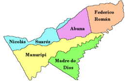
Abuná is one of the five provinces of the Bolivian department of Pando and is situated in the department's northern central parts. It has its name from Río Abuná, the border river to neighbouring Brazil.
Federico Román is one of the five provinces of the Bolivian department of Pando and is situated in the department's northeastern parts. Its name honours General Federico Román.

Madre de Dios is one of the five provinces of the Bolivian Pando department and is situated in the southern parts of the department. Its name derives from Madre de Dios River on the northern border of the province.

Nicolás Suárez is one of the five provinces of the Bolivian Pando department and is situated in the department's northwestern parts. Its name honors Nicolás Suárez Callaú (1861-1940) who owned major parts of today's Pando and Beni Departments in the times of the caoutchouc-boom.

Ñuflo de Chávez is one of the fifteen provinces of the Bolivian Santa Cruz Department and is situated in the northern and central parts of the department. The name of the province honors the conquistador Ñuflo de Chaves (1518–1556) who founded the city of Santa Cruz de la Sierra. Its capital is Concepción. The province was created by law of September 16, 1915, during the presidency of Ismael Montes. Originally it was part of the Chiquitos Province.
Manuel María Caballero Province is one of the fifteen provinces of the Bolivian Santa Cruz Department and is situated in the department's western parts. The province name honors deputy Manuel María Caballero from Vallegrande, one of the signatories of the Bolivian constitution of 5 August 1861.

Ichilo is one of the fifteen provinces of the Bolivian Santa Cruz Department and is situated in the department's north-western parts. The province was founded by a decree of 8 April 1926 and is named after Río Ichilo which is forming the province border in the West.

Ángel Sandoval Province is one of the fifteen provinces of the Bolivian Santa Cruz Department and is situated in the department's eastern parts.

Andrés Ibáñez Province is one of the fifteen provinces of the Bolivian Santa Cruz Department, situated in the western part of the department. Its capital is Santa Cruz de la Sierra which is also the capital of the department.

Chiquitos Province is one of the fifteen provinces of the Bolivian Santa Cruz Department, situated in the center of the department. Its capital is San José de Chiquitos.
Sipe Sipe is a location in the Cochabamba Department in central Bolivia. It is the seat of the Sipe Sipe Municipality, the second municipal section of the Quillacollo Province.
Don Lorenzo is a small town in the Santa Cruz Department in the South American Andean Republic of Bolivia.
Campanero is a small town in the Santa Cruz Department in the South American Andean Republic of Bolivia.
San José is a small town in the Santa Cruz Department in the South American Andean Republic of Bolivia.

Azurduy Municipality is the first municipal section of Azurduy Province in the Chuquisaca Department of Bolivia. Its seat is Villa Azurduy. In 2012 the population was 10,594 persons. The municipality is very poor; in 2010 93% were below the poverty line, and 75% were in extreme poverty. In 2001 there were seven automobiles in the municipality.