Manusmuria

Last updated

Manusmuria

Manusmuria
Village
India Jharkhand location map.svg
Red pog.svg
Manusmuria
Location in Jharkhand, India
India location map.svg
Red pog.svg
Manusmuria
Manusmuria (India)
Coordinates: 22°16′51″N86°44′19″E / 22.28083°N 86.73861°E / 22.28083; 86.73861 Coordinates: 22°16′51″N86°44′19″E / 22.28083°N 86.73861°E / 22.28083; 86.73861
CountryFlag of India.svg  India
State Jharkhand
District East Singhbhum
Population
  Total9,800
Languages
  Official Hindi, Bengali, Oriya
Time zone UTC+5:30 (IST)
PIN
832301
Vehicle registration JH

Manusmuria is a village in Jharkhand, India. It has a population of nearly 9800. [1]

Jharkhand State in Eastern India

Jharkhand is a state in eastern India, carved out of the southern part of Bihar on 15 November 2000. The state shares its border with the states of Bihar to the north, Uttar Pradesh to the northwest, Chhattisgarh to the west, Odisha to the south and West Bengal to the east. It has an area of 79,710 km2 (30,778 sq mi). It is the 15th largest state by area, and the 14th largest by population. Hindi is the official language of the state. The city of Ranchi is its capital and Dumka its sub capital. The state is known for its waterfalls, hills and holy places; Baidyanath Dham, Parasnath and Rajrappa are major religious sites.

India Country in South Asia

India is a country in South Asia. It is the seventh-largest country by area, the second-most populous country, and the most populous democracy in the world. Bounded by the Indian Ocean on the south, the Arabian Sea on the southwest, and the Bay of Bengal on the southeast, it shares land borders with Pakistan to the west; China, Nepal, and Bhutan to the north; and Bangladesh and Myanmar to the east. In the Indian Ocean, India is in the vicinity of Sri Lanka and the Maldives; its Andaman and Nicobar Islands share a maritime border with Thailand and Indonesia.

Near by places are Chakulia, Baharagora, Kumhardubi, Parulia, Khandamouda, and Jagannathpur - parulia.

Chakulia Place in Jharkhand, India

Chakulia is a small town and a notified area in Purbi Singhbhum district in the state of Jharkhand, India.

Baharagora town in Jharkhand, India

Baharagora is a small town in East Singhbhum district and situated on the south-east corner of Jharkhand, India. It is 60 km from Kharagpur, 90 km from Jamshedpur, 50 km from Baripada & 200 km from Kolkata. Baharagora is a very important hub for transport as National Highway 6/Asian Highway 46 passes through here and almost all the Transport Companies have their transit hub here. National Highway 18 connects NH 6 at Baharagora and NH 2 at Barhi, Jharkhand. It is connected to Baripada in Odisha by NH 18.

Parulia Village in Jharkhand, India

Parulia is a village in East Singhbhum district in the Indian state of Jharkhand. It consists of two separate neighborhoods, Chota Parulia and Bara Parulia. It has a population of nearly 2500. The village is located near the villages of Kumardubi and Jagannathpur.

Related Research Articles

East Singhbhum district District of Jharkhand in India

East Singhbhum (is one of the twenty-four districts of Jharkhand state, India. It was created on 16 January 1990. More than 50% of the district is covered by dense forests and mountains, where wild animals once roamed freely.

National Highway 6 & Economic Corridor 1 (EC1), was a National Highway in India that has been separately designated under the new national highway numbering system. It was officially listed as running over 1,949 km (1,211 mi)from Surat to Kolkata. The route was also known as Asian Highway 46 (AH46) & Mumbai - Kolkata Highway, and Great Eastern Highway.

Asian Highway 46 (AH46) is a route of the Asian Highway Network within India, from Kharagpur in West Bengal to Dhule in Maharashtra. The route is part of old National Highway 6.

Sankar Parulia Village in West Bengal, India

Sankar Parulia is a village under Diamond Harbour police station of Diamond Harbour II CD Block in Diamond Harbour subdivision of South 24 Parganas district in the Indian State of West Bengal.

Jharkhand Legislative Assembly Unicameral legislature of the India state of Jharkhand

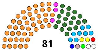
The Jharkhand Vidhan Sabha or the Jharkhand Legislative Assembly is the unicameral state legislature of Jharkhand state in India. The seat of the Vidhan Sabha is at Ranchi, the capital of the state. The Vidhan Sabha comprises 81 Members of Legislative Assembly, directly elected from single-seat constituencies.

Khargram (community development block) Community development block in West Bengal, India

Khargram is a community development block that forms an administrative division in Kandi subdivision of Murshidabad district in the Indian state of West Bengal.

Satapathy(Odia: ଶତପଥୀ)is an Indian surname, found among Utkala Brahmins of Odisha. Alternative spellings include Satpathi, Satpathy and Shatapathy.

Jagannathpur-Parulia Village in Jharkhand, India

Jagannathpur is a village in Jharkhand, India. It has a population of nearly 2500.

Khanda Mouda Village & Panchayat Office in Jharkhand, India

Khandamouda is a village in Jharkhand, India. It has a population of nearly 4000.

Parulia High School is a school situated in Parulia village, Jharkhand, India.

Shyamsundarpur Place in Jharkhand, India

Syamsundarpur is a village in Chakulia community development block in East Singhbhum district of Jharkhand, India. Nearby places are Baharagora and Dhalbhumgar.

National Highway 161 (India) national highway in India

National Highway 161,, is a National Highway in India running through the states of Maharashtra and Telangana of India. The National Highway 161 joins the cities of Akola, Washim, Hingoli, Nanded, Degloor, Pitlam, Narayana Khed, Jogipet, Sanga Reddy.

National Highway 18 (India) national highway in India

National Highway 18 (combination of old NH 32, NH 33 and NH 5) is a National Highway in India. It originates from Gobindpur, Dhanbad and terminates at Balasore, Odisha. It passes through Dhanbad city, Mahuda, Chas, Purulia, Balrampur, Jamshedpur, Ghatshila, Baharagora, Baripada and Balasore. It was earlier NH32 but it got changed in 2012.

Parulia, Bardhaman Village in West Bengal, India

Parulia is a village in Purbasthali II CD block in Kalna subdivision of Purba Bardhaman district in the state of West Bengal, India.

National Highway 161A is a National Highway in India running through the state of Maharashtra. NH 161A joins the cities of Akot, Akola, Barshitakli, Mangrulpir, Digras, Arni, Mahur, Kinwat, Himayatnagar, Mudkhed, Waghala, Mukhed, Maharashtra–Karnataka border in central southern India with each other. It is an auxiliary route of National Highway 61.

Purbasthali College, established in 2009, is an undergraduate general and honours degree college in Parulia in Purbasthali II CD Block in Purba Bardhaman district. It offers undergraduate courses in arts. It is affiliated to University of Burdwan.

Kunal Sarangi Indian politician

Kunal Sarangi is a technocrat turned young politician from the state of Jharkhand. He is a member of the Jharkhand Legislative Assembly from Baharagora, whip and central spokesperson of the principal opposition party Jharkhand Mukti Morcha and member of the Public Accounts Committee ( PAC) of the Jharkhand Legislative Assembly. He represented Jharkhand Legislative Assembly in CPA conference, Goa, Whips' conference in Vizag and Udaipur, and National Legislature Conference in New Delhi. He assumed office on 23 December 2014 and belongs to JMM.

Gopalganj-1 is a constituency represented in the Jatiya Sangsad of Bangladesh since 1996 by Faruk Khan of the Awami League.

References

  1. "Manusmuria Village". baharagora.com. Archived from the original on 24 February 2014. Retrieved 7 April 2012.