Related Research Articles

Transport in the Dominican Republic utilizes a system of roads, airports, ports, harbours, and an urban railway.

A port is a maritime facility comprising one or more wharves or loading areas, where ships load and discharge cargo and passengers. Although usually situated on a sea coast or estuary, ports can also be found far inland, such as Hamburg, Manchester and Duluth; these access the sea via rivers or canals. Because of their roles as ports of entry for immigrants as well as soldiers in wartime, many port cities have experienced dramatic multi-ethnic and multicultural changes throughout their histories.

Manzanillo is a city and seat of Manzanillo Municipality, in the Mexican state of Colima. The city, located on the Pacific Ocean, contains Mexico's busiest port, responsible for handling Pacific cargo for the Mexico City area. It is the largest-producing municipality for the business sector and tourism in the small state of Colima.
Kamarajar Port, formerly Ennore Port, is located on the Coromandel Coast, Chennai about 18 km north of Chennai Port. It is the 12th major port of India, and the first port in India which is a public company. The Kamarajar Port Limited is the only corporatised major port and is registered as a company. Chennai Port Trust acquired around 67% stake of Centre in the Kamarajar Port Limited on 27 March 2020. The remaining 23 percent was already held by the Chennai Port Trust.
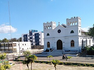
San Fernando de Monte Cristi, also known as Montecristi, is the capital town of Monte Cristi Province in the Dominican Republic. It is located in the northwest region of the country in a coastal area above the border with Haiti.

The Port of Churchill is a privately-owned port on Hudson Bay in Churchill, Manitoba, Canada. Routes from the port connect to the North Atlantic through the Hudson Strait. As of 2008, the port had four deep-sea berths capable of handling Panamax-size vessels for the loading and unloading of grain, bulk commodities, general cargo, and tanker vessels. The port is connected to the Hudson Bay Railway, which shares the same parent company, and cargo connections are made with the Canadian National Railway system at HBR's southern terminus in The Pas. It is the only port of its size and scope in Canada that does not connect directly to the country's road system; all goods shipped overland to and from the port must travel by rail.

The Port of Santo Domingo is located at the mouth of the marine entrance to the city of Santo Domingo, Dominican Republic. The port is suited for both turnaround and transit visits. It is located 16 kilometres from the port of Rio Haina.

The Dominican city of Pedernales is the capital of the Pedernales Province, in the Dominican Republic. It is located in the southwest of the country, on the Dominican Republic–Haiti border, and has a crossing to the Haitian town of Anse-à-Pitres.
The Haina Occidental Port is located in the Haina River, Dominican Republic near Santo Domingo. President Trujillo inaugurated Haina Occidental Port in 1953.
The Multimodal Caucedo Port is located in Caucedo, Boca Chica, Santo Domingo Province, Dominican Republic. This harbor is only used for cargo operations incoming from several countries in the Caribbean zone and is the youngest and the most modern port in the island.

El Port of Puerto Plata is found in San Felipe de Puerto Plata, in Dominican Republic. This is the main port on the north coast and is currently used for cargo operations. In December 2021, the new Taino Bay tourist and cargo terminal was inaugurated.

The Port of Boca Chica is located in Boca Chica, Santo Domingo Este, Dominican Republic. Established in the 1950s to facilitate sugar transportation, the Boca Chica Port has since transformed into a minor hub for cargo operations within the country. The Boca Chica Port is also home to the AES Company's energy-generating facility.
Port of San Pedro de Macoris is located on the Higuamo river, San Pedro de Macoris, Dominican Republic. This port is mainly used to discharge bulk fertilizer, cement, clinker, coal, wheat, diesel and LPG. It is also used to export sugar and molasses produced by several sugar cane mills in the region.
Central Romana Port is located in Romana River, La Romana, Dominican Republic, and belongs to Central Romana Corporation, which also owns the largest sugar mill in the country.
Cayo Levantado Port or Samana Port or Fondeaderon Port is located in Arroyo Barril, Samana, Dominican Republic.
Barahona Port or Port of Barahona is located in Barahona, Dominican Republic.
Port of Azua is located in Azua Province, Dominican Republic.
Pepillo Salcedo is a municipality in the Monte Cristi Province of the Dominican Republic, located next to the border with Haiti. Pepillo Salcedo is frequently named Manzanillo due to the bay of manzanillo Bahia De Manzanillo which is approximately 2 miles from playa el coquito coquito beach. the city received its name from José Antonio Salcedo Ramírez who was a combatant in the long war days of the consolidation of national independence day in the Dominican Republic. General Salcedo Ramírez was also an outstanding military leader in the intense restorative war from 1863 to 1865. Pepillo Salcedo is a coastal town. It is built on the shores of the Bay of Manzanillo. In the westernmost part of the Dominican Northwest.
Manzanillo International Terminal is located east of the Atlantic opening of the Panama Canal on Manzanillo Bay, Colón Province, Panama.

Lightburne was a steam tanker built in 1918–1919 by Texas Steamship Company of Bath for The Texas Company, with intention of transporting oil and petroleum products between Mexican and Gulf ports and the Northeast of the United States. The ship was named after R. W. Lightburne, Jr., a Kansas City-based steamship agent who rendered valuable assistance to the United States Shipping Board during the war.
References
- Manzanillo Port (Spanish)
