Boca Chica is a municipality (municipio) of the Santo Domingo province in the Dominican Republic. Within the municipality there is one municipal district : La Caleta. As of the 2012 census it had 123,510 inhabitants, 70,184 living in the city itself and 53,326 in its rural districts (Secciones).
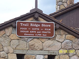
Fall River Pass is a mountain pass in northern Colorado, in the Rocky Mountains of the western United States. It is located in the Front Range, within Rocky Mountain National Park. The pass is traversed by U.S. Highway 34 on Trail Ridge Road between Granby and Estes Park. However, as at Milner Pass on the Continental Divide, the road does not descend after reaching the pass from the west, but instead continues to climb along a side ridge; thus, neither pass is the high point on Trail Ridge Road, which crests at 12,183 feet (3,713 m) elevation, east of Fall River Pass, still within Rocky Mountain National Park. On the other hand, the old, largely unpaved, and one-way-uphill Fall River Road does have its summit at Fall River Pass, where it joins the modern highway for the descent to the west.

The Gulf of Chiriquí is a part of Panama that encompasses Coiba National Park and Golfo de Chiriquí National Park. There are dozens of islands in this Gulf. Along with the islands of Coiba National Park there are also Islas Secas, Isla Los Ladrones, Isla Parida, Isla Boca Brava, Isla Palenque, and Isla Montuosa.
Riosucio is a municipality and town in the Department of Chocó, Colombia. The municipality and town are located in the Atrato River basin, on the Chocoan side of Urabá, a region spanning the departments Chocó and Antioquia.
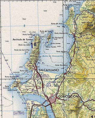
The Bay of Concepción is a natural bay on the coast of the Province of Concepción in the Bío Bío Region of Chile. Within the bay are many of the most important ports of the region and the country, among them Penco, Talcahuano, and Lirquén.

The Port of Santo Domingo is located at the mouth of the marine entrance to the city of Santo Domingo, Dominican Republic. The port is suited for both turnaround and transit visits. It is located 16 kilometres from the port of Rio Haina.
Batey Luisa Airport is located in the municipality of Boca Chica, in the Santo Domingo province of the Dominican Republic. It serves to sports air shows and other air facilities that doesn't have any to be with commercial aviation.
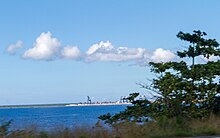
The Multimodal Caucedo Port is located in Caucedo, Boca Chica, Santo Domingo Province, Dominican Republic. This harbor is only used for cargo operations incoming from several countries in the Caribbean zone and is the youngest and the most modern port in the island.
The Port of Puerto Plata is located in San Felipe de Puerto Plata, Puerto Plata, Dominican Republic. This is the main harbor in the north coast and it is currently used for cargo operations and several military movements. Although the government is planning to rebuild the old terminal for commercial passenger operations.
Port of San Pedro de Macoris is located on the Higuamo river, San Pedro de Macoris, Dominican Republic. This port is mainly used to discharge bulk fertilizer, cement, clinker, coal, wheat, diesel and LPG. It is also used to export sugar and molasses produced by several sugar cane mills in the region.
Central Romana Port is located in Romana River, La Romana, Dominican Republic, and belongs to Central Romana Corporation, which also owns the largest sugar mill in the country.
Cayo Levantado Port or Samana Port or Fondeaderon Port is located in Arroyo Barril, Samana, Dominican Republic.
Manzanillo Port is located in Manzanillo, Monte Cristi Province, Dominican Republic. It is very close to the border with Haiti.
Port of Cabo Rojo or Cabo Rojo Port is located in Cabo Rojo, Pedernales, Dominican Republic.
Barahona Port or Port of Barahona is located in Barahona, Dominican Republic.
Port of Azua is located in Azua Province, Dominican Republic.

Starbase is a spaceport, production, and development facility for Starship rockets, located at Boca Chica, Texas, United States. It has been under construction since the late 2010s by SpaceX, an American aerospace manufacturer.

Boca Chica Village, formerly Kennedy Shores, Kopernik Shores, is a small, unincorporated community in Cameron County, Texas, United States. It was formed in the late 1960s, and is still extant as of 2021, although the village proper has changed greatly since 2018 as SpaceX came to purchase much of the land of the village. It lies 20 miles (32 km) east of the City of Brownsville on the Boca Chica peninsula, and forms part of the Brownsville–Harlingen–Raymondville and the Matamoros–Brownsville metropolitan areas. It is situated on Texas State Highway 4, immediately south of the South Bay lagoon, and is located about 2 mi (3.2 km) northwest of the mouth of the Rio Grande.
Boca Chica is an area on the eastern portion of a subdelta peninsula of Cameron County, at the far south of the US State of Texas along the Gulf Coast. It is bordered by the Brownsville Ship Channel to the north, the Rio Grande and Mexico to the south, and the Gulf of Mexico to the east. The area extends about 25 miles (40 km) east of the city of Brownsville. The peninsula is served by Texas State Highway 4—also known as the Boca Chica Highway, or Boca Chica Boulevard within Brownsville city limits—which runs east-west, terminating at the Gulf and Boca Chica Beach.