Santo Domingo Este

Last updated
Santo Domingo Este
Municipality
Municipality of Santo Domingo Este
Faro a Colon SD RD 01 2018 8077.jpg
View of Faro a Colón monument which splits the Distrito Nacional and Santo Domingo Este
Escudo del Municipio Santo Domingo Este.svg
Dominican Republic relief location map.jpg
Red pog.svg
Santo Domingo Este
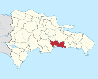
Santo Domingo Este in the Dominican Republic
Coordinates: 18°29′7.79″N69°52′24.26″W / 18.4854972°N 69.8734056°W / 18.4854972; -69.8734056
CountryFlag of the Dominican Republic.svg  Dominican Republic
Province Santo Domingo
Municipality since2001
Government
  MayorManuel Jiménez
Area
[1]
  Total106.29 km2 (41.04 sq mi)
Population
 (2012) [2]
  Total701,269
  Density6,600/km2 (17,000/sq mi)
Municipal Districts
1
Website http://www.asde.gob.do/

Santo Domingo Este is a municipality and the provincial capital of the Santo Domingo province in the Dominican Republic. It has one municipal district (distrito municipal), San Luis. [3]

Contents

Santo Domingo Este is across the Ozama River which divides the east and west sections of metropolitan Santo Domingo. This eastern side is more residential and less commercially developed, but it too has experienced growth, though at a slower pace than Santo Domingo itself, with new malls and department stores.

History

Santo Domingo Este was created as a separate municipality in 2001 by Law 163-01, which split the Santo Domingo province from the Distrito Nacional. [4]

Plans for local government separate from the National District were first floated in the 1970s. Congress considered a bill in 1984 that would have created the province of Santo Domingo Oriental, which was rejected on grounds that the creation of a new province would be unconstitutional.

Culture

Santo Domingo Este has a variety of shopping centers, some of them among the largest in the country, such as Mega Centro and Coral Mall. There are also commercial districts in the Venezuela Avenue and St. Vincent de Paul areas, which feature active nightlife and restaurants.

The municipality also includes the Villa Panamericana, a housing complex built for the athletes of the 2003 Pan American Games.

Economy

Santo Domingo Este Faro a Colon (14643701721).jpg
Santo Domingo Este

Santo Domingo Este has three duty-free zones. Hainamosa is home to 11 businesses and 3,000 employees; San Isidro houses 26 businesses and 7,470 employees; and Los Mina has just one business and 6,000 employees. The New Isabela Industrial Park is also located in the municipality.

Companies with a presence in the area include Barceló, Manufacturera Sociedad Industrial, Lácteos Dominicanos, Parmalat, Telever, Codetel, Tricom, as well as construction, energy, and agricultural businesses.

Sectors

When the city was created, these sectors were also divided:

Tourist attractions

Los Tres Ojos national park. LosTresOjos.JPG
Los Tres Ojos national park.

Related Research Articles

<span class="mw-page-title-main">San Cristóbal Province</span> Province of the Dominican Republic

San Cristóbal is a province in the southern region of Dominican Republic, located west of the capital Santo Domingo. With approximately 642,000 inhabitants, it is the fourth most populated province in the country, only behind Santo Domingo, Santiago and the National District. It borders the provinces Monseñor Nouel (north), Monte Plata (northeast), Santo Domingo (east), Peravia (west) and San José de Ocoa (northwest). The Caribbean Sea borders the province to the south. The provincial capital is the city of San Cristóbal.

<span class="mw-page-title-main">Santo Domingo Province</span> Province of the Dominican Republic

Santo Domingo is a province of the Dominican Republic. It was split from the Distrito Nacional on October 16, 2001.

<span class="mw-page-title-main">Fusagasugá</span> Municipality and city in Andean Region, Colombia

Fusagasugá or Fusa is a city and municipality in the department of Cundinamarca, in central Colombia. It is located in the warm valley between the rivers Cuja and Panches, a central region of the Andes Mountains in South America. The municipality has a population of 138,498 and the urban centre a population of 114,722. The municipality itself covers an area of 194 km2 (75 sq mi).

Santo Domingo Norte is a municipality of the Santo Domingo Province in the Dominican Republic. There is one municipal district within the municipality: La Victoria.

Villa Duarte is a sector in the city of Santo Domingo Este in the province of Santo Domingo of the Dominican Republic. Villa Duarte was originally part of the capital city Santo Domingo, Distrito Nacional. Santo Domingo Este was created as municipality in 2001 by law 163-01, splitting the Santo Domingo province from the Distrito Nacional, with Santo Domingo Este taking the other sectors of Alma Rosa I, Alma Rosa II, El Almirante, Hainamosa, Invivienda, Lucerna, Mendoza, Ozama, Ralma, San Isidro, Sans Sousi, Urbanización Italia, and others.

Los Mina is a sector in the city of Santo Domingo Este in the province of Santo Domingo of the Dominican Republic. Los Mina was part of Santo Domingo, Distrito Nacional. Santo Domingo Este was created as municipality in 2001 by law 163-01, splitting the Santo Domingo province from the Distrito Nacional with Santo Domingo Este taking the other sectors of Alma Rosa I, Alma Rosa II, El Almirante, Hainamosa, Invivienda, Lucerna, Mendoza, Ozama, Ralma, San Isidro, Sans Sousi, and Urbanización Italia.

<span class="mw-page-title-main">Mucarabones</span> Barrio of Toa Alta, Puerto Rico

Mucarabones is a barrio in the municipality of Toa Alta, Puerto Rico. Its population in 2010 was 23,221.

<span class="mw-page-title-main">Ortíz, Toa Alta, Puerto Rico</span> Barrio of Puerto Rico

Ortíz is a large barrio in the municipality of Toa Alta, Puerto Rico. Its population in 2010 was 26,580.

<span class="mw-page-title-main">Hato Abajo, Arecibo, Puerto Rico</span> Barrio of Puerto Rico

Hato Abajo is a barrio in the municipality of Arecibo, Puerto Rico. Its population in 2010 was 19,699.
<span class="mw-page-title-main">Bayamón, Cidra, Puerto Rico</span> Barrio of Puerto Rico

Bayamón is a barrio in the municipality of Cidra, Puerto Rico. Its population in 2010 was 5,995.

References

  1. Superficies a nivel de municipios, Oficina Nacional de Estadística Archived 2014-11-17 at the Wayback Machine
  2. Censo 2012 de Población y Vivienda, Oficina Nacional de Estadistica
  3. Oficina Nacional de Estadistica, Departamento de Cartografia, Division de Limites y Linderos. "Listado de Codigos de Provincias, Municipio y Distritos Municipales, Actualizada a Junio 20 del 2006" (in Spanish). Archived from the original on 2007-03-14.{{cite web}}: CS1 maint: multiple names: authors list (link)
  4. EL CONGRESO NACIONAL. "Ley No. 163-01 que crea la provincia de Santo Domingo, y modifica los Artículos 1 y 2 de la Ley No. 5220, sobre División Territorial de la República Dominicana" (in Spanish). Archived from the original on 2007-05-18. Retrieved 2007-03-08.