Pepillo Salcedo, Dominican Republic

Last updated
Pepillo Salcedo
Dominican Republic relief location map.jpg
Red pog.svg
Pepillo Salcedo
Coordinates: 19°42′0″N71°45′0″W / 19.70000°N 71.75000°W / 19.70000; -71.75000
CountryFlag of the Dominican Republic.svg  Dominican Republic
Province Monte Cristi
Municipality since1948
Area
[1]
  Total149.32 km2 (57.65 sq mi)
Population
 (2012) [2]
  Total11,588
  Density78/km2 (200/sq mi)
Municipal Districts
0

Pepillo Salcedo is a municipality in the Monte Cristi Province of the Dominican Republic, located next to the border with Haiti. Pepillo Salcedo is frequently named Manzanillo due to the bay of manzanillo Bahia De Manzanillo which is approximately 2 miles from playa el coquito coquito beach. the city received its name from José Antonio Salcedo Ramírez who was a combatant in the long war days of the consolidation of national independence day in the Dominican Republic. General Salcedo Ramírez was also an outstanding military leader in the intense restorative war from 1863 to 1865. Pepillo Salcedo is a coastal town. It is built on the shores of the Bay of Manzanillo. In the westernmost part of the Dominican Northwest.

Contents

Its official name is Pepillo Salcedo, in accordance with Law 2089, of August 25, 1949, whose literature highlights the historical figure of that character who knew how to defend the concept of Dominicanness by first confronting the Haitians and then the Spanish. This town is also popularly known by the names of Manzanillo and Puerto Libertador.

The Municipality of Pepillo Salcedo on the Dominican side and Meillac, on the Haitian side, are the starting points of the border of some four hundred kilometers that divides the two countries. The other end of the border line is at Pedernales and Anse-a-Pitre.

Climate

Climate data for Pepillo Salcedo, Dominican Republic (1961–1990)
MonthJanFebMarAprMayJunJulAugSepOctNovDecYear
Record high °C (°F)37.0
(98.6)
39.4
(102.9)
40.4
(104.7)
38.4
(101.1)
40.5
(104.9)
39.4
(102.9)
41.2
(106.2)
41.4
(106.5)
40.4
(104.7)
40.3
(104.5)
38.4
(101.1)
37.2
(99.0)
41.4
(106.5)
Average high °C (°F)29.4
(84.9)
29.7
(85.5)
30.6
(87.1)
31.0
(87.8)
31.7
(89.1)
33.0
(91.4)
34.1
(93.4)
34.1
(93.4)
33.2
(91.8)
32.2
(90.0)
30.8
(87.4)
29.4
(84.9)
31.6
(88.9)
Average low °C (°F)19.3
(66.7)
19.5
(67.1)
20.5
(68.9)
21.3
(70.3)
22.3
(72.1)
22.9
(73.2)
23.2
(73.8)
23.1
(73.6)
22.7
(72.9)
22.4
(72.3)
21.1
(70.0)
19.7
(67.5)
21.5
(70.7)
Record low °C (°F)13.1
(55.6)
14.2
(57.6)
14.0
(57.2)
15.0
(59.0)
16.0
(60.8)
19.1
(66.4)
17.0
(62.6)
17.5
(63.5)
18.0
(64.4)
19.0
(66.2)
15.3
(59.5)
14.3
(57.7)
13.1
(55.6)
Average rainfall mm (inches)42.7
(1.68)
36.6
(1.44)
38.8
(1.53)
53.3
(2.10)
90.7
(3.57)
90.9
(3.58)
59.6
(2.35)
60.0
(2.36)
81.6
(3.21)
92.2
(3.63)
76.3
(3.00)
55.2
(2.17)
777.9
(30.63)
Average rainy days (≥ 1.0 mm)3.02.72.74.06.76.34.15.25.86.14.53.854.9
Source: NOAA [3]


Sources

T. (2010, March). PEPILLO SALCEDO: PATRIOTA EXCEPCIONAL. Retrieved June 14, 2020, from https://diariodominicano.com/cultura/2018/03/17/262686/pepillo-salcedo-patriota-excepcional-

Related Research Articles

Dajabón Province Province of the Dominican Republic

Dajabón is a northwesternmost province which currently comprising one of the 32 provinces of the Dominican Republic. It is divided into 5 municipalities and its capital city with the same name. It is bordered by the provinces of Monte Cristi to the north, Santiago Rodríguez to the south, Elías Piña to the south and the Nord-Est department of Haiti to the west.

Duarte Province Province of the Dominican Republic

Duarte is a northeastern province which comprises one of the 32 provinces of the Dominican Republic. It is divided into 7 municipalities and its capital city is San Francisco de Macorís. It is bordered by the provinces of María Trinidad Sánchez and Samaná to the east, Monte Plata and Sánchez Ramírez to the south, La Vega and Hermanas Mirabal to the west and Espaillat to the north. It is named after Juan Pablo Duarte, the founder of the Dominican Republic.

Monte Cristi Province Province of the Dominican Republic

Monte Cristi is a province in the northwest of the Dominican Republic. The capital city is San Fernando de Monte Cristi. The spelling Montecristi is also seen. The Montecristi province is located in the Cibao frontier region, on the north coast of the country and borders the nation of Haiti. The land area of the Montecristi province is 1,924.35 km2. It is divided into six municipalities and four municipal districts.

José Antonio Salcedo

General José Antonio Salcedo y Ramírez, "Pepillo" (1816–1864) was born in Madrid, Spain from creole parents of Spanish heritage who had been born in Santo Domingo, and moved to Spain in the year 1815. The names of his parents were José María Salcedo and Luisa Ramírez y Marichal. Leaving Spain, the family moved to Cuba when Salcedo was a year old before settling in the Cibao valley. He grew up near the border of Haiti where he managed large tracts of land, herds of livestock, and a rich timber business in the towns of Hatillo Palma, Estero Balsa, and Botoncillo in the northwest.

Cotuí Place in Sánchez Ramírez, Dominican Republic

Cotuí is a city in the Dominican Republic and is one of the oldest cities of the New World. It is the capital of Sánchez Ramírez Province in the Cibao. During the 1822–44 Haitian occupation, the city was officially designated as Cotuy.

Castillo, Dominican Republic Place in Duarte, Dominican Republic

Castillo is a municipality of the Duarte Province in the Dominican Republic.

Comendador, Dominican Republic Place in Elías Piña, Dominican Republic

Comendador is the capital of the Elías Piña province of the Dominican Republic. It has a border crossing to the Haitian town Belladère.

Loma de Cabrera Place in Dajabón, Dominican Republic

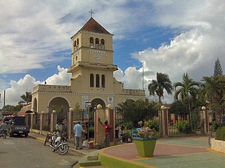
Loma de Cabrera is the second largest city in the province of Dajabón, Dominican Republic. It is located in the northwest portion of the country, in the Cibao region.

Monte Cristi, Dominican Republic Place in Monte Cristi, Dominican Republic

San Fernando de Monte Cristi is the capital town of Monte Cristi Province in the Dominican Republic. It is located in the northwest region of the country in the coastal lowlands near the border with Haiti.

Bayaguana Municipality in Monte Plata, Dominican Republic

Bayaguana is a municipality (municipio) of the Monte Plata province in the Dominican Republic.

Dajabón Place in Dominican Republic

Dajabón is a municipality and capital of the Dajabón province in the Dominican Republic. Located on the northwestern border with Haiti. It is a market town with a population of about 26,000, north of the Cordillera Central mountain range.

Pedro Santana, Dominican Republic Place in Elías Piña, Dominican Republic

Pedro Santana is a city in the province of Elías Piña in the Dominican Republic. It is located on the border of Haiti.

Bánica Place in Elías Piña, Dominican Republic

San Francisco de Bánica, or simply Bánica, is a municipality of the Elías Piña province, on the border with Haiti and near the Artibonite river. The name Bánica comes from the Taíno name of the region, Banique.

Laguna Salada Place in Valverde, Dominican Republic

Laguna Salada is a municipality (municipio) of the Valverde province in the Dominican Republic. Within the municipality there are three municipal districts : Cruce de Guayacanes, Jaibón and La Caya.

Salcedo, Dominican Republic Place in Hermanas Mirabal, Dominican Republic

Salcedo is the capital city of the Hermanas Mirabal Province in the Dominican Republic. It is the birthplace of the Dominican heroines, the Mirabal sisters, who died in the struggle against the dictator Rafael Trujillo. A museum in the town commemorates three of sisters; it was tended to by the remaining sister, Bélgica (Dedé) Mirabal, until her death on February 1, 2014.

Hondo Valle Place in Elías Piña, Dominican Republic

Hondo Valle is a town in the Elías Piña province of the Dominican Republic characterized by its beautiful mountains and cold climate.

El Llano, Dominican Republic Place in Elías Piña, Dominican Republic

El Llano, Dominican Republic is a Dominican municipality in the Elías Piña province.

Juan Santiago, Dominican Republic Place in Elías Piña, Dominican Republic

Juan Santiago is a Dominican municipality in the Elías Piña province.

Pedernales, Dominican Republic capital of Pedernales Province, Dominican Republic

The Dominican city of Pedernales is the capital of the Pedernales Province, in the Dominican Republic. It is located in the southwest of the country, on the Dominican Republic–Haiti border, and has a crossing to the Haitian town of Anse-à-Pitres.

Dominican Republic–Haiti border International border

The Dominican Republic–Haiti border is an international border between the Dominican Republic and the Republic of Haiti on the island of Hispaniola. Extending from the Caribbean Sea in the south to the Atlantic Ocean in the north, the 391 km border was agreed upon in the 1929 Dominican-Haitian border treaty.

References

  1. Superficies a nivel de municipios, Oficina Nacional de Estadistica Archived 2009-04-17 at the Wayback Machine
  2. Censo 2012 de Población y Vivienda,Oficina Nacional de Estadistica Archived 2009-09-19 at the Wayback Machine
  3. "P. Salcedo Climate Normals 1961-1990". National Oceanic and Atmospheric Administration. Retrieved September 18, 2016.

Coordinates: 19°42′N71°45′W / 19.700°N 71.750°W / 19.700; -71.750