
The Dominican Republic is divided into thirty-one provincias, while the national capital, Santo Domingo, is contained within its own Distrito Nacional.

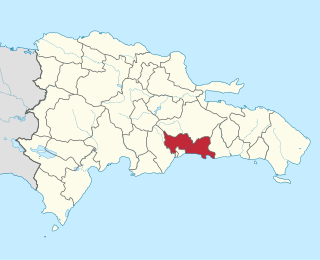
Baoruco, alternatively spelt Bahoruco, is a province of the Dominican Republic located in the southwest of the country, part of the Enriquillo Region, along with the provinces of Barahona, Independencia and Pedernales. Before 1952 it included what is now Independencia Province.

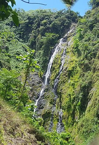
Barahona is a province of the Dominican Republic. Located in the country's southwestern region, it is dividing into 11 municipalities and its capital bears the city of the same name. Barahona borders the provinces of Pedernales to the southwest, Baoruco and Independencia to the north, and Azua to the east along with coastline to the south with the Caribbean Sea. The province has an approximately three hours drive from Santo Domingo the capital of the Dominican Republic. In 2019, volunteers from Amigos de las Americas visited to facilitate projects within the various municipalities of Barahona.

Dajabón is a northwestern province which currently comprises one of the 32 provinces of the Dominican Republic. It is divided into 5 municipalities and its capital city with the same name. It is bordered by the provinces of Monte Cristi to the north, Santiago Rodríguez to the south, Elías Piña to the south and the Nord-Est department of Haiti to the west.

Espaillat is one of the 32 provinces of the Dominican Republic. It is divided into 5 municipalities and its capital city is Moca. Located in north-central Dominican Republic (Cibao), it is bordered by the provinces of La Vega to the south, Santiago and Puerto Plata to the west, and María Trinidad Sánchez to the north-east. The province has a coastline to the north with the Atlantic Ocean. It is named for Ulises Francisco Espaillat (1823–1878), the 19th-century author who was briefly President of the Republic in 1876.
Hato Mayor is a province of the Dominican Republic. The province was split from El Seibo in 1984.
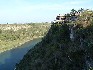
La Romana is a province of the Dominican Republic. The capital is also named La Romana, and is the third-largest city in the country. La Romana was elevated to the category of province in 1944. La Romana is also home to Casa de Campo, one of the world's largest resorts and top golfing destinations, including the Teeth of the Dog golf course. Many international and local artists perform at "Altos de Chavón", an artistic community and university.

María Trinidad Sánchez is a province of the Dominican Republic. It was split from Samaná Province in September 1959 as Julia Molina Province; in November 1961, it got its current name. The name commemorates a distinguished female soldier in the wars of independence. María Trinidad Sánchez was the first woman incarcerated and executed by Pedro Santana, a Dominican annexionist president.

Monte Cristi is a province in the northwest of the Dominican Republic. The capital city is San Fernando de Monte Cristi. The spelling Montecristi is also seen. The Montecristi province is located in the Cibao frontier region, on the north coast of the country and borders the nation of Haiti. The land area of the Montecristi province is 1,924.35 km2. It is divided into six municipalities and four municipal districts.

Puerto Plata ; is a province in northern Dominican Republic. It is divided into 9 municipalities, 12 municipal districts and its capital is the resort city of the same name. Neighboring provinces clockwise: Monte Cristi to the southwest, Valverde and Santiago to the south and Espailat to the east, along with the Septentrional mountain range to the north, and has a coastline with the Atlantic Ocean. The area has become an increasingly popular tourist attraction since the late 1990s mainly due to its fine beaches.

San José de Ocoa is a province in the southern region of the Dominican Republic, and also the name of the province's capital city. It was split from Peravia on January 1, 2000. Published statistics and maps generally include this province in the old, larger, Peravia.

San Pedro de Macorís is a province of the Dominican Republic, also the name of its capital city. The city is fairly active due to its proximity to the national capital of Santo Domingo and also its role in the sugar industry. The province is informally known as San Pedro, SPM or Serie 23 for the first two numbers of their Dominican identification or Cedula.
Santo Domingo is a province of the Dominican Republic. It was split from the Distrito Nacional on October 16, 2001.

Santo Domingo Este is a municipality and the provincial capital of the Santo Domingo province in the Dominican Republic. It has one municipal district, San Luis.
Santo Domingo Oeste is a municipality of the Santo Domingo province in the Dominican Republic. It is part of the greater Santo Domingo metropolitan area, which is the de facto co-capital of the Dominican Republic as seat of the Constitutional Court and the Central Electoral Commission.
Los Alcarrizos is a municipality (municipio) of the Santo Domingo province in the Dominican Republic. Within the municipality there are the following municipal districts : Palmarejo-Villa Linda and Pantoja. The municipality of Los Alcarrizos is home to 336,307 inhabitants (2022), making it one of the most populous municipalities in the country. It forms a northern suburb of Santo Domingo.
Pedro Brand is a municipality (municipio) of the Santo Domingo province in the Dominican Republic. Within the municipality there are two municipal districts : La Cuaba and La Guáyiga.
San Antonio de Guerra is a municipality (municipio) of the Santo Domingo province in the Dominican Republic. Within the municipality there is one municipal district : Hato Viejo.


