Peralta, Azua

Last updated
Peralta
Peralta Azua Dominican Republic rural countryside.jpg
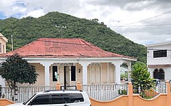
Rural house in Azua, Peralta, Dominican Republic.
Dominican Republic relief location map.jpg
Red pog.svg
Peralta
Coordinates: 18°31′N70°47′W / 18.517°N 70.783°W / 18.517; -70.783
Country Dominican Republic
Province Azua
Area
  Total115.85 km2 (44.73 sq mi)
Population
 (2012)
  Total8,596
  Density74/km2 (190/sq mi)

Peralta is a municipality ( municipio ) of the Azua province in the Dominican Republic. [1]

The village resides at between 5,000 and 7,000 feet in the mountains. It is about a 40 to 50 minutes trip up and down the mountain to the city of Azua de Compostela. The village is primarily focused on agriculture, livestock, and fruits. Electricity is available for all inhabitants in Peralta. However, it does go out from time to time. Blackouts can range from an hour to the whole day.[ citation needed ]

There are two rivers in the village, many of the villagers bathe in the river even though they have access to running water. There are a total of four major barrios : Los Jobos, El Higüero, El Mercado, Camboya.

Related Research Articles

<span class="mw-page-title-main">Xalapa</span> Municipality and City in Veracruz, Mexico

Xalapa or Jalapa, officially Xalapa-Enríquez, is the capital city of the Mexican state of Veracruz and the name of the surrounding municipality. In the 2005 census the city reported a population of 387,879 and the municipality of which it serves as municipal seat reported a population of 413,136. The municipality has an area of 118.45 km2. Xalapa lies near the geographic center of the state and is the second-largest city in the state after the city of Veracruz to the southeast.

<span class="mw-page-title-main">State of Mexico</span> State of central Mexico

The State of Mexico, officially just Mexico, is one of the 32 federal entities of the United Mexican States. Commonly known as Edomex to distinguish it from the name of the whole country, it is the most populous, as well as the most densely populated, state in the country.

<span class="mw-page-title-main">Intibucá Department</span> Department in Honduras

Intibucá is one of the 18 departments in the Republic of Honduras. Intibucá covers a total surface area of 1,186.1 square miles (3,072 km2). Its capital is the city of La Esperanza, in the municipality of La Esperanza.

<span class="mw-page-title-main">Azua Province</span> Province of the Dominican Republic

Azua is a province which is collectively one of the thirty-two provinces of the Dominican Republic. It is divided into 10 municipalities and its capital city is Azua de Compostela. It is bordered by the provinces of La Vega to the north-east, San José de Ocoa and Peravia to the east, Barahona and Baoruco to the west and San Juan to the north-west. To the south, Azua has a significant coastline of the Caribbean Sea. Azua is known for its diverse geography and climate, with the southern part of the province having an arid climate that is not the typical tropical-like that is found in other parts of the Caribbean.

<span class="mw-page-title-main">Peravia Province</span> Province of the Dominican Republic

Peravia is a province in the southern region of the Dominican Republic. Before January 1, 2002 it was included in what is the new San José de Ocoa province, and published statistics and maps generally relate it to the old, larger, Peravia.

<span class="mw-page-title-main">Santiago Province (Dominican Republic)</span> Province of the Dominican Republic

Santiago is a province which currently comprises one of the 32 provinces of the Dominican Republic. It is divided into 10 municipalities and its capital city is Santiago de los Caballeros. Located in north-central Dominican Republic, in the Cibao region, it is bordered by the provinces of Valverde to the north-west, Puerto Plata to the north, Espaillat and La Vega to the east, San Juan to the south and Santiago Rodríguez to the west.

Concepción is a municipality in the Honduran department of Intibucá.

<span class="mw-page-title-main">Azua, Dominican Republic</span> Municipality in Azua, Dominican Republic

Azua de Compostela, also known simply as Azua, is a city, municipality (municipio) and capital of Azua Province in the southern region of Dominican Republic. Founded in 1504, Azua is one of the oldest European settlements in the Americas. The town is located 100 kilometres west of the national capital, Santo Domingo.

<span class="mw-page-title-main">Duvergé</span> Place in Independencia, Dominican Republic

Duvergé, also known locally as Las Damas is the largest city in the province of Independencia in the Dominican Republic. The first settlers of this community were the gentlemen Christopher Pérez and María del Pulgar, originating from San Juan de la Maguana.

<span class="mw-page-title-main">Entrambasaguas</span> Municipality in Cantabria, Spain

Entrambasaguas is a small municipality located in the autonomous community of Cantabria, Spain, 25 km south of the Bay of Santander. It is moderately mountainous, and the origin of the Aguanaz River, which once drove 23 watermills and merges with the Miera River. Limestone caves with Paleolithic rock art and burial sites from the Bronze Age exist. Iron was mined here from prehistoric times, used in the Royal Artillery Factory of La Cavada, which supplied the Armada, and eventually brought some wealth during the Renaissance. First mentioned in 1210, this rural area of Green Spain consists of six towns an area of 43.2 square km, totaling about 5,000 inhabitants as of 2015, having nearly doubled since 2005.

<span class="mw-page-title-main">Oliete</span> Municipality in Aragon, Spain

Oliete is a municipality located in the province of Teruel, Aragon, Spain. According to the 2017 census (INE), the municipality has a population of 357 inhabitants.

<span class="mw-page-title-main">Bohechío</span> Place in San Juan, Dominican Republic

Bohechío is a town in the San Juan province of the Dominican Republic. It is located northeast of the km 25 of Azua – San Juan road at a distance of 26.5 km and 43 km from San Juan Province, 205 km from Santo Domingo and 92 km of the Province Azua, nestled between mountains at the foot of the Cordillera Central. It has a land area of 428.33 km2.

<span class="mw-page-title-main">Guayabal, Azua</span> Municipality in Azua, Dominican Republic

Guayabal is a municipality (municipio) of the Azua province in the Dominican Republic.

Padre Las Casas is a municipality (municipio) of the Azua province in the Dominican Republic. It includes the municipal districts of La Siembra, Las Lagunas, and Los Fríos.

<span class="mw-page-title-main">San Juan Province (Dominican Republic)</span> Province of the Dominican Republic

San Juan is a province of the Dominican Republic. Before 1961 it was known as Benefactor. San Juan is the Republic's largest province, bearing a size of 3,569 square kilometers, and it is landlocked.

<span class="mw-page-title-main">Tulum Municipality</span> Municipality in Quintana Roo, Mexico

Tulum Municipality is one of the eleven municipalities that make up the Mexican state of Quintana Roo. It became a municipality when it was formed on 13 March 2008, at which time it was separated from Solidaridad Municipality.

<span class="mw-page-title-main">El Naranjo, San Luis Potosí</span> Municipality and town in San Luis Potosí, Mexico

El Naranjo is a town and a municipality in the Mexican state of San Luis Potosí in central Mexico. The municipality, created in 1994, has an area of 834 square kilometres (322 sq mi) with a population of 20,495 in 2010, including the town of El Naranjo with a population of 10,562. The town is located at 22°31′19″N99°19′31″W.

Sabana Yegua is a municipality (municipio) of the Azua province in the Dominican Republic.

San Jorge is a municipality in the Guatemalan department of Zacapa, located approximately 8 kilometres (5.0 mi) southwest of the departmental capital, also called Zacapa.

References

  1. Oficina Nacional de Estadistica, Departamento de Cartografia, Division de Limites y Linderos. "Listado de Codigos de Provincias, Municipio y Distritos Municipales, Actualizada a Junio 20 del 2006" (in Spanish). Archived from the original on 14 March 2007. Retrieved 12 August 2011.{{cite web}}: CS1 maint: multiple names: authors list (link)


They do have access to running water (since mid70's.)