
San Cristóbal is a municipality (municipio) and the capital of the San Cristóbal province in the Dominican Republic. Within the municipality there is one municipal district : Hato Damas.

Baoruco, alternatively spelt Bahoruco, is a province of the Dominican Republic located in the southwest of the country, part of the Enriquillo Region, along with the provinces of Barahona, Independencia and Pedernales. Before 1952 it included what is now Independencia Province.

Duarte is a northeastern province which comprises one of the 32 provinces of the Dominican Republic. It is divided into 7 municipalities and its capital city is San Francisco de Macorís. It is bordered by the provinces of María Trinidad Sánchez and Samaná to the east, Monte Plata and Sánchez Ramírez to the south, La Vega and Hermanas Mirabal to the west and Espaillat to the north. It is named after Juan Pablo Duarte, the founder of the Dominican Republic.

Independencia is a province of the Dominican Republic, located in the west, on the border with Haiti. Its capital is Jimani. The province was created in 1948 but was made official in 1950. Before its creation, it was part of the Baoruco Province. The name was given in remembrance of the National Independence of February 27, 1844.

María Trinidad Sánchez is a province of the Dominican Republic. It was split from Samaná Province in September 1959 as Julia Molina Province; in November 1961, it got its current name. The name commemorates a distinguished female soldier in the wars of independence. María Trinidad Sánchez was the first woman incarcerated and executed by Pedro Santana, a Dominican annexionist president.

Monte Cristi is a province in the northwest of the Dominican Republic. The capital city is San Fernando de Monte Cristi. The spelling Montecristi is also seen. The Montecristi province is located in the Cibao frontier region, on the north coast of the country and borders the nation of Haiti. The land area of the Montecristi province is 1,924.35 km2. It is divided into six municipalities and four municipal districts.

Pedernales is the southernmost province of the Dominican Republic, including the offshore island of Isla Beata. It was split from Barahona in 1957. Of its 2,074.53 km2, 1374 km2 belong to the Jaragua National Park. A third of its population is of Haitian origin, the highest ratio within the country.
Peravia is a province in the southern region of the Dominican Republic. Before January 1, 2002 it was included in what is the new San José de Ocoa province, and published statistics and maps generally relate it to the old, larger, Peravia.
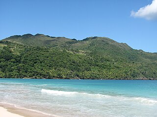
Samaná is a province of the Dominican Republic in the Samaná Peninsula located in the eastern region. Its capital is Santa Bárbara de Samaná, usually known as Samaná.

Higüey, or in full Salvaleón de Higüey, is the capital city of the eastern La Altagracia Province, in the Dominican Republic, and the eighth largest city of that country. The Yuma River flows through the urban areas of Higüey.

Jimaní is the capital and the second largest city of the Independencia Province of the Dominican Republic. It serves as one of the two main border crossings to Haiti, with a duty-free open-air marketplace operating on the border with Haiti. The town suffered damages in the flash flood of May 25, 2004, which killed many citizens during the night and washed away hundreds of homes.

Cabrera is a town in María Trinidad Sánchez province, Dominican Republic. It is located at the eastern end of the country's north coast, at the western extreme of the Scottish Bay, 130 kilometers north of Santo Domingo.
Neiba is a city in the southwest of the Dominican Republic. It is the capital city of the Baoruco province, and is located 180 kilometres west of the national capital, Santo Domingo, close to the shore of Lake Enriquillo, the largest lake in the West Indies.
San Francisco de Bánica, or simply Bánica, is a town and municipality in the northwest region of Dominican Republic in the Elías Piña province. It is located on the border with Haiti near the Artibonite river. The name Bánica comes from the Taíno name of the region, Banique.

San José de las Matas, also known as Sajoma, is an important municipality (municipio) of the Santiago province in the Dominican Republic. The mayor of Sajoma is Alfredo Reyes. there has been many positive changes in the last four years such as adding a 911 system. Within the municipality there are three municipal districts : El Rubio, La Cuesta and Las Placetas.
Navarrete is a municipality in northwestern Dominican Republic, created in 1961. It lies approximately 25 kilometres (16 mi) from Santiago de los Caballeros, Dominican Republic's second largest city. The administrative centre is in the town of Villa Bisonó.
Villa Riva is a municipality (municipio) of the Duarte Province in the Dominican Republic.

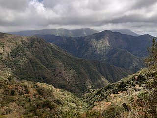
Bohechío is a town in the San Juan province of the Dominican Republic. It is located northeast of the km 25 of Azua – San Juan road at a distance of 26.5 km and 43 km from San Juan Province, 205 km from Santo Domingo and 92 km of the Province Azua, nestled between mountains at the foot of the Cordillera Central. It has a land area of 428.33 km2.
Villa Vásquez is a town in the Monte Cristi province of the Dominican Republic.

The Dominican city of Pedernales is the capital of the Pedernales Province, in the Dominican Republic. It is located in the southwest of the country, on the Dominican Republic–Haiti border, and has a crossing to the Haitian town of Anse-à-Pitres.


