
The City of Westminster is a London borough with city status in Greater London, England. It is the site of the United Kingdom's Houses of Parliament and much of the British government. It contains a large part of central London, including most of the West End, such as the major shopping areas around Oxford Street, Regent Street, Piccadilly and Bond Street, and the entertainment district of Soho. Many London landmarks are within the borough, including Buckingham Palace, Westminster Abbey, Whitehall, Westminster Cathedral, 10 Downing Street, and Trafalgar Square.

The West End of London is a district of Central London, London, England, west of the City of London and north of the River Thames, in which many of the city's major tourist attractions, shops, businesses, government buildings and entertainment venues, including West End theatres, are concentrated.

William Henry Cavendish Cavendish-Bentinck, 3rd Duke of Portland was a British Whig and then a Tory politician during the late Georgian era. He served as chancellor of the University of Oxford (1792–1809) and as Prime Minister of Great Britain (1783) and then of the United Kingdom (1807–1809). The gap of 26 years between his two terms as prime minister is the longest of any British prime minister. He was also an ancestor of King Charles III through his great-granddaughter Cecilia Bowes-Lyon, Countess of Strathmore and Kinghorne.

Great Portland Street is a London Underground station on the Circle, Hammersmith & City and Metropolitan lines between Baker Street and Euston Square stations. Great Portland Street station is listed as a building of National Significance and is in Travelcard Zone 1.

Fitzrovia is a district of central London, England, near the West End. The eastern part of the area is in the London Borough of Camden, and the western in the City of Westminster. It has its roots in the Manor of Tottenham Court, and was urbanised in the 18th century. Its name was coined in the late 1930s by Tom Driberg.

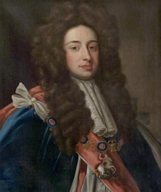
William Henry Cavendish-Scott-Bentinck, 4th Duke of Portland,, styled Marquess of Titchfield until 1809, was a British politician who served in various positions in the governments of George Canning and Lord Goderich.
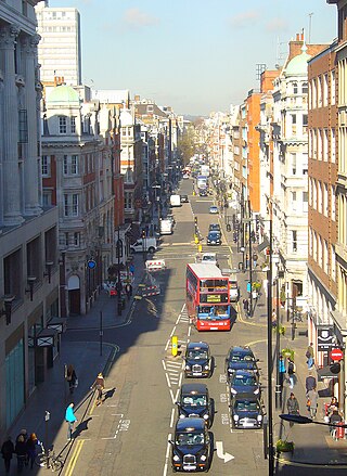
Great Portland Street is a road in the West End of London which links Oxford Street with the A501 Marylebone Road. A commercial street, it divides Fitzrovia, to the east, from Marylebone to the west. It delineates areas with contrasting identities, the west at strongest in grandiose Portland Place and Harley Street, the east at strongest in artists' and independent businesses of Fitzrovia.
John Holles, 1st Duke of Newcastle was an English peer and politician.

Margaret Cavendish Bentinck, Duchess of Portland was the richest woman in Great Britain of her time, styled Lady Margaret Harley before 1734, Duchess of Portland from 1734 to her husband's death in 1761, and Dowager Duchess of Portland from 1761 until her own death in 1785.

Great Titchfield Street is a street in the West End of London. It runs north from Oxford Street to Greenwell Street, just short of the busy A501 Marylebone Road and Euston Road. It lies within the informally designated London area of Fitzrovia. In administrative terms it is in the City of Westminster. It lies within their designated East Marylebone Conservation Area in the former Metropolitan Borough of St Marylebone.

Marylebone is an area in London, England and is located in the City of Westminster. It is in Central London and part of the West End. Oxford Street forms its southern boundary.

Weymouth Street lies in the Marylebone district of the City of Westminster and connects Marylebone High Street with Great Portland Street. The area was developed in the late 18th century by Henrietta Cavendish Holles and her husband Edward Harley, 2nd Earl of Oxford. This part of Marylebone was noted to part of Manor of Tyburn and dates back to the year 1086.

Greenwell Street, formerly Buckingham Street, is located in the East Marylebone district of the City of Westminster in London. It was built in the late eighteenth century and runs between Bolsover Street in the east and Cleveland Street in the west. Great Titchfield Street joins it on its south side. On the south side is the grade II listed George and Dragon public house (c.1850) and the site of the home of the sculptor John Flaxman, the location of which is marked by a plaque.

Audley House is a grade II listed block of flats at 9–12 Margaret Street on the corner with Great Titchfield Street in the City of Westminster, central London, England.

South Audley Street is a major shopping street in Mayfair, London. It runs north to south from the southwest corner of Grosvenor Square to Curzon Street.
This is a list of the etymology of street names in the London district of Fitzrovia. The following utilises the generally accepted boundaries of Fitzrovia viz. Euston Road to the north, Tottenham Court Road to the east, Oxford Street to the south and Great Portland Street to the west.
This is a list of the etymology of street names in the London district of Marylebone. The following utilises the generally accepted boundaries of Marylebone viz. Marylebone Road to the north, Great Portland Street to the east, Marble Arch and Oxford Street to the south and Edgware Road to the west.
The Langham Estate is a property estate in Fitzrovia, London, and is owned by the Mount Eden Land Limited (Guernsey). The company controls 14 acres of real estate in central London. A third of its property portfolio was sold in 2024.

Wimpole Mews is a mews street in Marylebone, London W1, England. It is known for being a key location in the Profumo affair in the early 1960s.


