Blizocin is a village in the administrative district of Gmina Trzebnica, within Trzebnica County, Lower Silesian Voivodeship, in south-western Poland. Prior to 1945 it was in Germany.
Skotniki is a village in the administrative district of Gmina Zawonia, within Trzebnica County, Lower Silesian Voivodeship, in south-western Poland. Prior to 1945 it was in Germany.
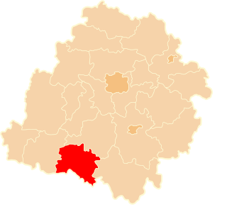
Śliwice is a village in the administrative district of Gmina Długołęka, within Wrocław County, Lower Silesian Voivodeship, in south-western Poland. Prior to 1945 it was in Germany.
Elten is a German village located in North Rhine-Westphalia. It has a population of around 4,500. Since 1975, it has been part of the town Emmerich am Rhein. Between 1949 and 1963, Elten was part of the Netherlands. There is a substantial minority of Dutch citizens.
Grodno is a village in the administrative district of Gmina Nowe Ostrowy, within Kutno County, Łódź Voivodeship, in central Poland. It lies approximately 13 kilometres (8 mi) north-west of Kutno and 60 km (37 mi) north of the regional capital Łódź.

Rożnowice is a village in the administrative district of Gmina Biecz, within Gorlice County, Lesser Poland Voivodeship, in southern Poland. It lies approximately 8 kilometres (5 mi) west of Biecz, 12 km (7 mi) north of Gorlice, and 94 km (58 mi) east of the regional capital Kraków.
Kijany is a village in the administrative district of Gmina Bejsce, within Kazimierza County, Świętokrzyskie Voivodeship, in south-central Poland. It lies approximately 5 kilometres (3 mi) south of Bejsce, 12 km (7 mi) south-east of Kazimierza Wielka, and 75 km (47 mi) south of the regional capital Kielce.
Stare Zakole is a village in the administrative district of Gmina Mińsk Mazowiecki, within Mińsk County, Masovian Voivodeship, in east-central Poland.
Jedlanka Nowa is a village in the administrative district of Gmina Iłża, within Radom County, Masovian Voivodeship, in east-central Poland. It lies approximately 7 kilometres (4 mi) north-east of Iłża, 24 km (15 mi) south-east of Radom, and 114 km (71 mi) south of Warsaw.
Święcice is a village in the administrative district of Gmina Ożarów Mazowiecki, within Warsaw West County, Masovian Voivodeship, in east-central Poland. It lies approximately 8 kilometres (5 mi) west of Ożarów Mazowiecki and 21 km (13 mi) west of Warsaw.
Magdalenów is a village in the administrative district of Gmina Ceków-Kolonia, within Kalisz County, Greater Poland Voivodeship, in west-central Poland.
Nowiny is a village in the administrative district of Gmina Stare Miasto, within Konin County, Greater Poland Voivodeship, in west-central Poland.
Niedarzyn is a settlement in the administrative district of Gmina Skoki, within Wągrowiec County, Greater Poland Voivodeship, in west-central Poland. It lies approximately 5 kilometres (3 mi) south-east of Skoki, 18 km (11 mi) south of Wągrowiec, and 34 km (21 mi) north-east of the regional capital Poznań.

Szonowice is a village in the administrative district of Gmina Rudnik, within Racibórz County, Silesian Voivodeship, in southern Poland. It lies approximately 5 kilometres (3 mi) north-west of Rudnik, 11 km (7 mi) north-west of Racibórz, and 62 km (39 mi) west of the regional capital Katowice.
Rybinka is a settlement in the administrative district of Gmina Stegna, within Nowy Dwór Gdański County, Pomeranian Voivodeship, in northern Poland. It lies approximately 11 kilometres (7 mi) north of Nowy Dwór Gdański and 35 km (22 mi) east of the regional capital Gdańsk.

Krokowa is a village in Puck County, Pomeranian Voivodeship, in northern Poland. It is the seat of the gmina called Gmina Krokowa. It lies approximately 18 kilometres (11 mi) north-west of Puck and 56 km (35 mi) north-west of the regional capital Gdańsk.
Sokoły is a village in the administrative district of Gmina Gołdap, within Gołdap County, Warmian-Masurian Voivodeship, in northern Poland, close to the border with the Kaliningrad Oblast of Russia. It lies approximately 12 kilometres (7 mi) south-west of Gołdap and 121 km (75 mi) north-east of the regional capital Olsztyn.
Wólka Ryńska is a village in the administrative district of Gmina Reszel, within Kętrzyn County, Warmian-Masurian Voivodeship, in northern Poland.
Łekno is a village in the administrative district of Gmina Będzino, within Koszalin County, West Pomeranian Voivodeship, in north-western Poland. It lies approximately 2 kilometres (1 mi) east of Będzino, 12 km (7 mi) west of Koszalin, and 130 km (81 mi) north-east of the regional capital Szczecin.

Violet Grove is a hamlet in central Alberta, Canada within Brazeau County. It is located 7 km (4.3 mi) southwest of Drayton Valley on Highway 620, approximately 110 km (68 mi) southwest of Edmonton.