
Mont Blanc is the highest mountain in the Alps and Western Europe, rising 4,807.81 m (15,774 ft) above sea level. It is the second-most prominent mountain in Europe, after Mount Elbrus, and it is the eleventh most prominent mountain summit in the world. The mountain stands between the regions of Aosta Valley, Italy, and Savoie and Haute-Savoie, France. It gives its name to the Mont Blanc massif, bordering Switzerland and forming part of a larger range referred to as the Graian Alps. The location of the summit of Mont Blanc is on the watershed line between the valleys of Ferret and Veny in Italy and the valleys of Montjoie, and Arve in France, on the border between the two countries. Ownership of the summit area has long been a subject of historical dispute between the two countries.

The Lepontine Alps are a mountain range in the north-western part of the Alps. They are located in Switzerland and Italy.

The Matterhorn is a mountain of the Alps, straddling the main watershed and border between Switzerland and Italy. It is a large, near-symmetric pyramidal peak in the extended Monte Rosa area of the Pennine Alps, whose summit is 4,478 metres (14,692 ft) high, making it one of the highest summits in the Alps and Europe. The four steep faces, rising above the surrounding glaciers, face the four compass points and are split by the Hörnli, Furggen, Leone/Lion, and Zmutt ridges. The mountain overlooks the Swiss town of Zermatt, in the canton of Valais, to the north-east and the Italian town of Breuil-Cervinia in the Aosta Valley to the south. Just east of the Matterhorn is Theodul Pass, the main passage between the two valleys on its north and south sides, which has been a trade route since the Roman Era.
The Mönch at 4,110 metres (13,480 ft) is a mountain in the Bernese Alps, in Switzerland. Together with the Eiger and the Jungfrau, it forms a highly recognisable group of mountains, visible from far away.
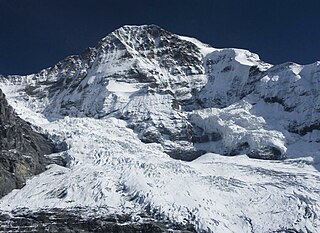
The Breithorn is a mountain range of the Pennine Alps with its highest peak of the same name, located on the border between Switzerland and Italy. It lies on the main chain of the Alps, approximately halfway between the Matterhorn and Monte Rosa and east of the Theodul Pass. Most of the massif is glaciated and includes several subsidiary peaks, all located east of the main summit: the Central Breithorn, the western Breithorn Twin, the Gendarm and the Roccia Nera. The main summit is sometimes distinguished by the name Western Breithorn. The nearest settlements are Zermatt (Valais) and St-Jacques.

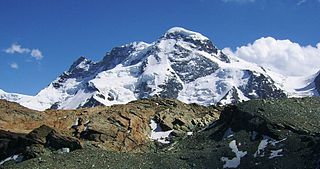
The Dufourspitze is the highest peak of Monte Rosa, an ice-covered mountain massif in the Alps. Dufourspitze is the highest mountain peak of both Switzerland and the Pennine Alps and is also the second-highest mountain of the Alps and Western Europe, after Mont Blanc. It is located between Switzerland and Italy.
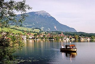
The Rigi is a mountain massif of the Alps, located in Central Switzerland. The whole massif is almost entirely surrounded by the water of three different bodies of water: Lake Lucerne, Lake Zug and Lake Lauerz. The range is in the Schwyzer Alps, and is split between the cantons of Schwyz and Lucerne, although the main summit, named Rigi Kulm, at 1,798 meters above sea level, lies within the canton of Schwyz. The Rigi Kulm Hotel, established in 1816, is located on the summit.

Blanca Peak is the fourth highest summit of the Rocky Mountains of North America and the U.S. state of Colorado. The ultra-prominent 14,351-foot (4,374 m) peak is the highest summit of the Sierra Blanca Massif, the Sangre de Cristo Range, and the Sangre de Cristo Mountains. The fourteener is located 9.6 miles (15.5 km) north by east of the Town of Blanca, on the drainage divide separating Rio Grande National Forest and Alamosa County from the Sangre de Cristo Land Grant and Costilla County. The summit is the highest point of both counties and the entire drainage basin of the Rio Grande. Below the steep North Face of Blanca Peak two live Glaciers once developed, until extinction sometime after 1903. North & South Blanca Glaciers were located at 37° 35N.,longitude 105° 28W. Blanca Peak is higher than any point in the United States east of its longitude.

The Splügen Pass is an Alpine mountain pass of the Lepontine Alps. It connects the Swiss, Grisonian Splügen 5 kilometres (3.1 mi) to the north 675 metres (2,215 ft) below the pass with the Italian Chiavenna 21 kilometres (13 mi) to the south at the end of the Valle San Giacomo 1,789 metres (5,869 ft) below the pass.

The Alps cover a large area. This article describes the delimitation of the Alps as a whole and of subdivisions of the range, follows the course of the main chain of the Alps and discusses the lakes and glaciers found in the region.

Valsolda is a comune (municipality) of about 1,400 inhabitants in the Province of Como in the Italian region Lombardy on the border with Switzerland. It is located about 60 kilometres (37 mi) north of Milan, about 25 kilometres (16 mi) north of Como and 2 kilometres (1.2 mi) east of Lugano.

Monte Generoso is a mountain of the Lugano Prealps, located on the border between Switzerland and Italy and between Lake Lugano and Lake Como. The western and southern flanks of the mountain lie in the Swiss canton of Ticino, whilst the north-eastern flanks are in the Italian region of Lombardy.

The Schesaplana is the highest mountain in the Rätikon mountain range at the border between Vorarlberg, Austria and Graubünden, Switzerland. It has an elevation of 2,964.3 m (9,725 ft).

The Chasseral is a mountain of the Jura Mountains, overlooking Lake Biel in the Swiss canton of Bern. With an elevation of 1,606 metres above sea level, the Chasseral is the highest summit in the canton of Bern outside the Alps. It is also both the northernmost and easternmost mountain reaching over 1,500 metres in the Jura Mountains. West of the summit is located the Chasseral Ouest, where runs the border with the canton of Neuchâtel. The Chasseral Pass is located further on the west.

Piz Badile is a mountain of the Bregaglia range in the Swiss canton of Graubünden and the Italian region of Lombardy. The border between the two countries runs along the summit ridge. Its north-east face, overlooking the Swiss Val Bregaglia near Soglio, is considered one of the six great north faces of the Alps.
The Liro is a torrente, or stream, in the north Italian Province of Como. The drainage basin is triangular in shape; its principal source lies on Monte Marmontana near the Swiss border and flows through the Valle San Iorio. The second source lies to the northeast on the slopes of Pizzo Martello and forms the Valle del Dosso. Near Dosso del Liro the stream receives the waters of the torrente Ronzone, which flows from Monte Duria through the Val d’Inferno. The Liro enters Lake Como at Gravedona.

The Helsenhorn is a mountain of the Lepontine Alps, overlooking Binn in the Swiss canton of Valais. With a height of 3,272 metres above sea level, it is the highest summit of the Binntal. The border with Italy runs approximately 200 metres south-east of the summit and culminates at 3,247 metres.

Val Ferret is the name shared by two valleys separated by the Col Ferret, a pass on the border between Italy and Switzerland. The valleys lie southeast of Mont Blanc Massif. The Swiss valley drains northeast towards Orsières and on into the Rhône basin; whereas the Italian valley drains southwest towards Courmayeur and on into the Po basin.

The Lugano Prealps are a mountain range in the western part of the Alps. They are located in Canton Ticino and in Lombardy.

