
Greifswalder Oie is a small island in the Baltic Sea, located east of Rügen on the German coast. The island covers an area of about 54 hectares. The isle forms part of the municipality of Kröslin.

Thesaban nakhon Trang, City of Trang, or Trang, also called Mueang Thap Thiang (เมืองทับเที่ยง), is a thesaban nakhon and the capital of Trang Province, Thailand. The city has a population of 59,637 (2005) and covers the whole tambon Thap Thiang of Mueang Trang district. Trang is 839 km south of Bangkok.

Mühlacker is a town in the eastern part of the Enz district of Baden-Württemberg, Germany. Mühlacker station has direct rail connections with Stuttgart, Karlsruhe, Heidelberg, Pforzheim and the Northern Black Forest.

Leinefelde-Worbis is a town in the district of Eichsfeld, in northwestern Thuringia, Germany. The town was formed on March 16, 2004, from the former independent towns Leinefelde and Worbis along with the municipalities of Breitenbach and Wintzingerode. In July 2018 the former municipality of Hundeshagen, and in January 2019 Kallmerode was merged into Leinefelde-Worbis. The population before the amalgamation was 14,387 for Leinefelde, 5,541 for Worbis, 1,021 for Breitenbach and 614 for Wintzingerode. The 10 parts of Leinefelde-Worbis are Leinefelde, Worbis, Breitenbach, Kirchohmfeld, Birkungen, Beuren, Hundeshagen, Kaltohmfeld, Wintzingrode, Kallmerode and Breitenholz.

Chaiyaphum is a town in northeastern Thailand, capital of Chaiyaphum Province. As of 2015 it had a population of 58,350, and covers the full tambon Nai Mueang of Mueang Chaiyaphum District. Chaiyaphum is 337 road kilometres northeast of Bangkok.

Kamphaeng Phet is a town in central Thailand, former capital of the Kamphaeng Phet Province. It covers the complete tambon Nai Mueang of the Mueang Kamphaeng Phet district. As of 2020, it has a population of 28,817.
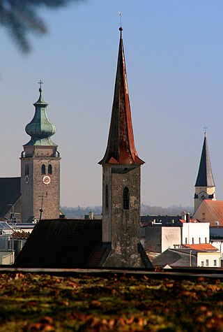
Mühldorf am Inn is a town in Bavaria, Germany, and the capital of the district Mühldorf on the river Inn. It is located at 48°14′30″N12°31′30″E, and had a population of about 17,808 in 2005.

El Bayadh is a municipality of Algeria. It is the capital of El Bayadh Province.
Monte Caseros is a city in the south-east of the province of Corrientes in the Argentine Mesopotamia. It has about 37,000 inhabitants as of the 2010 census [INDEC]. It is the head town of the department of the same name, which comprises also the municipalities of Colonia Libertad, Juan Pujol and Mocoretá.

Leck is a municipality in the district of Nordfriesland, in Schleswig-Holstein, Germany. It is situated approximately 30 km north of Husum, and 30 km west of Flensburg.

Genthin is a town in Jerichower Land district, in Saxony-Anhalt, Germany.

Osterfeld is a town in the Burgenlandkreis district, in Saxony-Anhalt, Germany. It is situated southeast of Naumburg. It is part of the Verbandsgemeinde Wethautal. On 1 January 2010 it absorbed the former municipalities Goldschau, Heidegrund and Waldau.
Besalampy is a rural municipality on the west coast of Madagascar. It belongs to the district of Besalampy, which is a part of Melaky Region. The population of the municipality was 11331 in 2018.

Goldberg is a town in the Ludwigslust-Parchim district, in Mecklenburg-Western Pomerania, Germany. It is situated 24 km northeast of Parchim, and 46 km east of Schwerin.

Dolný Hričov is a village and municipality in Žilina District in the Žilina Region of northern Slovakia.

Lautertal is a municipality in the district of Coburg in Bavaria in Germany. Near Lautertal, there was between 1952 and 1992 a DECCA-transmitter.

Fürstenzell is a municipality in the district of Passau in Bavaria in Germany.
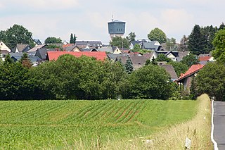
Höhn is an Ortsgemeinde – a community belonging to a Verbandsgemeinde – in the Westerwaldkreis in Rhineland-Palatinate, Germany.
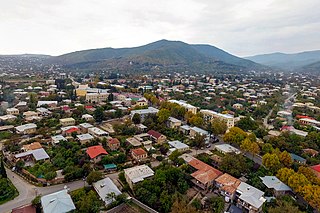
Sagarejo is a town in Kakheti, Georgia. It is situated 58 kilometres (36 mi) east of Georgia's capital, Tbilisi, and has the population of 10,359. It serves as an administrative center of Sagarejo district.

Stachy is a municipality and village in Prachatice District in the South Bohemian Region of the Czech Republic. It has about 1,100 inhabitants. A part of the village is well preserved and is protected by law as a village monument reservation. The local part of Chalupy is also preserved as is protected as a village monument zone.


