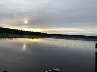
This lake is included in the Châteaufort and Marquette townships. Marquette Lake follows the western boundary (distance between 1.5 kilometres (0.93mi) and 3.5 kilometres (2.2mi)) outside (west side) of the boundary of the Ashuapmushuan Wildlife Reserve.
Forestry is the main economic activity of the sector. Recreational tourism activities come second.
The Forest Road R0212 (East-West) passes the north side of Marquette Lake. It will join to the East, the route 167 connecting Chibougamau and Saint-Félicien, Quebec, as well as the railway of the Canadian National Railway. Other secondary forest roads serve the vicinity of the lake.
The surface of Lac Marquette is usually frozen from early November to mid-May, however, safe ice circulation is generally from mid-November to mid-April.
Geography
This lake has a length of 14.0 kilometres (8.7mi) oriented to the northwest, a maximum width of 1.7 kilometres (1.1mi) and an altitude of 411 metres (1,348ft). This lake expands to 1.2 kilometres (0.75mi) thanks to a bay facing east. This bay is the center of a semicircle of about 5.5 kilometres (3.4mi) of radius on the east side of the lake, with a less rugged terrain whose highest hill reaches an altitude of 492 metres (1,614ft). On the outskirts of this area, a series of mountains has several peaks, the highest reaching 699 metres (2,293ft), or 7.3 kilometres (4.5mi) of the lake. On the west side of the lake, the highest mountain peak is 625 metres (2,051ft), which is 2.6 kilometres (1.6mi) from the west shore of the lake.
From the mouth of Marquette Lake, the current of the Marquette River flows over 64.9 kilometres (40.3mi) generally to the north, to its mouth northwest of the Ashuapmushuan Lake. Then the current flows along the Ashuapmushuan River which flows over 193 kilometres (120mi) to the northeast, then to the south-east to its confluence with the lac Saint-Jean where it empties on the West Bank at Saint-Félicien, Quebec.
Poutrincourt Lake is a freshwater body of the unorganized territory of Lac-Ashuapmushuan, Quebec, in the western part of the Regional County Municipality (MRC) Le Domaine-du-Roy, in the administrative region of Saguenay-Lac-Saint-Jean, in province of Quebec, in Canada. This lake extends in the townships of Poutrincourt and Bouteroue. It is located west of the Ashuapmushuan Wildlife Reserve.
Buade Lake is a freshwater body of the unorganized territory of Lac-Ashuapmushuan, Quebec, in the western part of the Regional County Municipality (MRC) Le Domaine-du-Roy, in the administrative region of Saguenay-Lac-Saint-Jean, in the province of Quebec, in Canada. This lake straddles the townships of Buade and Poutrincourt. It is located west of the Ashuapmushuan Wildlife Reserve.
Nicabau Lake is a freshwater body of the unorganized territory of Lac-Ashuapmushuan, Quebec, in the western part of Regional County Municipality (MRC) Le Domaine-du-Roy, in the Saguenay-Lac-Saint-Jean administrative region, in the province of Quebec, in Canada.
The Normandin River is a tributary of the north shore of Ashuapmushuan Lake, flowing into the unorganized territory of Lac-Ashuapmushuan, Quebec, into the Regional County Municipality (RCM) of Le Domaine-du-Roy, in the administrative region of Saguenay-Lac-Saint-Jean, in Quebec, in Canada.
Normandin Lake is a freshwater body of the unorganized territory of Lac-Ashuapmushuan, Quebec, in the western part of the Regional County Municipality (MRC) Le Domaine-du-Roy, in the administrative region of Saguenay-Lac-Saint-Jean, in the province of Quebec, in Canada.
Little Buade Lake is a freshwater body of the unorganized territory of Lac-Ashuapmushuan, Quebec in the western part of the Regional County Municipality (MRC) Le Domaine-du-Roy, in the Saguenay-Lac-Saint-Jean administrative region, in the province of Quebec, in Canada.
Ashuapmushuan Lake is a freshwater body of the Lac-Ashuapmushuan, Quebec unorganized territory of the Regional County Municipality (MRC) Le Domaine-du-Roy, north-west of Saguenay-Lac-Saint-Jean administrative region, in province of Quebec, Canada.
Bouteroue Lake is a freshwater body of the Lac-Ashuapmushuan, Quebec unorganized territory, in the northwestern part of the Regional County Municipality (MRC) Le Domaine-du-Roy, in the administrative region of Saguenay-Lac-Saint-Jean, in the province of Quebec, in Canada. This lake borders the townships of Rohault, Robert, Ducharme and Bouteroue.
The Bouteroue Creek is a tributary of Lake Nicabau, flowing into the unorganized territory of Lac-Ashuapmushuan, Quebec into the Regional County Municipality (RCM) of Le Domaine-du-Roy, in the Saguenay-Lac-Saint-Jean administrative region, in Quebec, in Canada.
The rivière du Milieu is a tributary of Poutrincourt Lake, flowing into the unorganized territory of Lac-Ashuapmushuan, Quebec, into the Regional County Municipality (RCM) of Le Domaine-du-Roy, in the administrative region of Saguenay-Lac-Saint-Jean, Quebec, Canada.
Frontenac Lake is a freshwater body of the Lac-Ashuapmushuan, Quebec unorganized territory in the northwestern part of the Regional County Municipality (RCM) Le Domaine-du-Roy in the region of Saguenay-Lac-Saint-Jean, in the province of Quebec, in Canada. This lake extends entirely in the canton of Buade.
Marquette River is a tributary of Ashuapmushuan Lake, flowing into the unorganized territory of Lac-Ashuapmushuan, Quebec, into the Regional County Municipality (RCM) of Le Domaine-du-Roy, in the administrative region from Saguenay-Lac-Saint-Jean, in Quebec, in Canada.
The Marquette West River is a tributary of the Marquette River, flowing into the unorganized territory of Lac-Ashuapmushuan, Quebec, in the Regional County Municipality (RCM) of Le Domaine-du-Roy, in the administrative region of Saguenay-Lac-Saint-Jean, in Quebec, in Canada.
Maskoskanaw River is a tributary of Frontenac Lake, flowing into the unorganized territory of Lac-Ashuapmushuan, Quebec, in the Regional County Municipality (MRC) of Le Domaine-du-Roy, in the administrative region of Saguenay-Lac-Saint-Jean, in Quebec, in Canada.
The Palluau Lake is a freshwater body of the Lac-Ashuapmushuan, Quebec unorganized territory in the Regional County Municipality (RCM) Le Domaine-du-Roy, north-west of Saguenay-Lac-Saint-Jean administrative region, in province of Quebec, in Canada.
The rivière au Tonnerre is a tributary of the Normandin River, flowing into the unorganized territory of Lac-Ashuapmushuan, Quebec in the Regional County Municipality (RCM) of Le Domaine-du-Roy, in the administrative region of Saguenay-Lac-Saint-Jean, in Quebec, in Canada.
The Chaudiere River is a tributary of the Normandin River, flowing into the unorganized territory of Lac-Ashuapmushuan, Quebec, into the Regional County Municipality (MRC) of Le Domaine-du-Roy, in the administrative region of Saguenay-Lac-Saint-Jean, Quebec, Canada.
The Aigremont Lake is a freshwater body flowing out of the Little Chief River, flowing into the unorganized territory of Lac-Ashuapmushuan, Quebec, in the northwestern part of the Regional County Municipality (RCM) Le Domaine-du-Roy, in the Saguenay-Lac-Saint-Jean administrative region, in the province of Quebec, in Canada.
The Little River of the Chef is a tributary of the La Loche River, flowing into the unorganized territory of Lac-Ashuapmushuan, Quebec, into the Regional County Municipality (RCM) of Le Domaine-du-Roy, in the administrative region of Saguenay-Lac-Saint-Jean, in Quebec, in Canada.
The Chigoubiche Lake is the main freshwater body at the head of the Chigoubiche River, flowing into the unorganized territory of Lac-Ashuapmushuan, Quebec, in the Regional County Municipality (MRC) Le Domaine-du-Roy, in the administrative region of Saguenay-Lac-Saint-Jean, in the province of Quebec, in Canada.
This page is based on this Wikipedia article Text is available under the CC BY-SA 4.0 license; additional terms may apply. Images, videos and audio are available under their respective licenses.